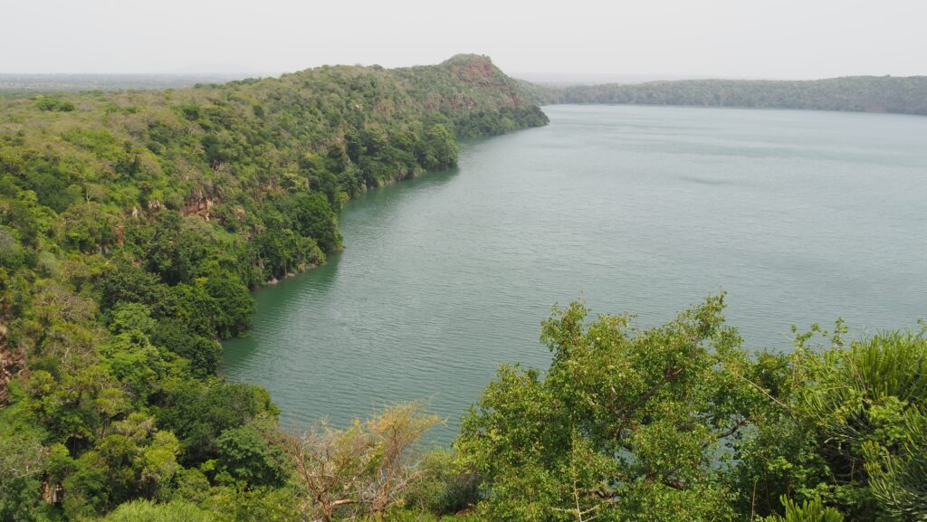
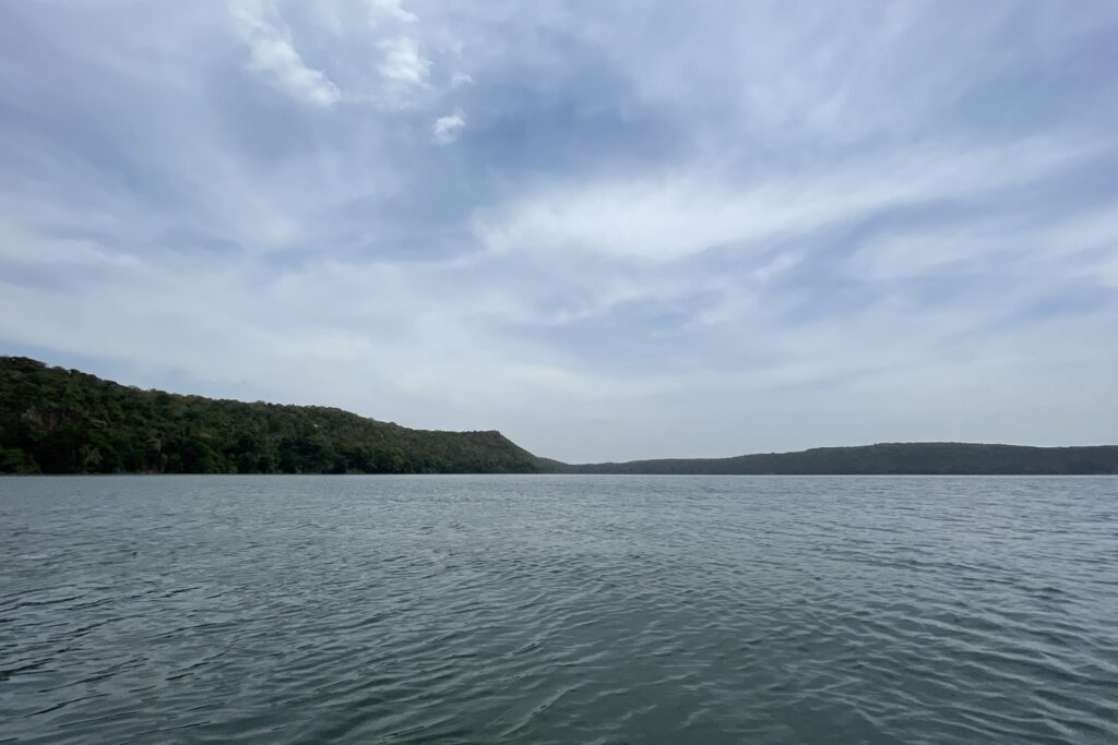
Lake Chala is a stunning crater lake on the border of Tanzania and Kenya. It was formed over 250,000 years ago as a result of volcanic activity associated with Mount Kilimanjaro. It sits in a deep caldera, which was created by a massive eruption that caused the land to cave in, forming the lake basin. Over time, underground springs fed by Kilimanjaro’s glaciers filled the crater, creating the lake we see today.
The depth is estimated to be over 90 meters, making it one of Tanzania’s deepest lakes. It is home to unique fish species, birds, and sometimes even elephants that come to drink from the lake.
Lake Chala is surrounded by mystery and folklore, with local legends passed down through generations. Many locals believe that Lake Chala is bottomless and that its depth is unknown. Some even say that objects or people disappearing into the lake are never seen again.
One legend tells of a battle between the Chaga and Pare tribes, where warriors were pushed into the lake, and their spirits are said to still haunt the waters. Some locals claim to hear whispers or strange sounds coming from the lake at night.
According to another one (created by Chaga people), cattle once mysteriously disappeared from nearby villages, only to reappear on the opposite side of the lake in Kenya. Some believe the lake has an underground tunnel that connects it to other bodies of water, allowing objects (or even animals) to vanish and reappear elsewhere.
Moreover, local stories speak of a water spirit or serpent-like creature that lives in Lake Chala, guarding its depths. Some believe this spirit punishes those who disrespect the lake, leading to unexplained drownings or disappearances. Fishermen and locals often perform small rituals or offerings before entering the lake to seek the spirit’s protection.
How to get there?
Lake Chala is about 55 km from Moshi and 140 km from Arusha.
From Moshi
It’s about a 1.5-hour drive. Take the Moshi–Taveta Road towards the Kenya border. About 7-8 kilometres past Himo, turn right onto a dirt road leading to Lake Chala.
From Arusha
It’s a 3 to 4-hour drive. Drive to Moshi via the Arusha-Moshi Highway and then follow the same route from Moshi to Lake Chala as described above.
By Public Transport
Take a bus or dala-dala from Moshi to Himo Town. From Himo, hire a motorbike (boda-boda) or taxi to the lake.
By Tour Package
Many tour operators in Moshi and Arusha offer guided day trips, including transport, meals, and activities like hiking or kayaking. I found the best price at Karibu Africa House in Moshi – 80 USD, all-inclusive. Ignore other offers asking for 150 – 200 USD as this is a typical Tanzanian rip-off.
Lake Chala
The best time to visit
June to October (Cool and Dry Season): ideal for hiking and wildlife spotting, with less rain and pleasant temperatures.
December to February (Warm and Dry Season): great for swimming and kayaking, with warm temperatures and clear skies.
Months to avoid:
March to May (Long Rainy Season): Heavy rains can make trails muddy and access roads difficult.
November (Short Rainy Season): Occasional showers, but still possible to visit.
Where to stay?
If you want to stay in Moshi and just do a day trip to Lake Chala, I recommend Karibu Africa House and The Better Inn. Both places offer good quality at an affordable price, and they also offer day trips to Lake Chala, but Karibu Africa House is significantly cheaper.
If you decide to spend the night in nature, Lake Chala Safari Lodge and Campsite should be your choice. In February 2025, it was closed for renovation, so call them for more information before going.
Lake Chala
How much does it cost?
If you go solo, you will probably be asked to pay a 30 USD entrance fee. It is a so-called “wildlife fee”, but unfortunately, no wildlife is around. I think it is way too much, and while the lake is pretty, it is not worth that amount of money. Unfortunately, Tanzania is heading in a weird direction as a travel destination for wealthy people, and the prices in many places are simply ridiculous. Result? Nobody is there, so maybe after al,l the strategy doesn’t work…
If you decide to book a trip with an agent, the entrance fee and lunch will be included in the price.
Lake Chala
My experience
After a delicious breakfast at Karibu House Africa, I was picked up but their driver at 9:30 AM and we set off towards Lake Chala, picking up a packed lunch on the way.
We had some usual conversation about Tanzania and Poland, so the time passed quickly, and we approached the turn-off from the tarmac road towards Lake Chala. This section was way more bumpy, but the car wasn’t even 4×4, so it is perfectly doable in dry conditions.
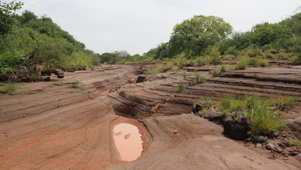
First, the driver went to check in and pay the entrance fee. Then we continued towards Lake Chala Safari Lodge and Campsite, from where we walked to the viewpoint, partly following a dry riverbed and narrow paths in the bush. It was scorching hot, and I felt really lucky I didn’t forget my hat that time.
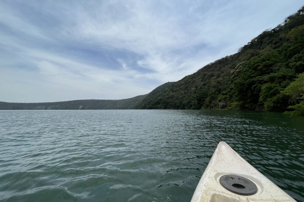
River canyon near Lake ChalaKayaking on Lake ChalaKayaking on Lake Chala
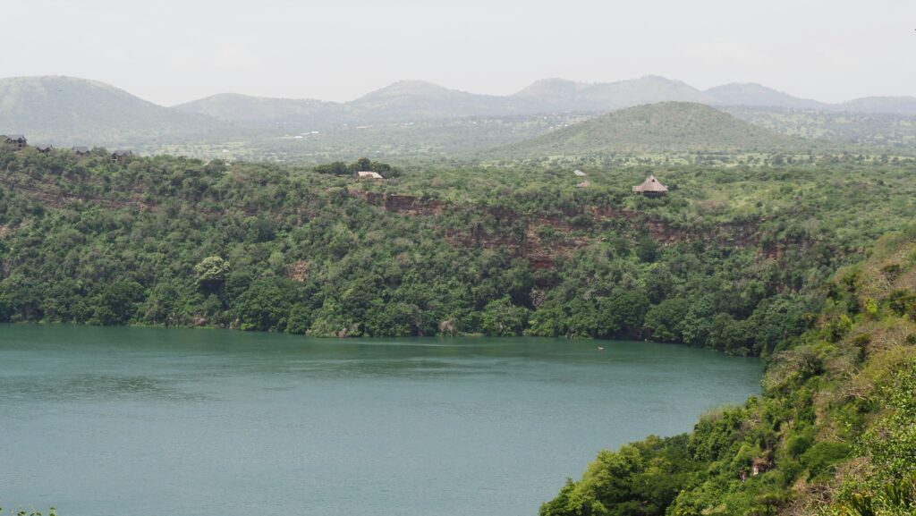
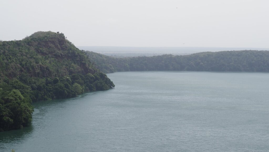
The viewpoint was impressive. We could see a vast panorama of the crater lake, taking the same rest in the shadow of the trees.
Then, we hiked back and went down to the lakeside. I wore a lifejacket and jumped in the kayak as I got the chance to paddle freely around the lake. It was really nice, although the wind was strong, and when I was in the middle, I could feel it pushing me back. Some were monkeys hanging out in the trees, but besides that, I didn’t see any wildlife.
At the end, we had lunch at the shaded observation point near the lodge. We were the only people there, so it was quiet and peaceful.
Was it worth it?
Overall, I spent a nice day at Lake Chala, but taking into consideration how much it costs, it isn’t worth it. I had the feeling that it was just another attraction in Tanzania taking advantage of tourists, trying to rip them off as much as possible. The view of the lake is nice, but it definitely isn’t a “must-see” place.
Mount Longido is a mountain in northern Tanzania, located in the Longido District of the Arusha Region. It rises to about 2,637 meters above sea level and is part of the larger Longido Mountain Forest Reserve. The mountain is known for its lush forests, diverse wildlife, and hiking trails that attract nature enthusiasts and trekkers.
Situated near the Kenya-Tanzania border, Mount Longido provides stunning views of Mount Kilimanjaro, Mount Meru, and the surrounding plains. The area is home to the Maasai people, who graze their cattle on its lower slopes. The trek to the summit is a challenging but rewarding experience, passing through acacia woodlands, montane forests, and rocky outcrops.
It’s not a popular mountain, and very likely you will be the only tourist on the trail. However, if you are planning to climb Kilimanjaro anytime soon, going up to the summit of Mount Longido could be a perfect warm-up!
How to get there?
Getting to Arusha
Most travellers start their journey in Arusha, a major city in northern Tanzania. You can reach Arusha by:
Flight: Fly into Kilimanjaro International Airport (JRO) or Arusha Airport (ARK).
Bus: If coming from other Tanzanian cities like Moshi, there are regular bus services.
Arusha to Longido Town
Mount Longido is about 80 km north of Arusha, along the Arusha–Namanga highway (A104). Travel options include:
Private Car / Taxi: Takes about 1.5 to 2 hours.
Public Bus (Dalla-Dalla) or Shared Car (Noah): Buses run from Arusha to Longido town, but they may be crowded and slow. The best idea is to take a shared car, which is commonly called “Noah”. They leave when full and are packed to the limits, but they are faster. They are heading to the border with Kenya in Namanga, so make sure that the driver knows that he should drop you in Longido.
One place in a shared car (Noah) costs 7.000 TZS.
From Longido Town to the Mountain
The mountain is just a short distance from Longido town. First, you need to go to the office of the Longido Cultural Tourism Programme (LCTP), which offers guided treks and cultural experiences. There, you can organise a permit and a guide. LCTP is located near the Lutheran Church, and there is a sign on the main road going through the town indicating the turn-off to the right if coming from the direction of Arusha. If you can’t find it, just ask guys on motorbikes and they will take you there for a small fee.
The view from the summit
How much does it cost?
After reaching the Longido Cultural Tourism Programme (LCTP) office, you will be asked to pay 60 USD for the guide and permit and 10 USD “village fee” (whatever that means). So, the total cost of the hike for me was 70 USD. I was climbing alone, so I am not sure if the cost is lower in the case of bigger groups but probably yes.
It’s a good idea to contact LCTP before your hike to ensure the guide’s availability. Here is their phone number: +255 787 855 185, and email address: touryman2017@yahoo.com. They are reachable on WhatsApp.
The view of Longido Town
The best time to visit
June to October (Long Dry Season): Cool temperatures and clear skies.
December to February (Short Dry Season): Warmer temperatures, but still good for trekking. Great visibility with clear views of Mount Kilimanjaro and Mount Meru.
Months to avoid:
March to May (Long Rainy Season): Heavy rains can make the trails slippery and difficult.
November (Short Rainy Season): Unpredictable rain showers can make hiking less enjoyable.
How long does it take?
If you are reasonably fit, the hike up and down should take 6-8 hours. You may also opt for an overnight camping adventure, and I am sure it’s a great experience to witness sunrise with views of Kenya, Mount Meru, or even Kilimanjaro.
Hiking trail through the forest
My experience
After I arranged the permit, the guide arrived within a few minutes and looked like he was running the whole way to the tourist office! He wasn’t too talkative, so most of the way, we were walking in silence, and just occasionally, I was asked how I was. Well, it was fine for me as I don’t like unnecessary conversations while going up the mountain or running.
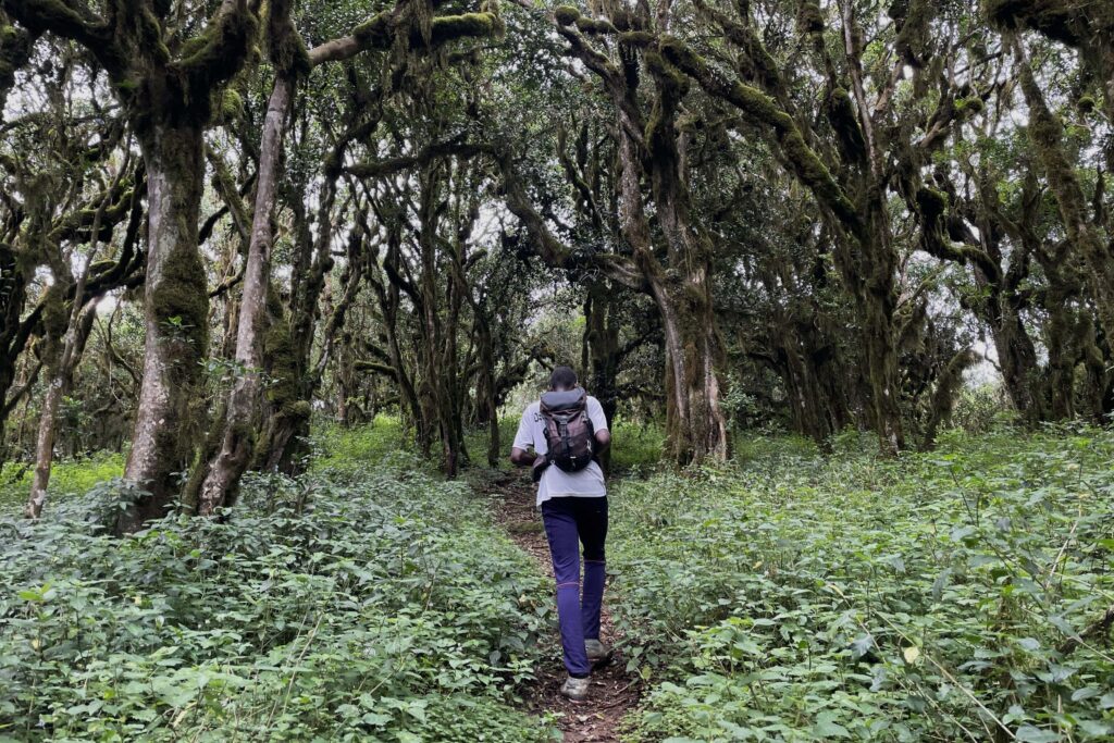
First, we went through the village and then along the stream where children were bathing and washing their clothes. The trail was rocky, with small trees and quite exposed to the sun. Luckily, it was cloudy at that time. Then, we entered the forest, and the trail was getting steeper and steeper. Sometimes we had to speed up as there were plenty of ants all around the path.
The way through a fairy tale forestAlmost there!
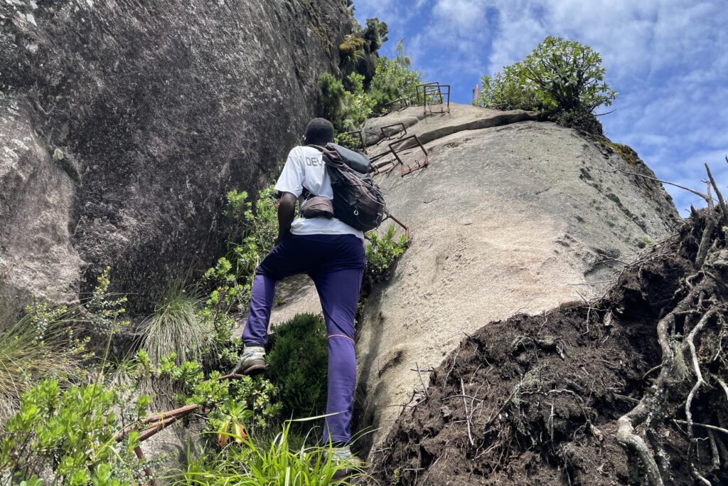
Once we left the forest, it was time for a longer break with a snack. We continued for a short time through the grassland, then entered the forest again. It was a bit similar to the one that I saw in Kilimanjaro with moss-covered trees. From the next plateau, we could already see the summit. I was a little bit anxious when I saw the metal footholds on the almost vertical rock leading to the summit. Luckily, climbing up wasn’t that bad, although the footholds were placed a bit too far from each other to put my feet comfortably.
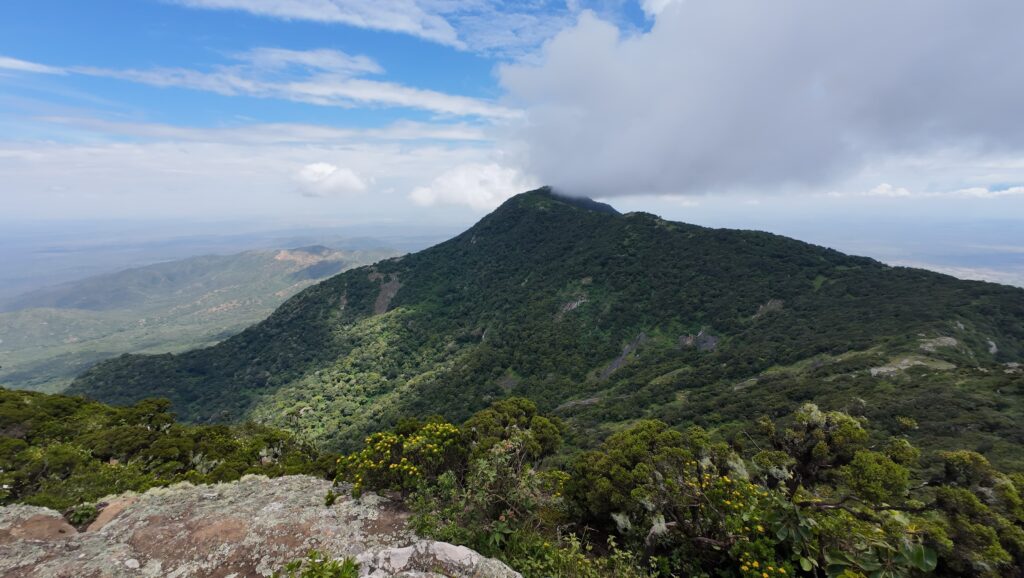
Finally, after ascending more than 1300 meters, we reached the summit from which we could admire an impressive view of Kenya and the plains on the Tanzanian side. Even Maasai bomas were visible! Look for the circular shapes.
Panoramic view from the summit
The weather was much better than I expected. Although we could not see Kilimanjaro as it was a bit too hazy, the sky was mostly blue with some picturesque clouds. I didn’t have to make use of my rain jacket or any warmer layers, but don’t forget to pack yours. The weather in that place can be very changeable!
After snacks and a photo break, we started the descent and (unsurprisingly) going down was way more challenging on those metal footholds! They were way too far from each other, and I was struggling with where to put my feet, but my guide was very helpful, and soon I was at the bottom, wet from sweat. The rest of the way down was perfectly fine and we came back following the same trail as to the top.
Approaching the summitOn the summit of Mount Longido
Overall, a very nice and memorable hike! We didn’t see any wildlife, but the guide told me that there were buffalo around, and there were even some sightings of leopards. It’s a pity we couldn’t see Kilimanjaro, but you need to be quite lucky with that, as it’s best viewed in the morning when it’s less likely to be cloudy. On the other hand, we saw Mount Meru as well as Ol Doinyo Lengai.
When we arrived back at the LCTP office, the guy was trying to organise transport for me back to Arusha, but it seemed that there were no dala-dalas as it was Sunday. He dropped me near the traffic police that was on the roadside, and when an officer stopped an upcoming Land Cruiser, I asked the driver if he was going to Arusha and could give me a lift. He agreed without any issues. I guess the policeman was trying to find a reason to fine him, as the driver got very emotional and they both started shouting at each other. Well, I’m not surprised, the policeman was surely an asshole looking for money to put in his pocket which is common in Tanzania.
The rest of the trip was very smooth, and I arrived at my hotel in Arusha just before sunset.
Metal footholds near the summit
What else to do in Longido Town
The guy from the Longido Cultural Tourism Programme (LCTP) office can help you organise a visit to the Maasai Village, which includes traditional dance. It’s quite pricey (about 150.000 TZS), so it’s better to go in a group to split the costs.
Merzouga is a small village on the edge of the Sahara Desert in southeastern Morocco, known for its towering sand dunes, stunning landscapes, and as a gateway to the vast, golden stretches of the Erg Chebbi. These dunes can reach heights of up to 150 meters and extend over an area of approximately 28 kilometres, creating a surreal, otherworldly landscape that feels remote and ancient.
Merzouga has a unique atmosphere shaped by its desert setting and is celebrated for its vibrant yet tranquil ambience. The village itself is modest and rooted in Berber (Amazigh) culture, with people speaking a mix of Tamazight, Arabic, and French.
The region has become a popular destination for adventurers and cultural travellers who want to experience the Sahara up close. Camel treks at sunrise or sunset are popular, giving visitors the chance to ride through the dunes and witness the landscape’s constantly shifting colours in the warm desert light. Many opt to stay in desert camps under the stars, where traditional Berber meals like tagine are served, often accompanied by live drumming around a campfire.
The ecosystem around Merzouga, despite the arid conditions, is surprisingly rich. During certain times of the year, especially after rain, Merzouga sees migratory birds like flamingos visit its seasonal salt lake, Dayet Srji. The desert’s flora and fauna are specialized to endure extreme conditions, showcasing the adaptability of life in one of Earth’s most challenging climates. Nearby, you’ll find fascinating geological sites and fossil deposits dating back millions of years, along with old kasbahs and ksars (fortified villages) that provide insight into Morocco’s history and the Saharan trade routes that once passed through the area.
How to get there?
Getting to Merzouga can be an adventure in itself, as it’s in a remote part of Morocco near the Algerian border. Here are the main ways to get there, depending on your starting point, time, and budget.
Merzouga
By Car
From Marrakech
The drive is around 9–10 hours (560 km) and passes through the High Atlas Mountains, the Tizi n’Tichka Pass, Ouarzazate, and the Draa Valley. Many people split the trip over two days, often stopping overnight in places like Ait Benhaddou or Dades Valley.
From Fes
The drive takes about 7–8 hours (470 km). You’ll pass through scenic towns like Ifrane, Midelt, and Erfoud, a fossil-rich area that’s also a gateway to the desert.
By Bus
Supratours has a direct, overnight bus from Marrakech and Fes to Merzouga. The journey from Marrakech takes around 12 hours and the one from Fes about 10 hours. The bus arrives in Merzouga early in the morning, allowing you to start desert tours the same day. The buses are typically comfortable and air-conditioned, though the ride is long. It’s recommended to book tickets in advance, especially during peak travel seasons.
By Plane
While Merzouga doesn’t have an airport, the closest ones are in Errachidia and Ouarzazate. Royal Air Maroc operates limited flights from Casablanca to Errachidia. From Errachidia, Merzouga is a two-hour drive by taxi or private transfer. Ouarzazate Airport (OZZ) is another option, but it’s farther away (about 5–6 hours by car).
If you prefer a hassle-free journey, many companies offer multi-day tours that include transport to and from Merzouga, typically starting from Marrakech or Fes. These often include stops at scenic and cultural sites along the way, such as Ait Benhaddou, the Todra Gorge, and the Valley of the Roses. You’ll travel in a comfortable 4×4 or minivan with a guide. Shared group tours are more budget-friendly and include similar stops but may be less flexible.
Where to stay?
I stayed in Auberge Kasbah Des Dunes which was a great choice. The room was very atmospheric, there was a lot of parking space plus a delicious breakfast was included. The owner also helped me to organize an overnight desert experience at Erg Chebbi.
The best time to visit
Spring (March to May): temperatures are warm but comfortable, typically ranging from 20°C to 30°C during the day and cooler in the evenings. This is a beautiful time for desert landscapes, as the sand and skies are vivid, and occasional spring rains may create rare blooms in the desert. Spring is popular with tourists, especially in April, so booking accommodations or desert tours in advance is recommended.
Autumn (September to November): similar to spring, temperatures are mild, with daytime highs around 25°C to 30°C and cooler evenings. October is especially pleasant. Clear skies and beautiful sunsets make autumn a favourite for photographers and those looking to experience the desert at its most vibrant. Autumn also sees a fair number of tourists, but generally fewer than spring. It’s still wise to book ahead, especially in October.
Winter (December to February): days are mild, with temperatures between 15°C to 20°C, but nights can be cold, dropping close to freezing in the desert. The winter sky is often crisp and clear, which is perfect for stargazing. If you’re prepared for the cold nights, winter can be a magical time to experience the desert’s tranquillity. Winter is less crowded, though the holiday period around late December can be busy.
Summer (June to August): daytime temperatures soar, often reaching 40°C to 50°C, making it challenging for outdoor activities. Most tours run early in the morning or late in the afternoon to avoid the midday heat, and many desert camps close or operate with limited services. Fewer tourists visit in summer due to the heat, making it an option for those who want to avoid crowds, but only if you’re comfortable with intense temperatures.
Erg Chebbi
The most famous sand dune region in Morocco spans about 28 kilometres in length and 5–7 kilometres in width, creating a vast sea of reddish-orange sand that stretches to the horizon. Erg Chebbi is often called Morocco’s “gateway” to the Sahara because it offers one of the most accessible ways to experience the true Sahara Desert. While not as vast as the Sahara further east, the experience of walking, riding camels, or camping among these dunes provides an authentic taste of the desert’s allure.
Popular activities include camel trekking, sandboarding, 4×4 off-road excursions, and quad biking. These activities allow visitors to explore the dunes from different perspectives and provide a mix of adventure and relaxation.
Panorama of Erg Chebbi dunes
I went to Erg Chebbi three times: twice independently and once while heading to the desert camp. If you go independently, the dunes can be accessed from many points. Once, I parked near the National 4X4 Auto Museum and set off from there, and at another time I simply walked towards the dunes from my accommodation Auberge Kasbah Des Dunes. Climbing the highest one was huge fun! Not an easy job as my feet sank into the sand but very scenic views from the top! I could hear quads in the distance as the dunes were also a playground for such activities.
Be careful as sometimes strong winds can blow sand straight into your face. It’s good to have some kind of face cover.
Erg Chebbi at sunset
Overnight at the desert camp
Camel trekking is one of the most popular ways to explore Erg Chebbi. Many visitors take a camel ride into the heart of the dunes, often timed for sunrise or sunset to capture the changing colours of the sands. Overnight stays in traditional Berber desert camps are also popular, with accommodations ranging from basic tents to luxurious setups, allowing for an immersive experience under the stars. I arranged my trip through the accommodation upon arrival to Merzouga and I advise you to do the same for the best price.
The start of the trip was planned at 4 PM but it was slightly delayed as we were waiting for 3 more people to join but seemed that they were still on their way. Finally, I set off alone with the guide as they were not even sure if the other guests would come or not. The ride on the camel was a surprisingly long and super nice experience, even though as always the ass hurt and in general I never feel good riding on any type of animal.
We made a short stop to admire the sunset and then continued to the camp. The camp was really small, basically 3 tents for guests, one for the kitchen and one for dining.
Camp in the desert
I was sure I was going to be the only guest which would be quite a boring and miserable experience but then my guide came with dinner and said that the other 3 guests were on their way. It was an American girl and two guys from New Zealand. I didn’t get along with them as I could hardly understand their accent and what the hell they were talking to me 🙂 Plus they were young teenagers and some of their behaviours proved that.
After dinner, we went out a bit deeper into the desert to go sandboarding and look for the desert fox. Unfortunately, none of us had a proper headlamp so we could see shadows of foxes moving around but not very clearly. Sandboarding was cool but in the total darkness, I couldn’t even see where I was going and it was so tiring to climb back to the dune! So a great tip: take a strong headlamp! For me, sitting in the desert looking at the night sky full of stars was an absolute highlight. In moments like that, I could feel that I was halfway between space and Earth. We even saw some shooting stars!
In the morning we woke up for sunrise. It was pretty cold so I was glad that I took some extra layers! After that, we went back to the village riding the camels. I had breakfast in the accommodation and then took a shower. It was very nice that they gave me this opportunity even after checkout time, as my skin was full of sand!
Sunset around the camp
National 4×4 Auto Museum
According to the reviews, the museum features a wide variety of antique 4×4 cars from different eras, all in excellent condition. It’s free but a donation to the guard is welcome. Unfortunately, at the time of my visit, it was closed even though opening hours said it should have been open.
Ouzina
Ouzina is a small village about 60 kilometres south of Merzouga. The local people live in a way that reflects their deep connection to the desert environment, often in adobe houses, and maintain traditional practices, including crafting and agriculture adapted to arid conditions. It is less visited than Merzouga, making it ideal for travellers seeking a more off-the-beaten-path desert experience.
Reaching Ouzina is a bit challenging due to its remote location. Travelers usually take a 4×4 vehicle from Merzouga or Rissani, navigating unpaved desert roads. Many organized tours include Ouzina as part of a multi-day Sahara excursion.
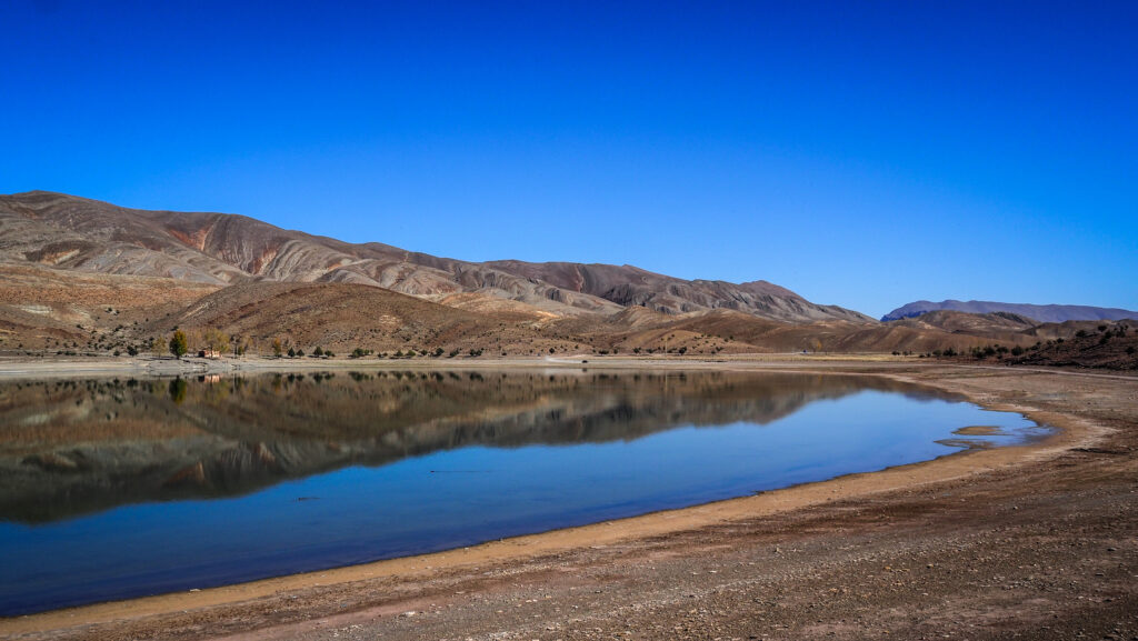
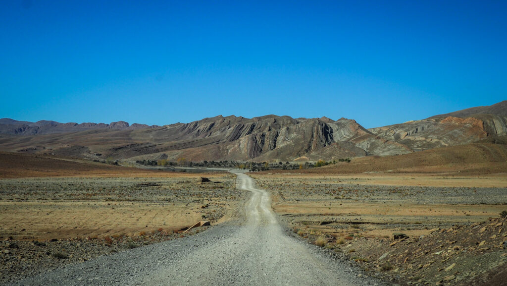
I followed the N13 road to the south, to check how far I could go with Renault Clio. The landscape changed and the terrain was more rocky, without high dunes. Soon, roadworks started and the surface turned into a combination of sand and small stones so I decided to turn back. If you have a 4X4, you can drive all the way to Zagora. It must be an amazing off-road experience!
Desert landscape en route to Ouzina
Sijilmassa Archeological Site and Rissani
From the 14th to 18th century, Sijilmassa was the desert capital and a hub for trading gold and slaves across the Sahel.
Caravans of camels left Sijilmassa for the remote desert salt mines of Taodeni and Tagahaza (modern-day Mali), then travelled to Niger and Ghana, where a pound of Saharan salt was sold for one ounce of African gold. By the 12th century, Sudanese gold purified in Sijilmassa had reached Europe and was coined into European coins.
The city collapsed in the 14th century due to internal conflict. Alawite Sultan Moulay Ismail rebuilt it in the 18th century, but it was eventually destroyed by nomadic fighters from Aït Atta.
Today, the town’s name is Rissani and it is no longer the vibrant place it once was. The 17th-century ksar houses only a fraction of the population, while the modern town consists of just one street and plaza. Few ruins of Sijilmassa remain, but you can wander around freely and use your imagination to feel the grandeur of the ancient city.
If you have some extra time, it’s worth driving about 20-kilometre loop along P7107 road through Ksar Guighlane, Ksar Tazegzout and Ksar Jdid El Ghorfa. A lot of great architecture with crumbling kasbahs, but unfortunately as soon as you leave the car, you are surrounded by “guides” who simply don’t want to leave you alone and explore in peace.
Gara Medouar
A striking rock structure that resembles a circus and serves as a natural stronghold, located at 850 meters above sea level. Although the formation appears to be a volcano or a crater, it is an eroded rock from millions of years ago.
In the eleventh century, Gara Medouar was transformed into a castle with a garrison. It probably safeguarded the trade routes from the south as well as the surrounding trading city of Sijilmasa, which produced gold coins. In the seventeenth century, the stronghold was abandoned. Portuguese prisoners of war were housed in Gara Medouar throughout the 1800s. This is how the “Portuguese Prison” gained its moniker. The inmates were made to labour in the quarries and mines in the area. Many of them passed away from illness or fatigue.
Gara Medouar is located 7 km west of the town of Rissani. Look for the turn-off from well-maintained N12 and follow the last 3 km on a gravel route to reach the slope. In optimal weather conditions, it’s possible to reach the place in a 2WD car. Just drive carefully!
Imilchil is a small village located in the Atlas Mountains of Morocco, specifically in the High Atlas range. It is best known for its remote beauty, the annual Imilchil Marriage Festival and two beautiful lakes nearby: Tislit and Isli. The town sits at a high altitude, around 2,200 meters (7,200 feet) above sea level, making it a cold, rugged, and mountainous region. Winters can be harsh with snow, while summers are more temperate.
The village is most famous for its marriage festival, an annual event held in September. Historically, it was a time when young men and women from Berber tribes in the region could meet and choose partners, with their families’ approval. Today, visitors can witness traditional Berber customs, music and dancing. It’s a great opportunity to immerse yourself in local culture!
The festival has its roots in the story of two star-crossed lovers from opposing tribes, Isli and Tislit, who were forbidden from marrying. Their grief was so deep that they cried themselves to death, forming the two lakes near the village. As a result, the festival was established to celebrate love and marriage.
How to get there?
From Major Cities
Marrakech to Imilchil (around 300 km / 7-8 hours):
The most common route is by car or bus. You would first drive towards Beni Mellal (about 3-4 hours from Marrakech) and then continue towards Ait M’hamed and Tilmi before arriving in Imilchil. This route will take you through beautiful valleys and mountain roads.
Alternatively, you can take a bus or shared taxi from Marrakech to Azilal, and from there, you may need to arrange private transport to Imilchil.
Fes to Imilchil (around 270 km / 6-7 hours):
You can travel via Midelt, a town located on the national road between Fes and Imilchil. From Midelt, you drive through the High Atlas Mountains via Ait Hani to reach Imilchil. The road is scenic but winding and steep, so be prepared for a rugged but rewarding journey.
Shared taxis and buses can take you as far as Midelt or Rich, but a private taxi or car hire is needed for the final leg.
Ouarzazate to Imilchil (around 240 km / 6-7 hours):
From Ouarzazate, you would drive towards the town of Skoura and continue via Boumalne Dades and Tamtatoucht before reaching Imilchil. This route involves crossing mountain passes and offers beautiful views of gorges and valleys.
Some buses may travel this route to nearby towns, but again, private transportation is often required to complete the trip.
Transportation Options
By Car
Renting a car is the most flexible and comfortable option. It allows you to stop along the way to enjoy the scenery and small Berber villages. The roads are generally good but can be narrow and winding, especially as you climb into the mountains.
By Bus
CTM and other bus companies offer services to nearby towns such as Beni Mellal, Midelt, or Rich. From these points, you will likely need to hire a private taxi or take a shared taxi (called “grand taxis”) to reach Imilchil. Bus travel is the cheapest option, but it can be slower and less flexible than driving yourself.
By Shared Taxi (Grand Taxi)
Shared taxis are common in Morocco and can be a more affordable alternative to renting a private car. They usually operate between major towns like Azilal, Beni Mellal, Midelt, and smaller villages. These taxis can be crowded and may not always offer the most comfortable ride, but they are a good way to travel if you don’t want to drive.
The best time to visit
The best time to visit Imilchil and the surrounding lakes Tislit and Isli is typically from late spring to early autumn, especially from May to September.
May to September offers the most comfortable weather, as temperatures are mild, and the risk of snow in the High Atlas Mountains is lower.
Summer (June to August) can be ideal because of warmer temperatures in the region, though it remains cooler compared to lower elevations in Morocco due to the altitude.
Autumn (September to October) is also pleasant, especially during the famous Imilchil Marriage Festival in late September.
Winters (November to March) are very cold in Imilchil, with heavy snowfall and harsh conditions, making travel and outdoor activities more difficult.
Lake Tislit
How long to stay there?
Half a day is enough to comfortably explore the area of the lakes. There is nothing much to do in the town itself other than having a cup of tea and observing local life going on.
Visiting Lakes Tislit and Isli
Lake Tislit and Lake Isli are situated near the village of Imilchil, at an altitude of over 2,000 meters. The lakes are relatively close to each other (8 kilometres) but are in separate basins, surrounded by rugged mountain terrain. Their high-altitude setting makes the area cold in winter, with snow often covering the surrounding peaks.
The road to Lake Isli
Lake Tislit (often referred to as the “Bride’s Lake”) is smaller and more rounded, while Lake Isli (the “Groom’s Lake”) is larger and more elongated. The lakes are fed by rain and snowmelt from the surrounding mountains, and the area around them is relatively dry, with limited vegetation apart from seasonal grasses and small shrubs.
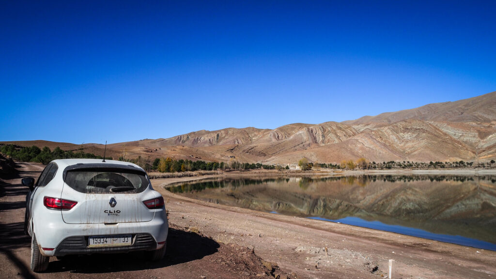
In the beginning, I had no idea that there were actually two lakes. When I reached Lake Tislit, I immediately saw some other dirt road and quickly checked on the map where it was going. Then, I discovered Lake Isli. I wasn’t very sure about road conditions and I was hesitating if driving in Renault Clio was a good idea but I’m happy I took that risk. In dry conditions, the road is quite easy and doable in 2WD. If you are adventurous and looking for a calm place in nature, these are the spots for you!
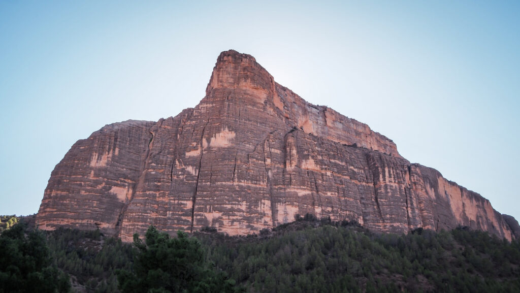
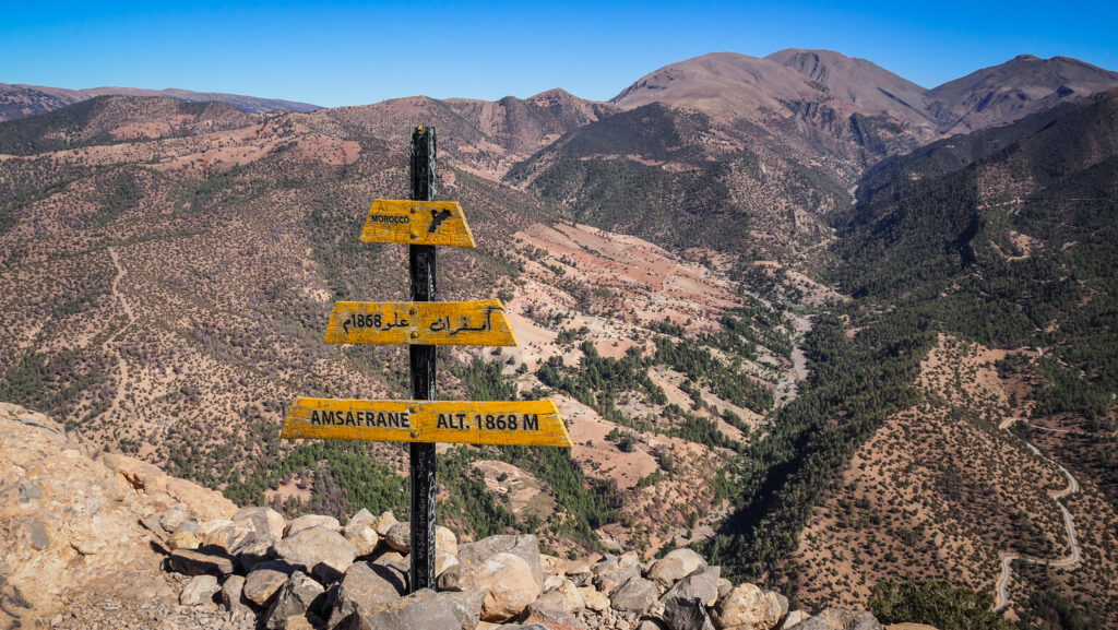
Imsfrane Cathedral has nothing to do with a religious building but it is a striking natural rock formation that rises to 1872 meters above sea level. The term “Cathedral” in this context is used metaphorically to describe the towering and majestic appearance of this rock, which resembles the shape of a cathedral with its steep, vertical cliffs. The rock formation is a popular destination for hikers and nature enthusiasts due to its dramatic geological features.
How to get there?
By Car
From Marrakech, take R210 heading northeast toward Demnate and then continue to Ouaouizeght on R304. It’s going to be about 4 hours drive (216 km). From Ouaouizeght, it’s another 57 km, which takes about 1.5 hours due to the bad condition of the road (doable in a normal car like a Renault Clio).
From Zaouiat Ahansal, take R302 for 43 km. It’s a dirt road so you should count about 1,5 hours to cover that distance.
By Bus/Taxi
You can take a bus from Marrakech to Demnate. Bus companies like CTM operate this route, and the journey takes 2.5 to 3 hours. For further connections, you must ask locals or negotiate the ride with taxi drivers. Be prepared for a long and tiring day.
The best time to visit
Plan your trip in spring or autumn for the best weather conditions. Winter can bring snow and ice to the higher mountain roads, making them difficult to navigate. Summer can be hot, but temperatures are milder in the mountains.
You should always have some warmer layers, regardless of the season. In the end, it’s mountains there!
How long to stay there?
Half a day is enough to get to the top of Imsfrane Cathedral or even do a longer loop. If you want to explore a bit more or at a slower pace, plan one full day.
Where to stay?
If you decide to spend a night in the area, there are some basic options such as Auberge à la Cathedrale Imsfrane or Gîte D’étape La Cathédrale.
The hike to Imsfrane Cathedral
I left early from Zaouiat Ahansal and had a first good look at the rock from the viewpoint “Vue panoramique sur la cathédrale” just on the roadside. You may find it on Google Maps. It looked truly impressive and I was looking forward to standing on top!
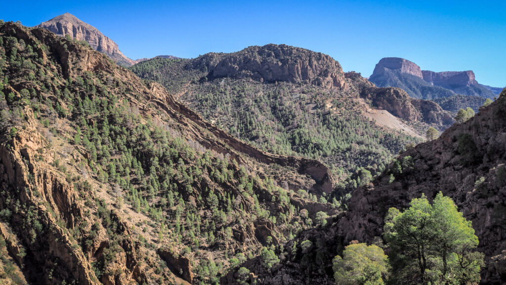
I parked the car just next to Gite La Cathedrale, packed water and hit the trail. I recommend using Mapy.CZ as the trailhead isn’t clearly marked. The plan for that day was to do a loop, including the summit of Imsfrane Cathedral, and returning through Ahansal Gorge. The total distance of 15.2 kilometers.
The mornings in this region can be cold but as soon as I started the ascent, I had to remove some of my layers. It was already getting quite hot, therefore I took off my thermal underwear and continued going up. The trail was obvious and there were also some other people around, so I felt perfectly safe.
First views while going up
The views were nice and soon I passed a group of goats. It’s crazy how they climb these steep rocks. At some point, there was a short small section which was a bit steeper and I thought it was the beginning of a more difficult climb but it wasn’t. The path flattened again and it was steadily climbing on the side of the rock.
Finally, I reached the summit and there was only me and a local vendor. The views were breathtaking! I also felt that I wanted to appreciate the fact that the guy came up all the way to sell hot tea, drinks and snacks so I bought a juice and a pack of walnuts.
At the top of Imsfrane Cathedral
On the way down, I took a different path, on the other side of the mountain. I was descending quickly and this path seemed to be less popular as I met only two other people going in the opposite direction. Once I reached the crossroads, I decided to turn right and head towards the Ahansal Gorge. Unfortunately, it was not exactly what I expected as instead of going down to the canyon, the trail took me to a viewpoint. Well, the view wasn’t bad at all.
The view to Ahansal Gorge
I returned the same way and took another trail heading down to the canyon. Unfortunately, there was another obstacle – a fast fast-flowing stream to cross! I didn’t want to get my shoes wet, nor did I want to cross it barefoot. I somehow managed to move forward on the edge of the rocks but when I thought the worst was behind me, then again I reached the point where crossing the stream was the only solution. I just did it without taking off my shoes. Better safe than sorry!
Imsfrane Cathedral
Soon I joined the main road that I was driving on in the morning. The last meters to the car were quite boring and felt really long. There was absolutely no traffic so I couldn’t catch a ride. I passed by a popular photo spot that I have seen many times on Instagram, with a ruined car.
Finally, I reached my car, bought some chips and tonic in the nearby shop and started driving towards Ouaouizeght. The hike to Imsfrane Cathedral was beautiful and it was a time well spent in nature!
The Ait Bouguemez Valley, often referred to as the “Happy Valley,” is located in the Central High Atlas Mountains of Morocco. It is situated at an elevation of around 1,800 to 2,000 meters above sea level, providing cooler temperatures compared to the surrounding lowlands.
The valley is home to the Ait Bouguemez Berbers, an indigenous group with a rich cultural heritage. The local language is Tamazight, a Berber language. Traditional ways of life are well-preserved here, with agriculture being a primary occupation. The valley is known for its walnuts, apples, and barley crops.
Visitors often hike to nearby peaks such as M’Goun (4,071 meters), the second-highest mountain in Morocco. Moreover, the valley offers opportunities for cultural immersion, including homestays and interactions with local communities. Other notable attractions include the dinosaur footprints near the village of Ibaqalliwn, and the ancient granaries, or “igherm,” used by the Berbers for storage.
How to get there?
To get to Ait Bouguemez Valley, you have several options depending on your starting point and preferred mode of transport:
By Car
The best option is to rent a car either in Marrakesh. There are several interesting places to see en route and the landscape of the High Atlas Mountains is extremely scenic. The distance to Ait Bouguemez Valley is about 180 kilometres (4 – 5 hours).
If you drive from Ouarzazate, it is 222 km (5,5 – 7 hours). The landscape around the road R307 is very beautiful! Fuel stations and amenities become sparse as you get closer to the valley. Ensure your vehicle is well-fueled, and carry enough water and snacks.
By Bus
First, take a bus from Marrakesh to Azilal. The bus ride takes about 4 to 5 hours. Several companies operate this route, and you can find buses departing from the main bus stations in Marrakesh.
In Azilal, you can find a grand taxi or a local minibus to the Ait Bouguemez Valley. This part of the journey takes about 2 to 3 hours. Taxis and minibuses are available near the bus station in Azilal.
The best time to visit Ait Bouguemez Valley is spring (March to May) and autumn (September to November). The weather is pleasantly warm, with daytime temperatures ranging from 15°C to 25°C. This makes exploring villages, hiking, and enjoying outdoor activities comfortable. Autumn is also a harvest time for apples and walnuts, offering a chance to experience local agriculture practices.
Summers can be scorching, with temperatures often exceeding 30°C. While some travellers can handle the heat, it may be uncomfortable for extended outdoor activities. Winters are cold with occasional snowfall. Daytime temperature ranges from 0 C to 15 C. The valley can be very picturesque under a blanket of snow, but some trails and roads may be inaccessible or challenging due to snow and ice.
You should always have some warmer layers, regardless of the season. In the end, it’s mountains there!
How long to stay there?
One day is enough if you just plan to drive through the valley with a few photo stops. However, I highly recommend staying overnight in one of the local homestays and planning at least a few hours hike in the area.
Where to stay?
I spent the night in La Montagne Au Pluriel in Agouti village. The room was cosy and the shared bathroom facilities were clean with ample hot water. The owner was very helpful and offered advice on where to explore the surrounding area. He can also organize a guide for longer treks, e.g. to Mount Goun. I ate breakfast and dinner there and the food was delicious and traditional.
Ait Bouguemez ValleyAit Bouguemez Valley
What to do in Ait Bouguemez Valley?
Trekking
Ait Bouguemez to Timit
I did a half-day trek, starting at my accommodation in Agouti. The morning was so cold that I even wore my thermal underwear but as soon as the sun rose from behind the mountains, it got really hot!
I turned right, crossed over the river and then turned left, following a dirt road surrounded by apple orchards. It’s about 7,5 km (1.5 – 2 hours) to reach a viewpoint in Timit where the ancient granary is located. The views around it are splendid and for a few dirhams, you can go inside and on its roof.
I returned to La Montagne Au Pluriel following an asphalt road. The total distance of the hike was 13 kilometers and it took me about 4-5 hours.
Ait Bouguemez to Ikiss
Another hike option would be heading south towards Ait Said and further through Arrouss to Ikiss. From Arrouss, the path winds its way south through a beautiful gorge, with some nice wildflowers usually lining the route. Once the path leaves the gorge you find yourself at one end of some wide open fields. Monitor the time and your position on Mapy.CZ and turn back to return to Ait Bouguemez the same way. The distance to the Berber village of Ikiss is about 9 kilometres one way.
This section of the hike corresponds to the first day of the ascent to Mount Goun.
Mount Goun
The biggest hiking challenge in the region is definitely Mount Goun. Standing at about 4,071 meters, it is the third-highest peak in North Africa.
There are various routes to the summit, with the standard route passing through the Tarkeddit Plateau. The trek is considered moderate to challenging. It involves high-altitude hiking, and trekkers should be in good physical condition and acclimatized to altitude.
The best time to trek Mount Goun is from May to September when the weather is more stable and the trails are clear of snow. However, weather conditions can change rapidly in the mountains, so it’s important to be prepared.
Guided treks usually take 4-6 days and the best is to find a local guide directly at Ait Bouguemez instead of using the services of travel agents from Marrakesh. It will save you a lot of money, even though you need to arrive at Ait Bouguemez at your own cost. The guide will provide you with food, tents, mules, and muleteers.
For other hiking options, please ask about at your accommodation. Locals have the best knowledge of where to go!
Ait Bouguemez ValleyAit Bouguemez ValleyAit Bouguemez ValleyAit Bouguemez ValleyAit Bouguemez Valley
Dinosaur Footprints
Nothing indicates the presence of the site from the road so it’s a bit hard to find. You need to go behind the houses and it feels like walking into someone’s backyard. Most likely some locals will show you the way for a few dirhams. The rural experience is more fascinating than the tracks themselves, although it really feels like touching the history.
Lac Izoughar
Most likely the lake will be without water, but the views with nearby peaks are well worth it. It’s an easy trek of about 1 hour from the town of Zawyat Oulmzi, starting from the vicinity of Gite Touda.
Tizi N’ Tighist Conservation Center
This museum is located at the foot of Mount Rat and preserves rock inscriptions dating back to more than 2500 years BC. Look for “Tizi N’ Tighist conservation des gravures rupestres de Jbel Rat” in Google Maps.
Tizi n’ Tirghist
You need to go over this pass with an elevation of 2.628 meters above sea level to reach the road R302. Before driving up, make sure the weather conditions are favourable.
Iminifri Natural Bridge
Amazing geological formation located near the town of Demnate. It is a natural rock arch that spans a river, created through the erosive forces of water over a long period. There are steps down on both sides so you can easily make a half an hour loop hike. Good footwear is recommended but you can skip the guide services.
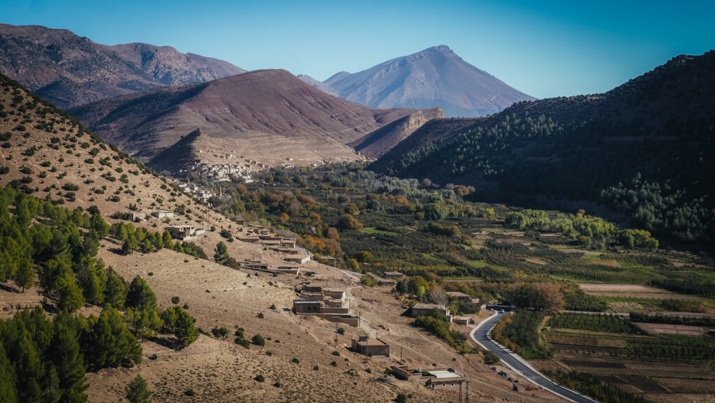
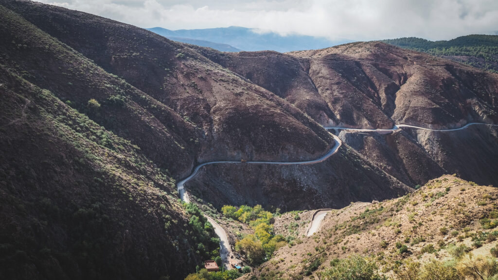
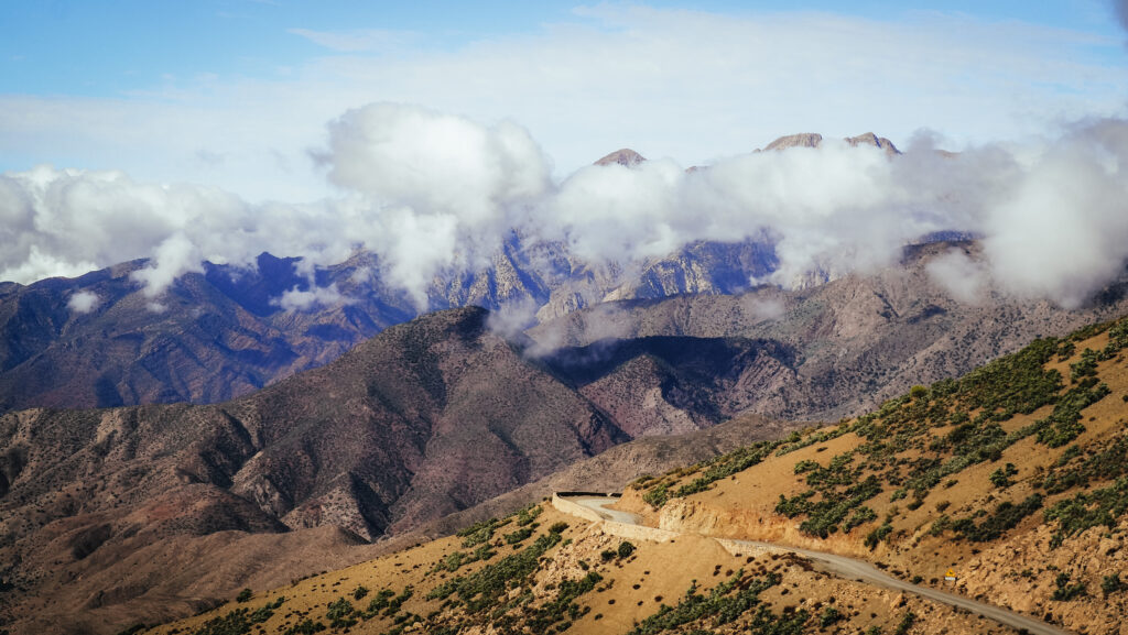
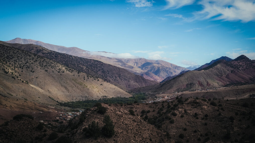
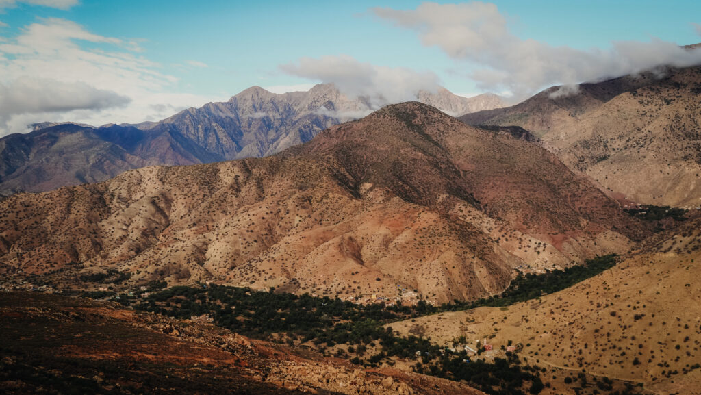
Tizi n’Test is a mountain pass located in the High Atlas mountains, that connects the cities of Marrakech and Taroudant via a scenic but challenging route. The pass is at an elevation of approximately 2,092 meters above sea level.
It has been a critical route for centuries, used by traders and travellers moving between the northern plains and the southern regions of Morocco. The area is rich in Berber culture, with many traditional Berber villages that can be visited along the route.
The Tizi n’Test area is geologically active and subject to seismic events due to the region’s tectonic activity. The High Atlas Mountains are situated on the boundary between the African and Eurasian tectonic plates and this tectonic interaction creates fault lines and seismic activity.
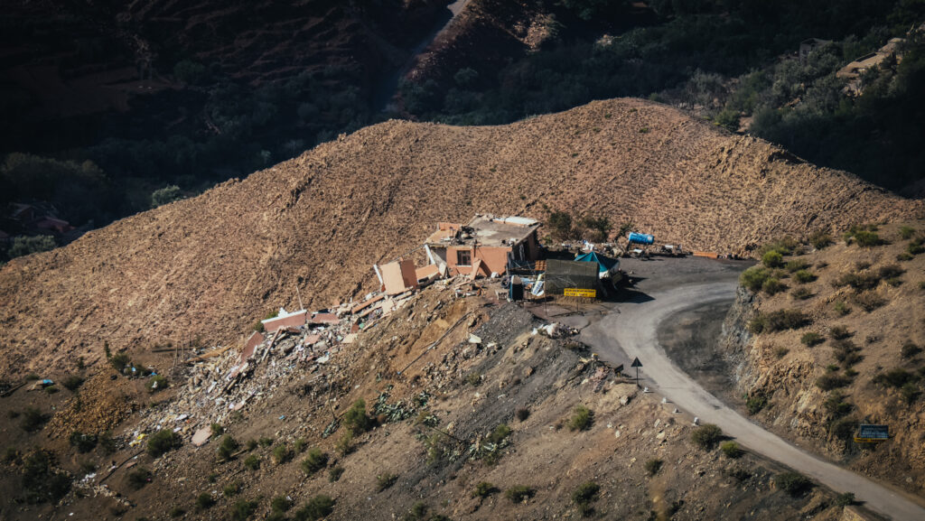
September 2023 Earthquake
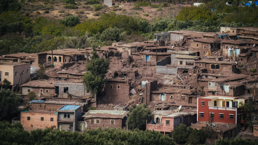
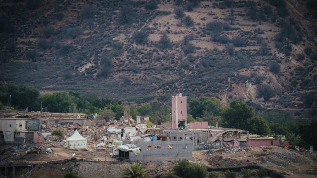
A strong 6.8-magnitude earthquake occurred in Morocco on September 8, 2023. The epicentre was roughly 72 kilometres southwest of Marrakech, close to the town of Oukaimedene in the High Atlas Mountains. This earthquake occurred at a shallow depth of 18 kilometres, resulting in strong surface shaking that was felt over a wide area, including Casablanca, Portugal, and Algeria. Significant damage was wrought by the earthquake, especially in the province of Al Haouz and the neighbouring High Atlas area. Over 2,900 people lost their lives and over 5,500 were injured as a result of it. Buildings collapsed and infrastructure was damaged in numerous isolated mountain settlements, making rescue operations difficult. Marrakech’s historic neighbourhoods also sustained significant damage.
About 20 minutes after the initial earthquake, an additional 4.9 magnitude aftershock occurred, making rescue and relief efforts much more challenging. The level of destruction and the difficult terrain presented major obstacles to the Moroccan government’s and foreign aid organizations’ massive attempts to deliver relief to the impacted populace.
Destruction along Tizi n’TestDestruction along Tizi n’TestDestruction along Tizi n’TestDestruction along Tizi n’Test
How to get there?
The best option is to rent a car either in Taroudant, Marrakesh or Agadir. The landscape is phenomenal and it’s good to be independent and travel at your own pace. I did the drive in a Renault Clio so a 4×4 vehicle is not necessary.
If you decide to start from Agadir, I recommend using the service of Click’n’Go Car Rental. Amiable guys and easy to contact on WhatsApp. I rented a Renault Clio for the whole month and got a nice price.
Not having a car will make a trip significantly longer and less comfortable. Most likely you will need to take local minibuses or hitchhike but there is not a lot of traffic.
The best time to visit
The best time to drive Tizi n’Test is during the late spring, summer, and early autumn months.
Late Spring (April to June): Generally mild and pleasant temperatures. The mountains are lush with greenery and wildflowers are in bloom, making for beautiful views.
Summer (July to September): Warm to hot temperatures but cooler in the higher elevation of the pass. The road is typically clear of snow, and driving conditions are generally safe. There are fewer tourists compared to other popular destinations in Morocco, offering a more tranquil experience.
Early Autumn (October to early November): Mild and pleasant temperatures with the possibility of cooler nights. The autumn colours begin to appear, adding to the visual appeal of the drive.
Winter (December to February): Definitely to avoid. The pass can be closed due to snow and icy conditions. Even if open, the driving can be hazardous. Early spring (March) is not the best either. While the snow might begin to melt, conditions can still be unpredictable, with the possibility of lingering snow and ice on the road.
Safety
As mentioned before, I did the drive in a Renault Clio so a 4×4 vehicle is not necessary. However, always aim to travel during daylight hours to better appreciate the views and ensure safer driving conditions. Before embarking on your journey, check the weather forecast and road conditions. Weather in mountainous areas can change rapidly.
A mobile signal may be weak or nonexistent in some areas, so inform someone of your travel plans and expected arrival time. Last but not least, ensure your vehicle is in good condition, with a full tank of fuel and emergency supplies. By planning your trip during the optimal months and taking necessary precautions, you can enjoy a safe and scenic drive through the Tizi n’Test.
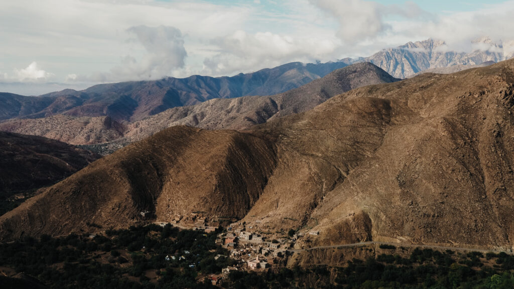
The landscape around Tizi n’TestThe landscape around Tizi n’TestThe landscape around Tizi n’TestThe landscape around Tizi n’Test
How long does it take?
The distance between Taroudant and Marrakesh is 225 km and it takes 5 hours of driving but obviously, you should add some time for stops as the views are amazing. A detour to Lalla Takerkoust will add about one more extra hour to driving time.
The drive through Tizi n’Test
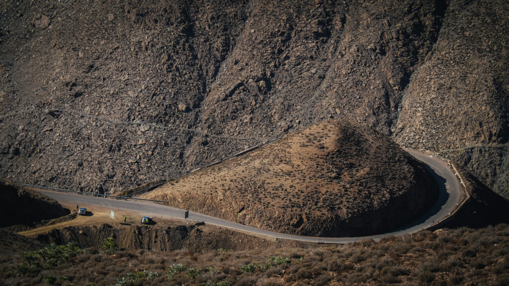
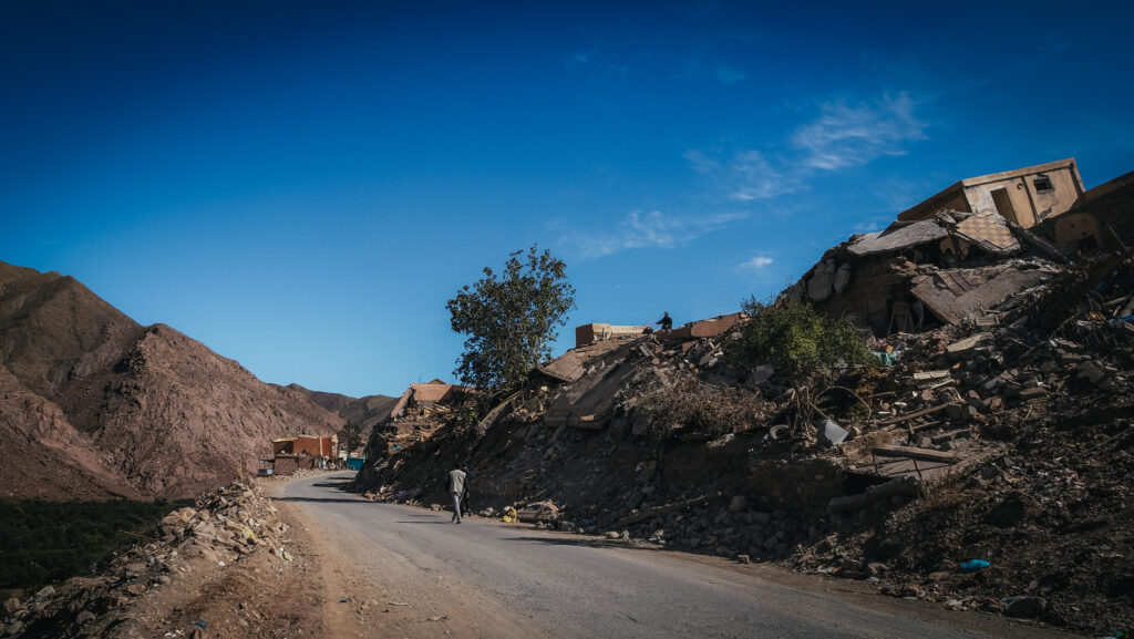
I had some doubts if driving through the pass a few days after the earthquake was a good idea, but the day before departure I had met a guy travelling on a motorcycle who confirmed that the pass was open. I left Taroudant very early in the morning and headed east towards Oulad Ali. It was October 24th, so a bit over a month since the deadly earthquake.
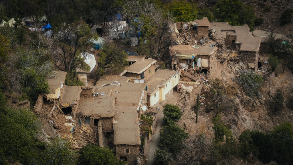
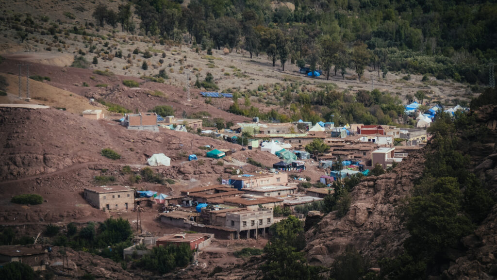
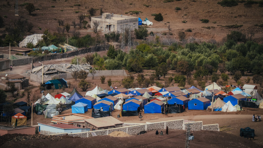
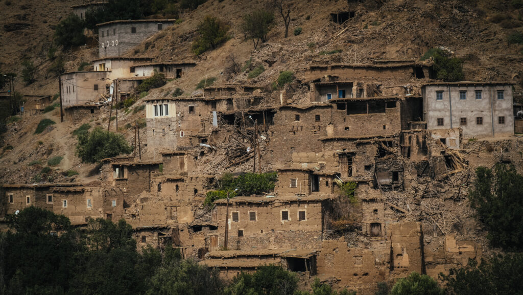
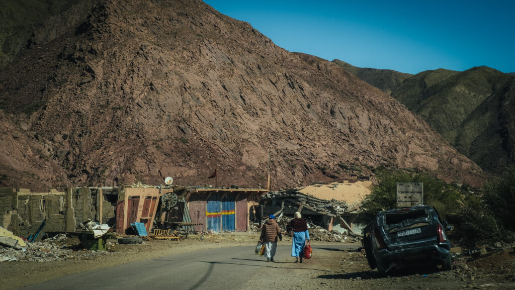
On the way there I noticed three young boys hitchhiking on the side of the road so I decided to give them a lift. They seemed to be really nice even though we couldn’t communicate in English. I made several stops to take pictures and soon I saw the first village which seemed to be destroyed by the quake. There was a lot of rubble and some collapsed buildings. I bit further were emergency tents in blue or yellow colours, providing temporary shelters for inhabitants.
Destruction along Tizi n’TestThe landscape around Tizi n’TestTemporary tentsThe landscape around Tizi n’TestThe landscape around Tizi n’Test
The way to the top of the pass was easy and soon I reached Hotel La Haute Vue. A traditional small cafe and restaurant where you can enjoy cool drinks or even spend a night if you wish to. Waking up near the top of the pass must be magical!
More interesting places and landscapes were waiting along on the descent. Near the pass is the historic Tin Mal Mosque, built in the 12th century. It is one of the few mosques in Morocco that non-Muslims can visit and is an important site in Moroccan history. It was significantly damaged during the earthquake and was off-limits for tourists.
I took many hitchhikers on that day. The most interesting was the guy carrying a huge bag full of nuts. As we reached his destination, he repacked some nuts into a smaller plastic bag and handed it to me as a thank-you gift. Very nice of him!
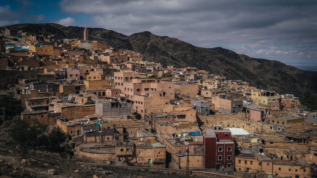
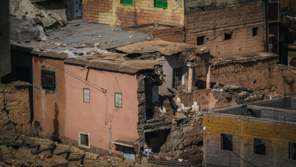
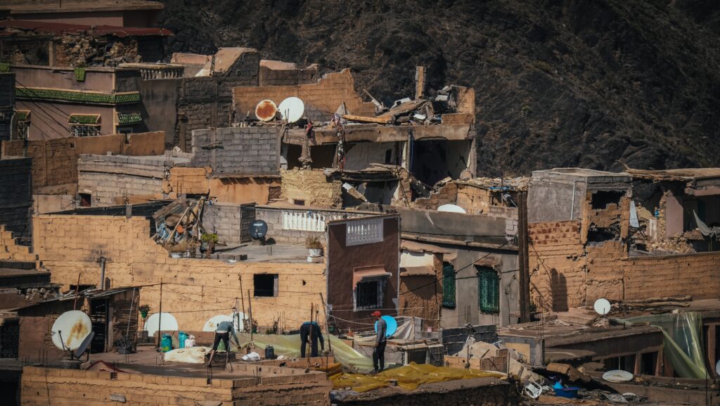
The area along the descent towards Marrakesh seemed to be the most destroyed by the earthquake, with lots of collapsed buildings emergency tents and destroyed cars. I saw plenty of police and military vehicles as well as volunteers working for World Central Kitchen and other humanitarian organizations providing aid.
Temporary tentsDestruction along Tizi n’TestDestruction along Tizi n’TestDestruction along Tizi n’TestDestruction along Tizi n’TestDestruction along Tizi n’TestDestruction along Tizi n’TestMy Brahim townMy Brahim townMy Brahim town
Local people were forced to live inside temporary tents while the temperatures at night were close to 0 C. It was a shocking view and it helped to realize how powerful that natural disaster was. The houses in that region are mostly built from clay or earth and that’s why they are so fragile to collapse.
When I passed Asni, I decided to make a detour to Lalla Takerkoust to see the lake, but the way to get there was much more interesting than the lake itself.
The lake is actually a reservoir created by the Lalla Takerkoust Dam, built during the French colonial period in the 1920s. It is a popular spot for water activities such as jet skiing, kayaking, paddle boarding, and fishing. The serene environment also makes it ideal for picnics and relaxing by the water.
Agafay Desert may not be as impressive as the Sahara, but the first impression was quite good. Lots of quads were driving around as it is a popular half-day activity from Marrakesh.
Dakhla, located on a narrow peninsula in the Western Sahara region, is a unique and increasingly popular travel destination. Its lagoon is especially famous among water sports enthusiasts, who come over to practice mostly kitesurfing and windsurfing.
Dakhla has a rich history influenced by various cultures, including Berber, Arabic, and Spanish. It was previously known as Villa Cisneros during Spanish colonial rule. Today, the town retains a mix of Moroccan and Sahrawi cultures, with traditional music, crafts, and cuisine being important aspects of daily life.
The area around Dakhla has been inhabited for thousands of years, primarily by Berber tribes. In ancient times, it was part of trans-Saharan trade routes, facilitating exchanges between sub-Saharan Africa, North Africa, and Europe.
Fishermen boats
In the late 19th century, during the Scramble for Africa, Spain established control over parts of the Western Sahara, including Dakhla. The town was founded in 1884 as Villa Cisneros, named after Francisco Jiménez de Cisneros, a Spanish cardinal. Under Spanish rule, Villa Cisneros became an important administrative and military outpost. The Spanish constructed infrastructure such as roads, buildings, and a military base.
After World War II, anti-colonial movements gained momentum across Africa. In Western Sahara, resistance against Spanish rule began to intensify. By the mid-20th century, Spain faced increasing pressure to decolonize. In 1975, following the Madrid Accords, Spain agreed to withdraw from Western Sahara, transferring administrative control to Morocco and Mauritania.
Local fishermen on the beach
The withdrawal of Spain led to a conflict involving Morocco, Mauritania, and the Polisario Front, which seeks independence for Western Sahara. Mauritania withdrew in 1979, leaving Morocco in control of Dakhla and most of Western Sahara. A ceasefire was brokered by the United Nations in 1991, but the political status of Western Sahara remains unresolved. Dakhla is currently administered by Morocco, which considers it part of its southern provinces.
Today, the Moroccan Western Sahara Wall or the Berm, which is approximately 2,700 km long, runs south to north through Western Sahara and the southwestern portion of Morocco. It separates the Moroccan-controlled areas on the west from the Polisario-controlled areas on the east.
How to get there?
To get to Laayoune in Western Sahara, you typically have a few options:
By Air: You can fly to Dakhla Airport with Royal Air Maroc from major cities, such as Casablanca or Marrakech.
By Road: The roads are generally well-maintained, but it’s a long journey, so be prepared for a drive of several hours or more depending on your starting point. If you are looking for a rental car in Agadir, I recommend using the service of Click’n’Go Car Rental. They are very friendly guys and easy to contact on WhatsApp. I ended up renting a Renault Clio for the whole month and got a nice price.
By Bus: Supratours and CTMare two popular bus companies operating in Morocco.
The best time to visit Western Sahara is during the spring (March to May) and fall (September to November) when the weather is mild and pleasant. Summer can be quite hot, while winter brings cooler but enjoyable temperatures. Choosing spring or fall ensures a comfortable climate for enjoying nearby beaches and exploring the city and its surroundings.
The city centre of Dakhla
Where to stay?
Karam City Hotel is an excellent choice. It is very well located in the city centre, close to shops, restaurants and waterfront. It has very good internet for remote work and a tasty breakfast that you can purchase additionally.
How long to stay there?
One full day in Dakhla is enough to walk around the town and try seafood. Count in extra days in case you want to practice windsurfing or kitesurfing which are extremely popular in the bay or venture out of town to the desert.
Faro de Dakhla
How to get around?
The city centre of Dakhla can be easily explored on foot, but to reach sights out of it, you will need your wheels. I rented a Dacia Duster for 2 days from Baie Car. I got in touch with them on WhatsApp and the car was delivered straight to my hotel. The price was 900 MAD for 2 days. Perfect experience!
Once driving, don’t forget your passport as you may encounter frequent police checkpoints.
My rented Dacia Duster
What to do in Dakhla?
The city center of Dakhla is not particularly nice to walk around but there are a few sights worth checking out. Several mosques serve the Muslim population: Grande Mosquée de Dakhla, Mosquée Eddarham, Mosquée du Quartier Al-Ghofrane and Mosquée Albir.
Catholic temple is present too – Iglesia de Nuestra Señora del Carmen. A small group of priests, who alternate between this church and the Cathedral of St. Francis of Assisi in Laayoune, oversee the temple. Spanish settlers constructed it for what is sometimes referred to as the Spanish Church. Nearby is a quiet park with a fountain.
Iglesia de Nuestra Señora del CarmenA park with a fountain
The other three sights are located on the outskirts of town, so you will need to take a short taxi ride to get there. Don’t forget to negotiate the price!
Faro de Dakhla is a lighthouse dating back to the Spanish colonial era. The lighthouse is a popular spot for sunset viewing and fishing with a beautiful view of the Atlantic Ocean.
Faro de Dakhla
La Sarga is a fishing village located about 15 km south of Dakhla, at the end of the peninsula. There are hundreds of fishing boats there that are towed to and from the sea by tractors. The working conditions of the fishermen are harsh and the poor housing is eye-opening. The people are friendly although the amount of rubbish all around is overwhelming and depressing view.
Oum El Bouir is a relatively nice sandy beach which is the nearest one to Dakhla city centre.
What to do out of town?
The whole peninsula is famous among water sports enthusiasts and you will see plenty of shops or resorts offering courses of kitesurfing or windsurfing. It’s an excellent place to learn new sports or improve your skills.
Trouke 25 Beach is a good spot to chill with the view of Dragon Island and big parking with plenty of campervans. It is possible to walk all the way to the island during low tide but be careful and check the tide times before you set off as you don’t want to be stuck on the island overnight. Fishermen come over here to collect various seafood from the seabed.
A view of Dragon Island
The White Dune is probably the most popular natural tourist attraction in Dakhla and can be seen in every travel brochure. It is reachable by 4WD through a dirt road cutting across the desert, but if you are ready to walk, you can get there even without 4WD as I did.
From the main road, turn right into a dirt road leading to Paraiso Dakhla Hotel. Drive as far as you can and then simply park the car on the roadside and continue on foot. You may want to use the mobile app MapyCZ for navigation as it shows all the paths in that area. It is possible to turn the hike into a pretty long loop, going back to the car through a desert and not along the coast. Don’t forget the water!
At low tide and from the distance, the White Dune looks like an island. First, I climbed it and then went down again to take some pictures from a different perspective. It was windy but absolutely breathtaking!
The White DuneWalking towards the White DuneA desert on the way to the White DuneA desert on the way to the White DuneA dirt road towards the White Dune
PortoricoBeach is a beautiful place, with a huge bay and a desert that falls directly into the sea. It was so windy that I ended up with sand all over my face. The way down there is a bit bumpy but doable in 2WD with higher clearance. There is a military post but the guards were friendly and greeted me with smiles.
Portorico BeachPortorico Beach
The Tropic of Cancer passes through eight countries in Africa, namely Egypt, Libya, Chad, Niger, Algeria, Mali, Mauritania and Western Sahara. You will spot an information board about 5 kilometres south from the turn-off to Portorico Beach.
The Tropic of Cancer
Imlili Desert was definitely a highlight of my trip. I turned left from the main road, about 55 kilometres south of the Dakhla Roundabout. The target was to reach Imlili Sebkha which is a salt flat with over 160 permanent holes of hypersaline water containing fish. Unfortunately, the pools are not signposted and I wouldn’t risk going there without 4X4.
For the first few kilometres, the road was in excellent condition but then the asphalt finished and I hit the dirt. It was possible to continue further until I reached a very sandy section. I didn’t pass any other cars on the way there and when I looked around I didn’t see anyone either. As my car wasn’t 4X4, I decided not to try my luck. I parked Duster on the roadside and continued on foot to the nearby hill.
The panorama of the Imlili Desert was magnificent even though it was very windy. I felt some regret that I couldn’t continue driving further but I knew that turning back was the only sensible thing to do. I didn’t even have a mobile signal!
As the alternative to self-driving, the Imlili Desert can be visited as a part of an organized 4X4 tour, however, it won’t be cheap. Ask about it at your accommodation in Dakhla and they will provide you with the latest offers and prices.
Imlili DesertImlili Desert
If you continue further south towards the border with Mauretania, you will pass Imlili Town and most probably another police patrol. A police officer asked me where I was heading but luckily a very simple answer that I was just sightseeing and driving around satisfied him. About 7 kilometres after Imlili, watch out for a turn off to the right, into an asphalt road. It goes to CandelariaBeach which is another secluded place with a small military camp. Soon after the turn-off, on your left you will spot huge salt flats, so don’t hesitate to park the car at the roadside and walk around to take some pictures. On the right, you can climb the dunes for the magnificent ocean view.
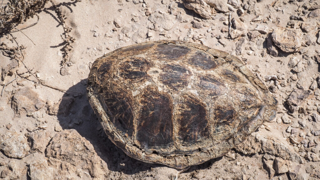
Salt flats on the way to Candelaria BeachLong and empty Candelaria BeachSea turtle shell
Candelaria Beach was the southernmost point that I visited in Western Sahara. I saw plenty of tourists travelling towards the border with Mauretania in their campervans and it was tempting to do the same, even by hitchhiking. Hopefully one day I will be able to get to that country too!
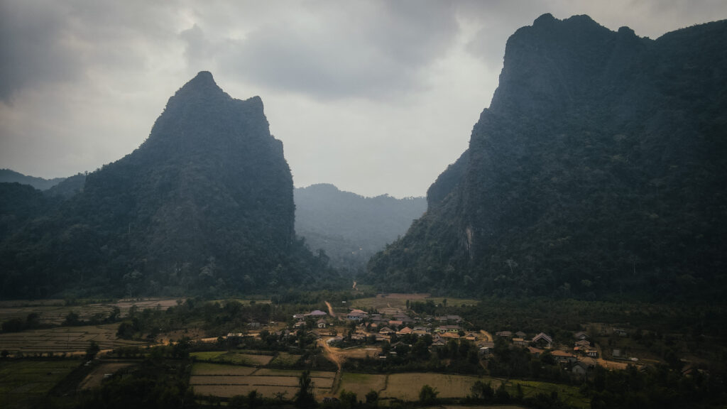
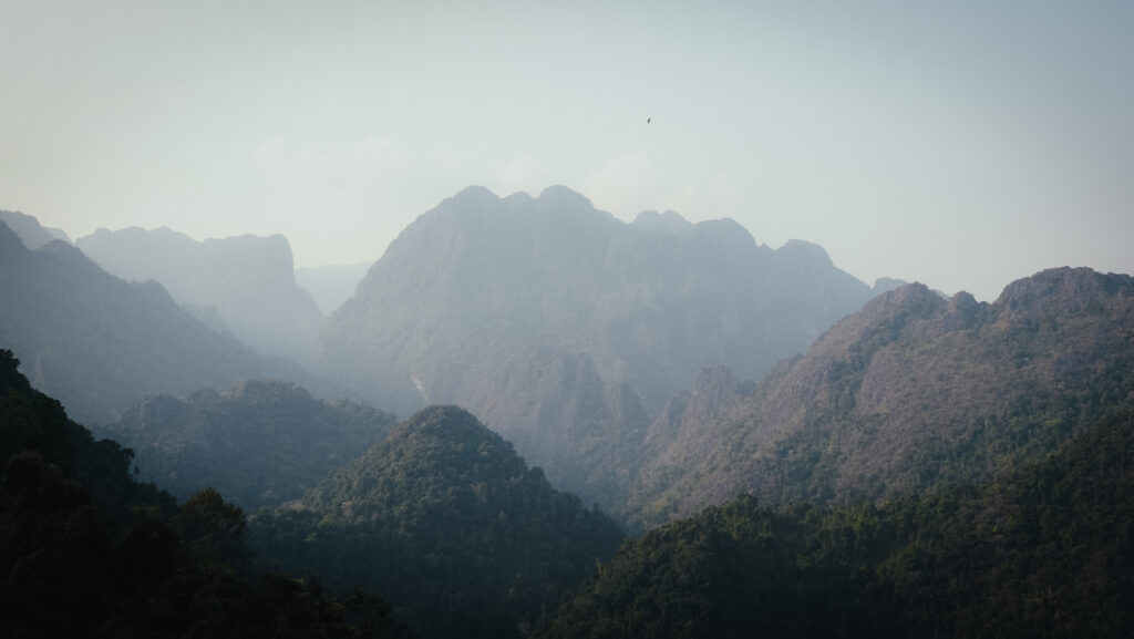
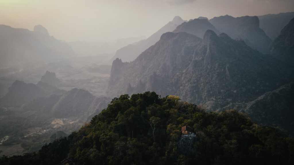
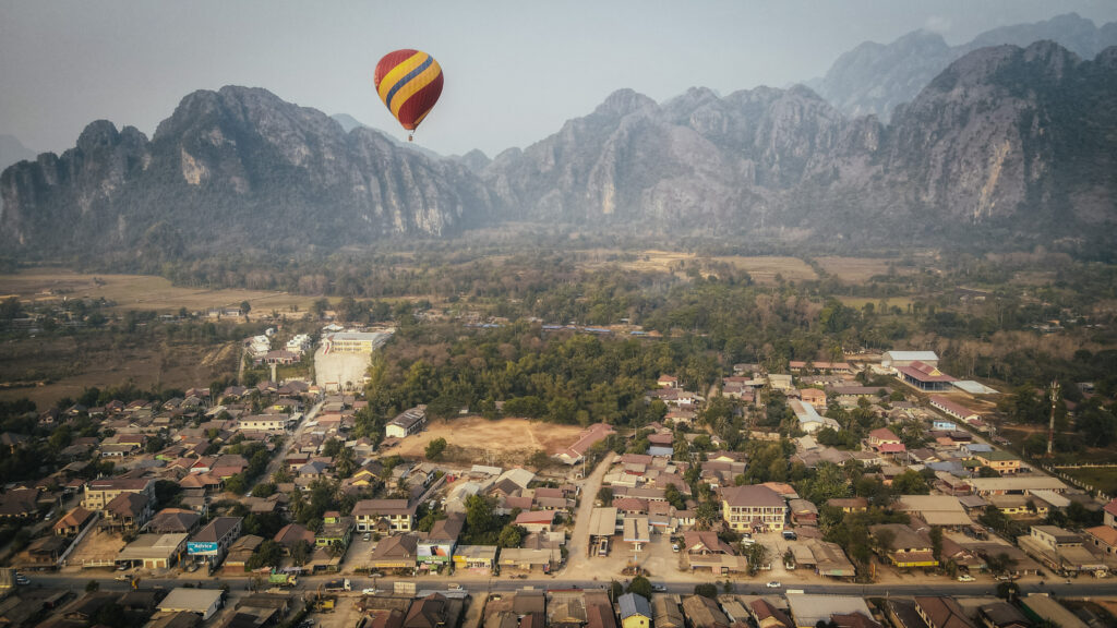
Vang Vieng is a popular tourist town in Laos, located about 150 kilometres north of the capital, Vientiane. It’s known for its stunning natural landscapes, which include limestone karst hills, caves, and the Nam Song River.
The town is famous for its outdoor adventure opportunities, such as tubing, kayaking, rock climbing, and hiking. The river tubing experience, once notorious for its party scene, has been reformed to be more family-friendly and safer. The area is also home to numerous caves, such as Tham Phu Kham and Tham Chang, which are popular for exploration. Hot air balloon rides are available for those who want to see the landscape from above. You definitely won’t get bored here!
When to go?
The most popular time to visit Laos is between November and April, at least if you don’t like rain as it’s the dry season. However, nothing is as easy as it seems. You won’t get wet, but it’s the time of intense agricultural burnouts with dense haze hanging over the mountains and the air quality is regularly rated as unhealthy.
I traveled to Laos in March but next time I would go at the very beginning or the end of the rainy season, so in October or May. Getting a bit wet is certainly better than breathing in all that air pollution!
How to get there?
By train
Laos-China railway is the first railway network in Laos and it’s becoming increasingly popular as it connects the major cities and towns like Vientiane, Vang Vieng, Luang Prabang and Boten. The average travel duration on the route between Vientiane and Vang Vieng is about 1 hour. It’s advised to buy the train tickets in advance to secure your seats.
By road
Regular buses run from the Northern Bus Station (Khua Din Bus Station) in Vientiane to Vang Vieng. The journey typically takes about 4-5 hours and is the most economical option.
Minivans are a bit faster than buses, taking around 3-4 hours. They depart from various locations in Vientiane, including travel agencies and guesthouses. Minivans are more comfortable and often have air conditioning.
There are also regular buses from Luang Prabang, taking around 6-7 hours. The buses depart from the Southern Bus Station.
Similar to buses, minivans are available and offer a slightly faster journey, around 5-6 hours. They also provide more comfort and air conditioning.
By air
There are no direct flights to Vang Vieng, as it does not have an airport. Travellers can fly to Vientiane or Luang Prabang and then take a bus, minivan, or taxi to Vang Vieng.
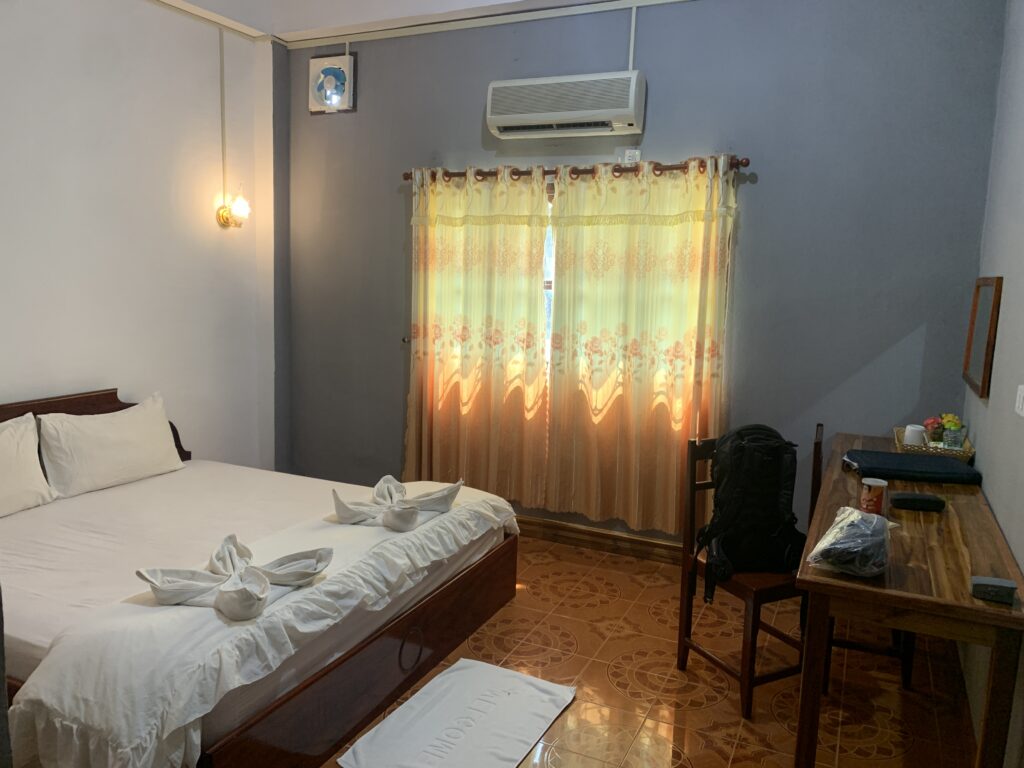
I spent two nights in Saphaothong Guesthousewhich was a good choice. The room was spacious and there was a desk for working. The reception guy was very friendly and he organized a scooter for me, although its quality was far from optimal.
The room in Saphaothong Guesthouse
How long should you stay?
I would recommend a minimum of 2-3 days to cover the sights around Vang Vieng. The countryside around the town is gorgeous and there are so many caves, lagoons, mountains and villages to explore that you don’t want to be in a hurry.
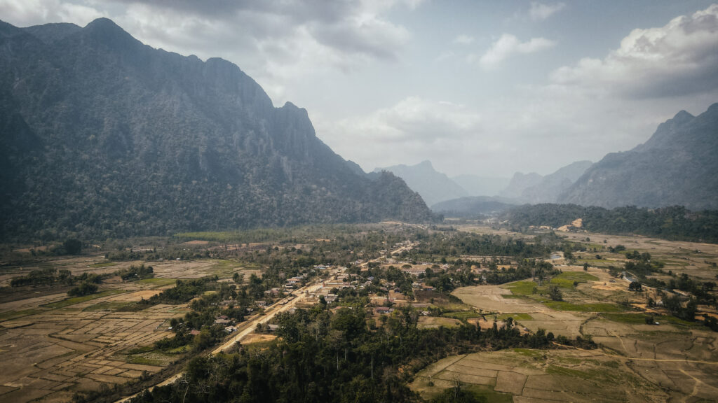
The landscape around Vang Vieng
How to get around?
The town itself is small, and many attractions, restaurants, and accommodations are within walking distance. However, for attractions outside the town centre, you’ll need another mode of transportation.
Bicycles can be rented from various guesthouses, hotels, and rental shops in town. They are fine to explore some nearby attractions like caves and blue lagoons but are definitely not suitable for longer distances or rough terrain.
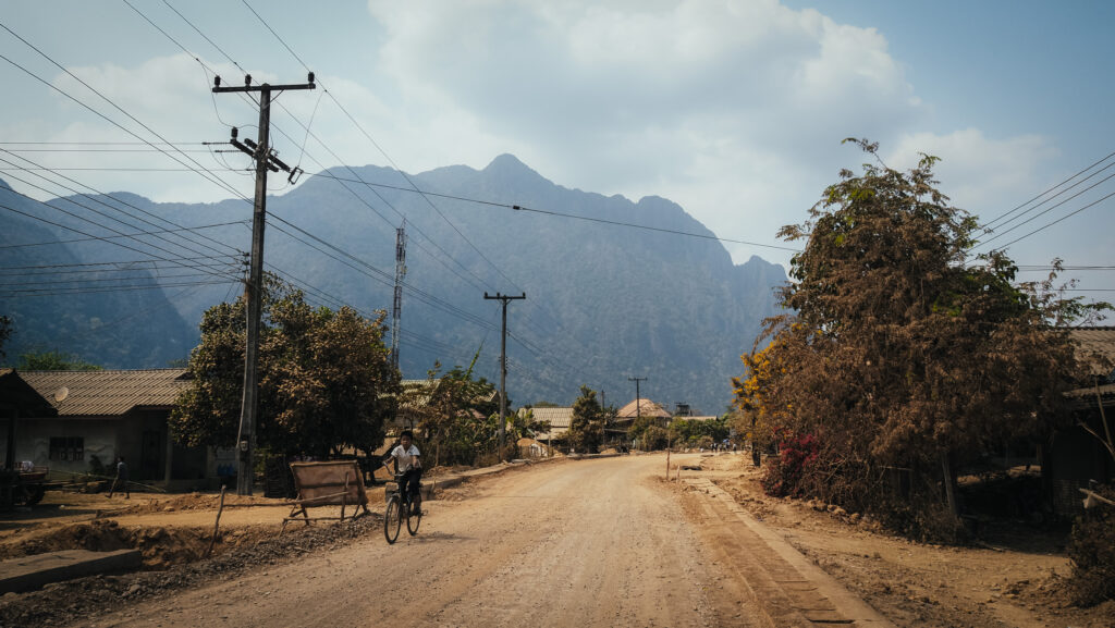
Scooters provide flexibility to explore farther and at your own pace, especially in hot weather. Don’t forget that you need a driving licence, even if no one asks you for one during the renting process. Otherwise, you won’t be covered by your travel insurance. Roads can be rough and safety gear like helmets should always be used. Also, be prepared to get dirty as most of the roads around Vang Vieng are dirt ones and every time someone overtakes you, you will find yourself in a dirt cloud.
A dirt road through the countryside
If you don’t feel comfortable riding a scooter, tuk-tuks can be easily found in the town centre and around popular tourist spots. Can be more expensive than other options, and prices often need to be negotiated.
Another alternative is to rent a buggy, especially if travelling in a group, although it also isn’t the most budget-friendly option. Moreover, check the condition of the vehicle before you hit the road as some of them look like they are going to fall apart…
What to do in Vang Vieng?
Temples
There are a few interesting Buddhist temples in Vang Vieng town centre, e.g. Wat Si Sou Mang, Wat Kang, Wat Simixay Yaram or Wat That.
Tham Chang
The most accessible of the caves in the Vang Vieng area, within walking distance from the town. You have to climb about 150 steps to get to the cave entrance. The ticket costs 20.000 LAK and the cave is very easy to explore with pathways and lights. There are also some food vendors outside selling drinks and snacks.
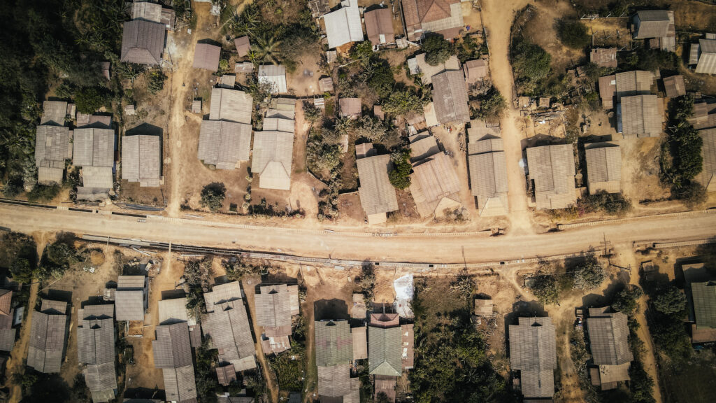
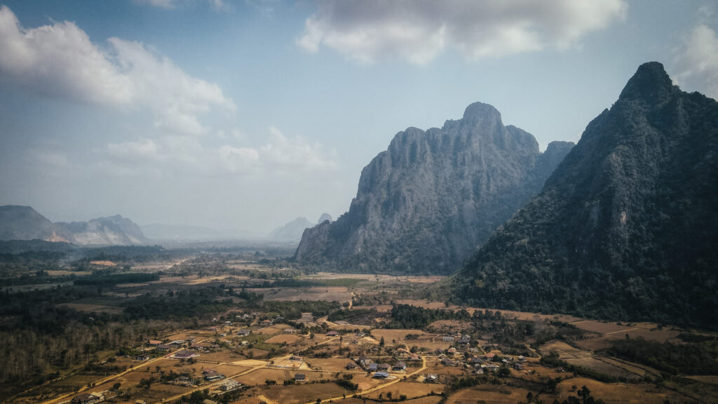
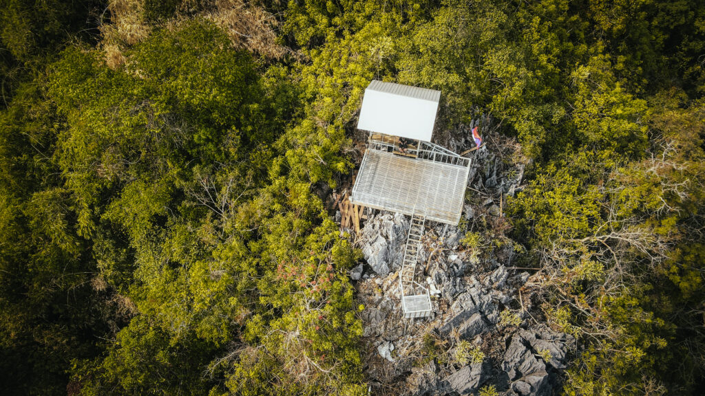
The aerial view of Ban Nampè village
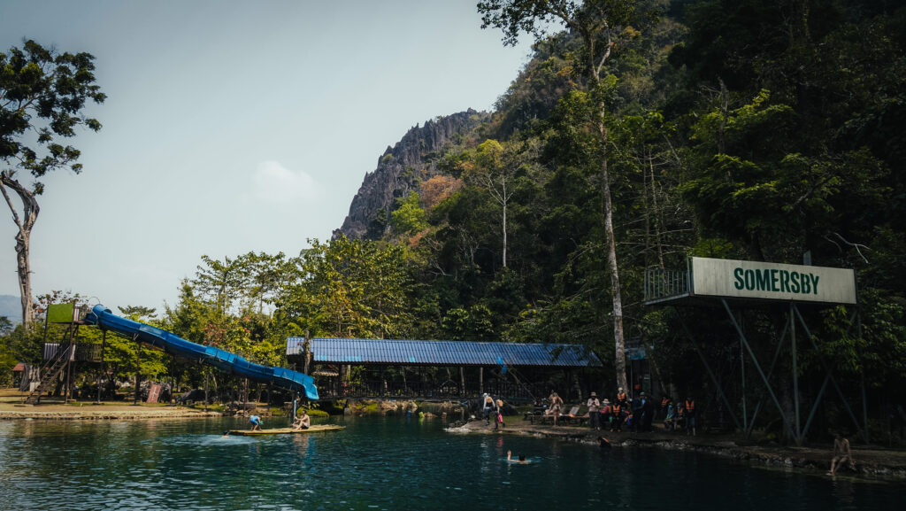
Blue Lagoon 1 and Phu Kham Cave
The busiest and most popular of the lagoons due to its proximity to Vang Vieng. There is a 5-meter jumping platform and some swings. It can get very crowded and noisy so for sure the place isn’t right for everyone, but the cave with the laying Buddha is impressive and worth exploring. You will most likely be completely alone there if you enter a bit deeper. It’s slippery inside, so bring good shoes and a flashlight is a must. You can rent some at the entrance of the cave.
Blue Lagoons 2, 3, 5
Vang Vieng is surely not short on natural springs. While some lagoons are more picturesque than others, there can be a large number of visitors, particularly at the busiest time of year. The majority of them have rope swings and jumping platforms. Besides popular Blue Lagoon 1, it’s worth visiting more distant but often less crowded lagoons numbered 2, 3 and 5. Blue Lagoon 5 is the most faraway one, however, you will ride through a very scenic village Ban Nampè, which is a great experience in itself.
One of blue lagoonsThe aerial view of a small village near Vang Vieng
Vangvieng Inter Park and Nang Oua Khiam Cave
Nice place with a swimming area and plenty of shaded rest areas. The dinosaur statues are kitschy but nature is worth exploring. I highly recommend climbing up to the cave and the viewpoint. The way to the top is definitely not 30 meters as stated on the information board and it will take you about 20 – 30 minutes to reach the observation platform. The good point is that there are hardly any tourists visiting this viewpoint so most likely you will have it for yourself. If you want to check out the cave, bring your torch!
Spectacular view from the viewpoint at Vangvieng Inter Park
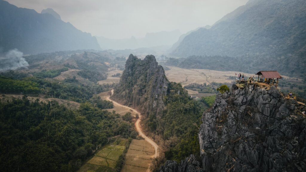
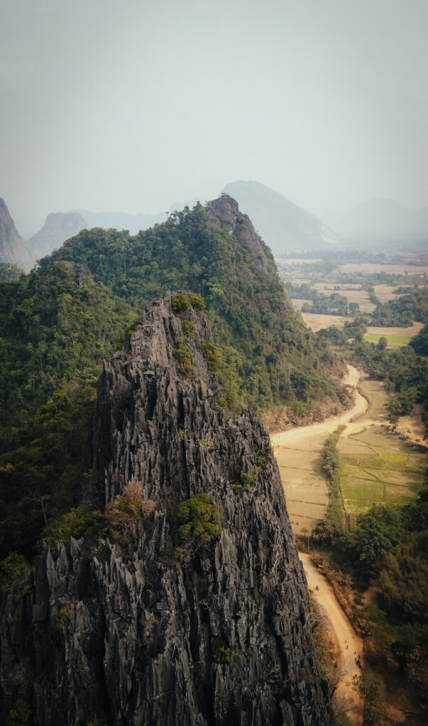
Nam Xay Viewpoint
A short but steep and sweaty hike will reward you with breathtaking 360-degree views of dramatic karst rock formations, verdant forests, and stretches of rural land and rice fields when reaching the summit. A wooden viewing deck is placed on top but feel free to explore the vista from all sides by moving around it over the rocks. Just below the summit, on both sides, are oddly positioned motorcycles, which you can sit on to get a fantastic picture!
The hike to the top takes about 30 minutes and the place can get crazily busy at sunset time.
Highly popular photo spot on Nam Xay ViewpointAerial view of Nam Xay Viewpoint
Phapoungkham Cave and Viewpoint
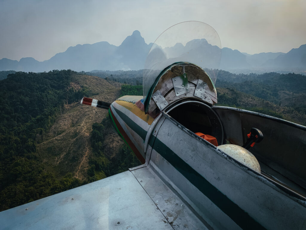
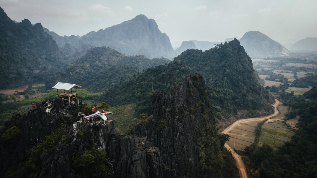
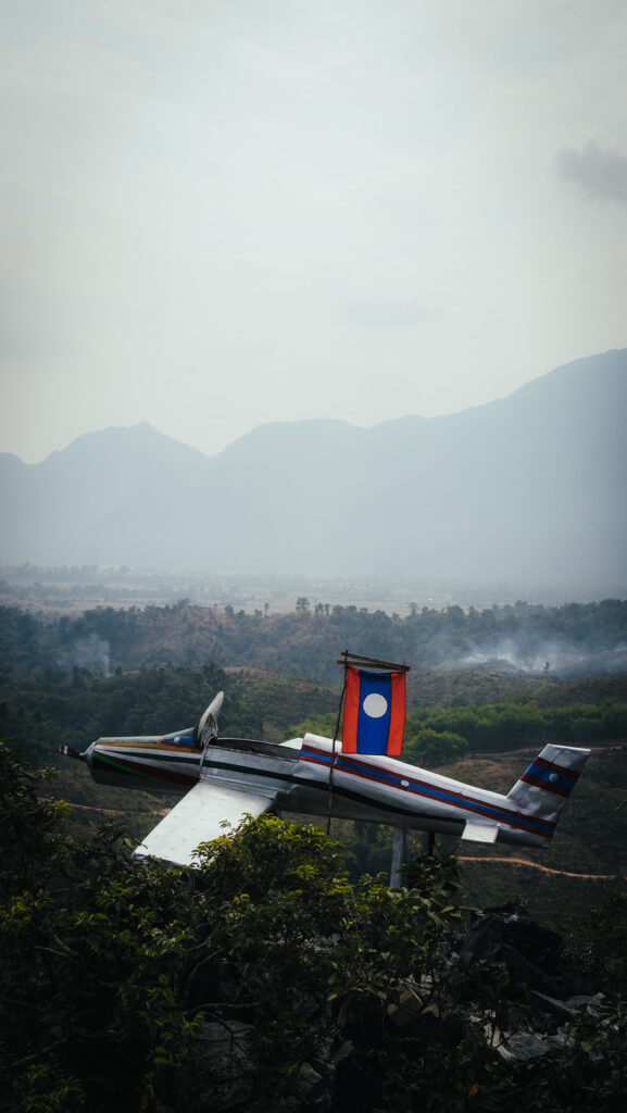
In my opinion, the best short hike and viewpoint in the Vang Vieng area. There’s a lot more to explore than just the viewpoint which makes it well worth the time and effort. You will see a cave, Buddha statues, and the aeroplane at the top. The entrance costs 20.000 LAK per person and it takes about 20-30 minutes to reach the top, mostly walking on slabs and rocks. Wear comfortable shoes. There was no one else besides me which added to the experience, especially after visiting a very busy Nam Xay Viewpoint.
Phapoungkham ViewpointPhapoungkham Viewpoint
Num Bor Keo Cave
If you’re searching for a more daring kind of cave exploring, Num Bor Keo Cave is a bit difficult to find, but well worth the effort. You will pay a 20.000 LAK entrance fee and they give you a small headlamp. The cave is more of a crawling and easy climbing experience. Sometimes you will notice yellow arrows that show you the way to go. It is a nice place to visit, but it is understandable why there are fewer tourists than in other caves in the Vang Vieng area.
Pha Ngern View Point
The physically demanding Pha Ngern hike is divided into two parts. Depending on your speed, it takes about 1 – 1,5 hours to get to the summit, with a stop at the first viewpoint on the way. Most of the trail is pretty steep so take your time and don’t forget water!
You will have to pay 10,000 LAK to enter the path. A small hut at the first viewpoint sells water, soft drinks and snacks. The views are magnificent and there was also a buggy placed on the rocks. Interesting trend to put these kinds of things on top of almost all viewpoints in Vang Vieng!
Pha Ngern View PointPha Ngern View Point
Angel Cave
A nice cave that is well lit up, and easy to walk across as there is a concrete path all the way through. You can find food and drinks right outside after you’re done with sightseeing.
Kaeng Nyui Waterfall
The place is to be visited in the wet season only, otherwise don’t expect any water. From the starting point to the waterfall is only a short walk. As of May 2024, the road to get there was under construction, so it will eventually be a really easy bike ride out there once the works are over.
Loup Cave
One of the best caves in Vang Vieng. If you travel on a scooter, you will have to pay a bridge toll of 5,000 LAK. After that, you arrive at a grassy field with a stand where you are charged 15,000 LAK to access one cave or 30,000 LAK for two of them. The caves are completely dark inside with no lights. You will be given a headlamp, but usually it isn’t very strong, so it’s better to have your own, more powerful one.
Tham Nam (Water Cave)
The most notable cave in the north of Vang Vieng. The 500-meter-long cave has an entrance from which a branch of the Nam Song flows. You can wade inside the cave during the dry season, but when the water is higher, you’ll need to borrow a tube and sit inside it, dragging yourself down the tunnel using the fixed rope. It was a truly unique experience!
Elephant Cave
There is not much to see except for the stone which resembles an elephant and a sleeping Buddha. You should be able to complete the tour in less than 5 minutes. You can stop here on the way to Tham Nam, otherwise don’t bother.
TCK Zipline
The place gets good reviews and I heard that ziplining there is incredible. The superb views and the friendly staff make the experience perfectly enjoyable.
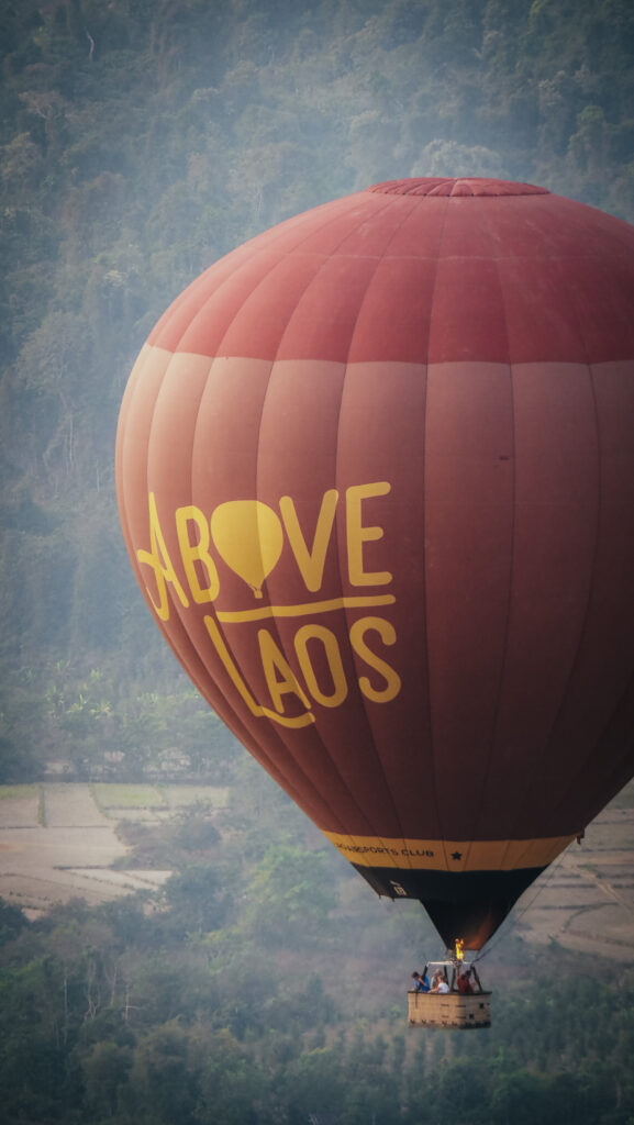
Hot air balloon
A ride in a hot-air balloon is a lovely way to see the cliffs, tapestry of paddy fields and snaking river below. Departures are at sunrise and sunset and a 1-hour ride costs 100 – 150 USD. One of the most reputable operators is Above Laos.
Mount Kinabalu is the highest peak in Borneo, standing at 4,095 meters. It is located in the Malaysian state of Sabah and is part of the Kinabalu National Park, which is a UNESCO World Heritage Site.
Mount Kinabalu is a granite massif formed about 10 million years ago. Over time, the mountain has been uplifted, and its distinctive jagged peaks have been sculpted by erosion and glaciation. The mountain is renowned for its rich biodiversity, with distinct vegetation zones ranging from lowland rainforests to alpine meadows. It is home to over 5,000 plant species, including the famous Rafflesia, the world’s largest flower, and numerous endemic orchid species. Kinabalu National Park was established in 1964 and became Malaysia’s first World Heritage Site in 2000.
Mount Kinabalu holds significant cultural and spiritual importance to the indigenous Kadazan-Dusun people, who believe that the mountain is the resting place of their ancestors’ spirits.
The first formal ascent of Mount Kinabalu was recorded in 1851 by Sir Hugh Low, the British colonial secretary on Labuan Island.
On June 5, 2015, an earthquake with a magnitude of 6.0 occurred in Ranau and lasted for 30 seconds. Since the Sabah earthquake in 1976, this was the strongest earthquake to strike Malaysia. There were eighteen confirmed deaths on Mount Kinabalu, comprising six Malaysians, two Chinese, and ten Singaporeans. After becoming stranded on the mountain, about 137 climbers were eventually rescued.
How do you get to Kundasang?
Kundasang is about a 2-hour drive from Kota Kinabalu, the capital of Sabah. You can rent a car at Hikmah Rental & Tours. Excellent contact on WhatsApp and unproblematic rental experience at a good price. The drive offers scenic views of the mountains and countryside.
Shared taxis depart from Merdeka Square in Kota Kinabalu when full. You will pay about 40 RM for a seat and the driver can drop you off at the entrance to Kinabalu National Park.
If you decide to do the hike with a travel agency, transportation by minivan will be included.
Mount Kinabalu
When to go?
The best time to climb Mount Kinabalu is generally during the dry season, which runs from March to September. There is less chance of rain, which makes the trails safer and the views clearer. The summit can be very cold at any time of the year, especially during the early morning hours when climbers aim to reach the peak for sunrise.
Bookings, permits and guides
Let me start by saying that climbing Mount Kinabalu isn’t cheap.
Several operators organize tours to the islands, but the most popular seems to be Borneo Calling. The price of a 2D1N budget hike is 1750 RM for international tourists and 1350 RM for Malaysians. They will organize everything for you: accommodation (Panalaban Hostel or Lemaing Hut), permits and guides.
If you decide to organize your hike independently, you will pay about 1600 RM for accommodation at Laban Rata. On top of that, there is an entrance ticket to Kinabalu National Park (50 RM), a hiking permit (400 RM) and a mountain guide (350 RM). If you arrive at the registration office early enough, you may be lucky to find other people to share the cost of the mountain guide with (max. 5 hikers per 1 guide).
Regardless of the option that you choose, remember that the number of permits is limited and despite the costs, it is a highly popular hike. Therefore, you must book your tour or secure a bed in a hostel a few weeks, or even months in advance.
How long is the hike?
The round trip to the summit of Mount Kinabalu is approximately 17.4 kilometres, typically takes two days and involves two main stages:
Day 1: Trailhead to Laban Rata
Approximately 6 kilometres, 4 to 6 hours with an elevation gain of about 1.400 meters. Hikers usually take a minibus to the Timpohon Gate and start hiking from there, following a well-marked trail through diverse vegetation zones, ranging from tropical rainforest to alpine meadows. The trail is steep and involves many steps. Hikers stay overnight at Laban Rata or one of the other Sutera Lodges Accommodation sites.
Day 2: Laban Rata to summit and back to the trailhead
Approximately 2.7 kilometres to the summit, plus 8.7 kilometres return to the trailhead. It takes between 2 to 4 hours to reach the summit and 4 to 6 hours for the descent. Elevation gain is about 822 meters from Laban Rata to the summit. Hikers usually begin the final ascent around 2 AM to reach the summit for sunrise. The last part of the climb involves steep granite slabs and ropes to assist in the ascent. After reaching the summit, hikers descend back to Laban Rata for breakfast before continuing the descent to the Timpohon Gate.
There is an option to spend an extra night in Laban Rata after the descent from the summit, but it will significantly increase the already high costs of the hike.
There are rest shelters with basic toilets at regular intervals.
Clouds usually roll in after 10 AM
What to pack?
Pack appropriate clothing and gear, including warm layers, waterproof clothing, and sturdy hiking boots. Overall, while the dry season offers the best conditions for climbing, careful planning and preparation can make your climb enjoyable and successful at any time of the year. Here is the list of some essentials:
Fleece or insulated jackets
Waterproof and windproof jacket and pants.
Comfortable and quick-drying pants.
T-shirts
Warm hat and gloves
Socks
Hiking Boots
Backpack (30-40 litres) with a rain cover.
Headlamp
Trekking Poles
Water Bottle or Hydration Bladder
Sunglasses
Sunhat and sunscreen
Camera or smartphone
Climbing permit and ID
Cash
First aid kit
Snacks
Insect repellent
Towel
Optional: power bank (there is an option to charge the devices in Laban Rata)
If you feel that you took too much and there are things you don’t need, leave them in the room at Laban Rata and pick them up on the way back. You don’t want to wear a heavy backpack on the summit push in the night!
Where to stay?
If you go on a hike with a travel agent, they will pick you up in the morning from the hotel in Kota Kinabalu. I based myself there for a few days and can recommend three places: ATAP Hotel, Hotel Tourist by HotSpot Essential and Akinabalu Youth Hostel. All of them were affordable and offered a nice and clean private room.
If you travel to Kundasang independently, I would suggest arriving one day before the hike, to avoid unnecessary rush and morning stress that you won’t make it before 10:30 AM which is the cut-off time to start the hike at Timpohon Gate. I spent the night at Happy Garden, which is a no-frills hostel with a restaurant on-site. It’s within walking distance to the entrance of Kinabalu National Park so you won’t need any further transport in the morning.
Wildlife on the trail 🙂
2D 1N itinerary
Day 1: Timpohon Gate – Laban Rata
I woke up at about 7 AM and had a quick breakfast in the nearby restaurant. Spending the night at Happy Garden meant that I was only 20 20-minute walk away from Kinabalu Park Headquarters.
After arriving at the registration center I quickly succeeded in finding a group of 3 other hikers to share the costs of the guide with. Then, we got our permits, picked up a packed lunch and got ready for departure. The guide was an older man but he spoke quite good English.
To get to the beginning of the trail at Timpohon Gate, we took a minibus. Then, we had a safety briefing and our guide told us that we were a group but if someone wanted to go faster, there was no need to wait for others. Well, fair enough, although in such a case I have no idea why the guide is mandatory at all.
It was exactly as my guide said. Our group soon split and I reached Laban Rata by myself, while the guide simply followed the slower person.
Beginning of the trailOn the trail
Shortly after the beginning of the trail I passed Carson’s Falls and made my way uphill through the beautiful forest. More or less at the halfway to Laban Rata, I made a break for a packed lunch. In the box, there was some fried chicken with veggies. Not particularly delicious but fine enough. The weather was getting worse with more and more fog rolling over the slopes and for a short moment, it was even drizzling. The trail was still forested but soon it changed into a subalpine meadow.
Upon arrival at Laban Rata Resthouse, I got a key to the 4-person dormitory and quickly changed my clothes to the dry set. I didn’t take a shower as the water was freezing cold. Keep that in mind 🙂 After spending some time in the common room, the rest of my group was still not there so I simply took a nap. I felt cold, even though I was wearing my warm puffer jacket from Nepal. Quite strange. Also, even though I felt very tired, I couldn’t fall asleep. It made me a bit worried.
The higher you get, the foggier it becomesLaban Rata Resthouse
Was it because of the altitude? Laban Rata is located at 3,272 metres above sea level, so some people may experience some discomfort. When the rest of my group finally arrived at the dormitory, it was time to get dinner. The problem was that I had zero appetite and only had some sweet jelly for dessert and drank two cups of tea.
After dinner, I preventively took some pills just to make sure that I would be in good shape in the morning. Unfortunately, I still couldn’t sleep at night.
The meal schedule in Laban Rata is as follows:
Dinner: 4:30 PM until 7 PM
Supper: 2 AM until 3:30 AM
Breakfast: 7:30 AM until 10:30 AM
All the meals are served in the form of a buffet.
Electricity is on from 4 PM to 10 OM and from 1 AM to 3:30 AM.
Day 2: Laban Rata – Summit – Timpohon Gate
The second day started with waking up at 2 AM and having a quick breakfast. I wasn’t too hungry but I had to force myself to eat as I felt I needed some calories. We departed at 2:30 AM. Most of the people left at the same time so there was quite a traffic jam at the stairs. The two women from my group stayed behind already at the very beginning and we waited for a while but there was no sign of them. Later we found out that they had turned back. Did they also experience the same health discomfort as me?
I was going up mostly following the stairs. Then the section with steep granite slabs and the line started. There was no vegetation around. The line was just for assecuration, rather than pulling myself up. I was getting weaker and slower as my body didn’t want to continue that adventure. I was struggling both mentally and physically. I made frequent breaks to catch my breath or even sit down for a while. I think it was a nasty combination of altitude impact as well as stomach issues.
The section with the ropeThe section with the rope
I was fighting my way up while the sunrise was getting closer and closer. I could already see the summit but still, it looked quite far away. The last section was really steep and involved some easy scrambling on the rocks.
Finally, I reached the top! The other guy from my group arrived shortly after me. Then, even our guide showed up! We took some pictures with the board showing the name of the mountain and started the descent. It was the last time when I saw the two guys from my group. The way down was certainly much easier and I started taking off layers of my clothes as the sun was quickly warming me up. While looking back, I was impressed that I climbed up all that way in the darkness.
Sunrise at Mount Kinabalu
After reaching Laban Rata, I had a small breakfast with French toast and some fried potatoes. I also met the two women from my group and they confirmed that they turned back as one of them didn’t feel good. I think they expected a way easier adventure climb, the same as me. But Mount Kinabalu isn’t that easy after all!
The remaining distance down to Timpohon Gate was a real pain in the *ss. My knees were done as the total elevation drop was over 2.000 meters! Adding to that, the path was steep and full of rocks and stones. With two breaks en route, I finally made it to the Timpohon Gate and I bought a coke and mineral water there. A minibus was waiting to take hikers back to the Kinabalu Park Headquarters but the driver said we needed to wait for more people to join. We had been waiting for about half an hour and the group of 4 hikers arrived. Once we were on the way to the parking, heavy rain started. What a timing!
Descending from Mount Kinabalu
At the Kinabalu Park Headquarters, I asked about transport options back to KK but they could only offer a private shuttle for 250 RM. It was way too much! I waited a bit for the rain to stop and then walked towards the roadside to try to flag down some minibus. I had been waiting for about 15 minutes when I noticed the first minibus heading in my direction. It was full but shortly after another stopped and then I jumped on board.
Alternative descent: Via Ferrata
Once booked a tour, you can also opt for the itinerary including via ferrata on the descent. Situated on the Panalaban rock face of Mount Kinabalu, Mountain Torq is the highest via ferrata in the world and the first via ferrata in Asia.
Walk the Torq and Low’s Peak Circuit are the two Via Ferrata itineraries that are offered. Climbers with no prior professional mountaineering experience can enjoy the activity on both routes.
Was it worth it?
All in all, it is a great, scenic and challenging hike. But is it worth the price? In my opinion, it isn’t. Before arriving in Borneo, I spent one month in Nepal. The amount of money that I paid for the 2D1N hike to the Kinabalu summit would probably keep me going for over a week or even more in the Himalayas, with definitely much more spectacular views. There are no alternatives to Sutera Sanctuary Lodges which use their monopoly to charge excessively for literally everything, but the quality is just average.
What else to do around Kundasang?
Kinabalu National Park
There are several shorter trails in the park that you can combine into one loop and hike without a guide. From the main entrance, join the Liwagu Trail and then turn left onto Mempening Trail. Follow it until you reach an asphalt road. Then, to come back to the main entrance, join Kiau View Trail or Silau Silau Trail. Kiau Gap View Point is an excellent place in clear weather, so arrive here very early in the morning.
As of May 2024, Liwagu Trail was closed after the crossroad with Mempening Trail.
There is also the mountain garden which is open from 9 AM to 4 PM every day. Visitors can visit the garden and roam by themself at any time during the opening hours, however, guided tours with Sabah Park’s interpretation guide are scheduled at 9 AM, 12 PM and 3 PM.
Aki Aki Trail
The 3.3 km trail with proper facilities such as staircases and platforms with a view of the majestic Mount Kinabalu. However, it goes through private property and you need to hire a guide. I have seen some reports from people saying that they were quoted over 200 RM, which is totally ridiculous and sounds like a scam.
Kundasang War Memorial
It honours the British and Australian detainees who lost their lives during the infamous Sandakan Death Marches and at the Sandakan and Ranau POW camps as well as Borneo natives who lost their lives helping them.
Quite a pity that even in a place like this, there is a double pricing for Malaysians and foreigners.
Maragang Hill
The Maragang Hill, which is 2,232 metres above sea level, was opened to the public in 2017. Hikers can choose from different packages, such as sunrise hikes (3 AM) and regular hikes (6 AM) on the conventional or loop trail. The regular trail takes roughly 3-4 hours to finish on average. I opted for a regular 6 AM version and arrived on time at the meeting point. The guide was late for about 20 minutes and I was slowly getting annoyed because I was aware that shortly after sunrise, Mount Kinabalu could be covered in clouds. Finally, when the guide arrived, we jumped inside a pick-up truck and were taken higher up the road to the trailhead. Having a guide on this trail was ridiculous as it was very easy to follow and the guy was simply walking behind me smoking cigarettes all the way.
After about an hour or so we arrived at the top and the views were great. Mount Kinabalu from that perspective looked simply breathtaking. I flew a drone around and took some nice aerial pictures before we started our descent. I was pretty much overtaking all locals on the trail as they were walking so damn slowly.
The guide can be booked via WhatsApp. Phone numbers are available on the website HERE. As of May 2024, the price is 155 RM if you are going solo.
Maragang HillThe view from Maragang Hill
Sosodikon Hill
Good and both cheaper and easier alternative to Maragang Hill. The entrance ticket costs 10 RM per person for foreigners. It is a very short 1 km return trail with spectacular views of Mount Kinabalu on a clear day. Come early in the morning!
Aerial view os Sosodikon Hill
Last POW Camp Memorial
The Japanese occupiers of Sabah in 1945 forced 641 British and 1793 Australian prisoners of war to march from Sandakan to Ranau. Only six people made it out alive by hiding and getting looked after by locals. The rest died as a result of disease, arduous labour, unfavourable living conditions, or were slain by their captors. The 183 men who perished at this final camp, which was located next to a bend in the Kagibangan River that can be seen below, are listed on the memorial stone. The place is located 6 km away from Ranau.
Poring Hot Spring
The site is made up of about a dozen little pools that are heated by sulfurous water that emerges from an underground spring. The best thing that adventurous people can do here is the hike to Langanan Waterfall, which takes about 2 hours one way. Make sure that you start the hike before noon, as later the entry isn’t allowed.
Another nice activity is climbing up to the canopy walkway, suspended from trees and reaching up to 40 meters above the jungle floor, offering breathtaking views of the surrounding forest.
There is also a butterfly and orchid garden. The problem is that the ticket price to the park is quite steep: 50 RM for foreigners and then you need to pay extra for each activity inside, such as hot springs or canopy walkway (10 RM). The business model of a tourist trap!
Mahua Waterfall
The waterfall is located about 500 meters from the entrance. The water is cold and clear. The entry costs 20 RM for adult foreigners and RM12 for children. There is a BBQ area, tables and chairs. It’s about 1-hour drive following route 500 from Ranau.