Introduction
Santa Maria is the island of the firsts. It was the first island to be formed in the archipelago, the first to be discovered by the Portuguese explorers and Vila do Porto, the capital town, was also the first to be founded (in the 1430s).
Together with Sao Miguel, it forms the Eastern Group of the Azores archipelago. Dryer and warmer weather than on the neighbouring islands and the possibility to make use of it on the white sand beaches are the main advantages that attract tourists.
I visited Santa Maria on my long term trip in pandemic times, when I took the advantage of remote work and had been living “on the road”. I stayed in the archipelago for two months, between April and May, which isn’t a high season. Graciosa is the only island I haven’t visited yet, but isn’t it a good reason to be back one day?
How long to stay?
I would say that 2-3 full days should be enough to visit all the interesting places on the island and do a couple of hikes. Of course, it depends on the weather which is very unpredictable in this region. Even though Santa Maria is located only a 20-30 minutes flight from Sao Miguel, I was really surprised by how different the landscape is, especially in its western part. You will immediately notice that the grass is much more yellowish in comparison to luscious and intense green on the other islands in the archipelago. In fact, Santa Maria receives less than half the precipitation of the islands in the Western Group: Flores and Corvo.
Nevertheless, you should still check the weather frequently and always have a backup plan. The mobile app SpotAzores is a great tool for monitoring weather situations in the Azores archipelago. I used it every day when I was there and seriously can’t imagine travelling without it!
Where to stay?
Due to my remote work, I always look for a private room with a fast internet connection. The best quality to price ratio offered Azores Youth Hostel located in the centre of Vila do Porto. The room was simple but nice and had a private bathroom, however, there was no internet signal inside it. I don’t know if I was unlucky, or all the rooms are like that. WiFi seemed to be only available in the common area. It is a really big space with tables and comfortable sofas, but with other guests hanging around, could be not optimal enough for the ones who need silence to work remotely. Free parking is available on the streets nearby.
Getting around Santa Maria
As on all the other Azores islands, renting a car is essential to reach all places. I used the services of Autatlantis several times and I can fully recommend that company. The price was always around 16-20 EUR per day (without any extra insurance) and the cars I had were Toyota Yaris, Citroen C1 or Smart. Bigger ones are available too, of course for the higher price. Pick up and return were smooth and quite fast.
Another popular rental company in the Azores region is Ilha Verde, however, customers’ opinions are mixed and I have never used them.
If you don’t have a driving licence, you can try hitchhiking but you need to be patient and quite lucky as in some areas traffic is really minimal.
Tips
- The weather is unpredictable and you have to be prepared for anything. Always have with you a waterproof jacket and umbrella. Install mobile app SpotAzores and don’t go to places that are totally covered in clouds. You will lose time and won’t see anything anyway.
- Book your car in advance in the high season. I was travelling in the Azores between April – May so it wasn’t a problem to get a car from one day to another, however, I can imagine that in high season it could be a problem, especially on the smaller islands.
- Drive carefully, especially in the fog. It’s pretty normal that cows, sheep or goats stand very close to the road or simply walk on it.
- If you go hiking, download GPS files and maps from the official website Visit Azores and have them on your phone just in case. In general, trails are well marked but in a dense fog, it’s not that difficult to get lost.
- Don’t be afraid of hitchhiking. Many trails are linear, which means that you need to get back to the starting point. You can walk the same way or try to save your legs. On some islands, the traffic is minimal but once the car comes, it is almost certain that the driver will stop and help you out.
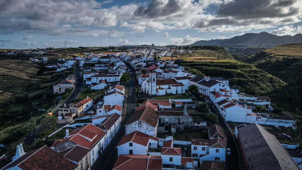
Vila do Porto
The name simply means ‘town of the port’ and even though there isn’t much to do, it’s a good place to base yourself, mainly because of easy access to restaurants, bars and shops. There is basically one main street, perfect for an evening walk starting from the port and Fort de São Brás, all the way to Church of Santo Antão.

Other sights on Santa Maria
Ribeira de Maloás – a short walk leads to the unique formation that occurred due to the contact of the sea with a basaltic lava flow of the Pico Alto Volcanic Complex. it resembles a similar place in Iceland, which is very popular among tourists and can be seen on many photographs online.

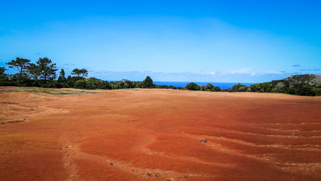
Barreiro da Faneca – A semi-desert with a red landscape and even eucalyptus trees around. If Ribeira de Maloás looks like Iceland, then Barreiro da Faneca definitely awakes the memories from Australia. Breathtaking place!
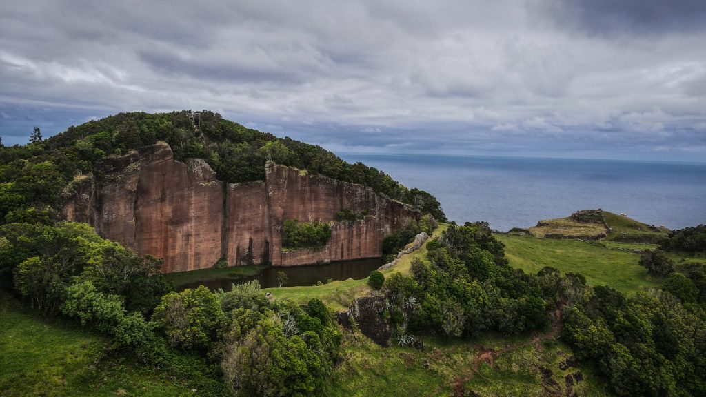
Poço da Pedreira – the shape isn’t really natural as back then it was a quarry where a red stone was extracted and later on used in various constructions around the island. Currently, it’s a nice place for a picnic next to the pond or could be a starting point for the PRC03 hiking trail (loop).

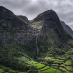
Aveiro Cascade – the most beautiful waterfall on the island, surrounded by stunning vineyard terraces. It is 110 meters high.
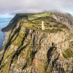
Gonçalo Velho Lighthouse – good viewpoint to Maia and the cliffs.

Praia Formosa – white sand beach in the Azores? Yes, and it’s quite big!
Anjos – Christopher Columbus disembarked in the village on his way back from the discovery of America what is commemorated by the statue. You, on the other hand, can start or finish PR01 SMA – Costa Norte hiking trail here.
Museu de Santa Maria in Santo Espirito – a great place to learn about the history of the island! It’s set in rural house from the 20th century. A knowledgeable guide explaining the exhibition is an additional benefit.
Viewpoints (Miradouro) on Santa Maria
As on every island in the Azores archipelago, there are plenty of viewpoints and usually, they are easily accessible by car. Just look for the sign ‘Miradouro’ which in the Portuguese language means viewpoint. Here is the list of the most popular ones but of course nice views are nearly everywhere and it’s easy to find a stunning ‘no-name’ spot.
- Miradouro de São Lourenço
- Miradouro do Barreiro
- Miradouro das Lagoinhas
- Miradouro da Macela
- Miradouro da Pedra Rija
- Miradouro das Fontinhas
- Farolim da Ponta do Malmerendo
Hiking trails on Santa Maria
PR01 SMA – Costa Norte
The route starts in Bananeiras and soon turns right to descent all the way to Baia do Raposo. A magnificent place with a stream flowing into the ocean and waterfalls in the distance. It’s a kind of a detour to get there, so after a while, you have to climb back to the point where you left the main trail and then continue west until you reach Barreiro da Faneca. It’s a place of the last volcanic activity on the island and the combination of red clay and eucalyptus trees brought up my memories of Australia. From here, it’s really worth taking a detour to Ponta do Pinheiro, about 10-15 minutes each way. After rejoining the main trail, continue straight until another short detour option, this time to Monte Gordo. It’s about 10 minutes ascent, well worth it as well. From there the trail continues towards Ponta dos Frades and then finally ends in Anjos village, right next to the statue of Christopher Columbus.


PRC02 SMA – Pico Alto
The trail begins just next to the parking at Pico Alto. There, you may notice the memorial dedicated to Independent Air Flight 1851 that crashed into the mountain in 1989. Follow the steps going up to the highest point of the island. The view from there isn’t so impressive though, especially with all the antennas around. Return down and go into the forest where the trail stays for most of the remaining distance, but there are also good lookouts to the coast and caldeira.
PRC03 SMA – Entre a Serra e o Mar
Officially, the trails start near the church of Santa Barbara, but you may also begin at Poco da Pedreira, as did I. Cross through the centre of Santa Barbara, head towards Lagos, then in the direction of Norte and finally you will see the Chapel of Nossa Senhora de Lurdes. You definitely should take a detour to a viewpoint over the bay of São Lourenço, which is the highlight of that trail. Return to the main path and continue along the bay until you are back to the starting point.

PR04 SMA – Santo Espirito – Maia
Very pleasant and picturesque trail. It’s a linear one, so I would recommend leaving the car at Maia and hitchhiking to Santo Espirito. Traffic is minimal, but be patient and sooner or later someone will go that way. Start near the church and if you have some extra time, drop by to the Ethnographic Museum of Santa Maria. A very informative place with an awesome guide presenting the history of the island. Next, follow the road passing by the ruin of old windmills and pastures. Continue towards the coast following the stream. Aveiro waterfall is just on the edge of the cliff, but it’s simply too close to be visible well. Follow the trail and after a while look back to admire that 80 meters high miracle of nature. Soon, the descent through vineyards starts to be quite steep so be careful. In Maia, it’s worth taking a detour to the base of Aveiro waterfall, just to see it again from a different (and according to me the best) angle. Lastly, turn back and continue along the asphalt road to the place where you parked your car.


PR05 SMA – Costa Sul
At the moment of writing this text, the trail was officially closed. I did walk it, having in mind that I would simply go back if there was something dangerous. In the end, I arrived at its end as it was perfectly fine all the way. The trail starts in Vila do Porto, next to the Fortress of Sao Brass, then it crosses the stream and continues through dried land to Padreira do Campo. It’s a geological site where marine fossils were found. Shortly after, your will pass by Figueiral Cave, which was created artificially to extract clay for the construction of local houses. Now, ahead of you, there is a steep descent towards Praiha, which is a good place for a break and swimming. The trail passes by the Fortress of Sao Jao Baptisa to finally end at Praia Formosa. Long and wide white sand beach in the Azores? Highly unique but yes, it really exists here so make use of it! Hitchhiking back to Vila do Porto should be relatively easy from here. If it’s not, walk up to the road EN1-2A which is much busier.


PR06 SMA – Areia Branca
This is a great and varied hike connecting Praia Formosa with Baía of São Lourenço. As it’s a linear way and I didn’t feel like doubling the distance, I left the car in Santa Barbara and hitchhiked from there to the turnoff to Praia Formosa. People in Santa Maria are really nice and usually, the first car stops and they try to help you out.
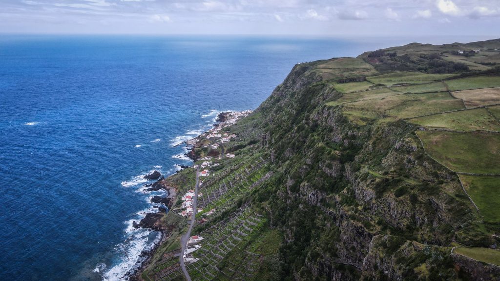
From Praia Formosa, the 6 kilometres ascent towards Pico Alto begins, which can be quite tough in places. After checking out the panorama from there, descent through the farmlands to Santa Barbara. Go through the town and then descent even more on a very steep path leading all the way to Baía of São Lourenço. The views here with all that vineyards in terraces looking like a chessboard are truly amazing. The trail ends next to the beach. After some chilling and drone flight, I hiked back to Santa Barbara (which unfortunately was quite a tiring way up) to pick up my car.


Great Route of Santa Maria
The mother of all the hiking trails on Santa Maria. The distance of 78 km is suggested to be covered in four stages, but honestly, I believe it could be done in three if you don’t mind walking more than 20 km a day. It starts in Vila do Porto and then goes basically around the whole island: Vila do Porto – Cordal – Norte – Bananeiras – Vila do Porto. Certainly, a great adventure which is on my list if I ever come back to this region of the world 🙂