
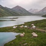
Ala Archa National Park is one of Kyrgyzstan’s most popular natural reserves, located about 40 kilometres south of Bishkek in the Tian Shan Mountains. The park is renowned for its dramatic alpine scenery, featuring snow-capped peaks, glaciers, and high ridges. It is a favourite destination of locals for hiking, climbing, and picnicking, offering trails that range from short walks along the river to challenging treks up to glaciers and mountain huts.
The park is home to diverse wildlife, including ibex, marmots, and a variety of bird species, as well as rich alpine flora. Its proximity to the capital makes it an easily accessible escape into nature.
How to get there?
Getting to Ala Archa National Park is quite straightforward since it lies only about 40 kilometres south of Bishkek. First, you will need to get to the official entrance, where you can buy a ticket and change to official minibuses, which can take you further into the park. Most visitors start from the capital, where you have a few options:
By Car or Taxi
The easiest way is to take a taxi or arrange a private transfer. The drive takes around 40–50 minutes, following the main road that leads straight to the park’s entrance. Expect to pay about 800 – 1000 SOM for a Yandex taxi from the Bishkek city centre.
By Bus
Bus #1 goes from Bishkek city all the way to the park entrance. You can see its route HERE.
By Minibus (marshrutka)
Budget travellers can catch a marshrutka from Bishkek heading in the direction of Kashka Suu. You’ll need to get off at the park turnoff and continue either on foot or arrange local transport for the last stretch to the gate. Not very convenient.
Guided Tours
Many local agencies in Bishkek offer half-day or full-day trips, which include transport and a guide, making it a convenient option for those who prefer not to plan logistics themselves. Your time in the park will be limited, though, and I honestly do not know what the point of half-day trips is. I guess just taking a photo from the viewpoint and going back to Bishkek. This park definitely deserves more of your time and energy!
The best time to visit
Spring (April–May): The park comes alive with blooming wildflowers, and the weather is mild, making it a pleasant season for day hikes. Some higher trails may still have snow.
Summer (June–August): This is the most popular season. Trails are fully accessible, and the weather is warm but cooler than in Bishkek, offering great conditions for longer treks and climbing.
Autumn (September–October): Crisp air, fewer crowds, and colourful landscapes make this one of the most beautiful times for photography and hiking.
Winter (November–March): Snow covers the park, creating opportunities for skiing and ice climbing, but many trails become inaccessible without special gear.
How much does the entrance cost?
Visitors to Ala Archa National Park are required to pay an entrance fee of 200 KGS, which is collected at the main gate. Payment by card is possible. From the gate, an electric shuttle or minibus operates to take guests further inside the park, covering the roughly 12-kilometre distance. The ride is included in the entrance ticket.
Where to stay in Ala Archa National Park?
Along the main asphalt road, you can find Alp Lager Hotel as well as guesthouses and cabins just outside or near the park gate.
Camping is possible anywhere in the park and is perfectly legal. On the Mapy.com app, you can see several locations indicated as campsites. There are no facilities, but usually it’s just a flat terrain suitable for pitching your tent.
Alternatively, you can hike up to Ratsek Hut, though it is a good idea to arrange a spot in advance by contacting Ak-Sai Travel at 0312-909-356 or adventure@ak-sai.com. They also provide meals in the hut.
Where to stay in Bishkek?
During my several-day stay in Bishkek, I stayed in four different hotels:
Inter Hotel Bishkek: Probably the best price-to-quality ratio. Good locations, modern room.
Hotel Touristan: The room was huge and clean. The receptionist was super helpful, and I even received a fridge magnet as a gift. The only negative was that the AC didn’t work too well.
Malinka: More like a guesthouse rather than a hotel. The room was well equipped with a kettle, tea, sugar, and toiletries. Very friendly owner who let me leave a part of my luggage for several days as I was hiking in Ala Archa National Park.
Hotel T: Very simple, however, a comfortable room.
Terrasse Hotel & Bar: A luxurious establishment offering stunning panoramic views of the mountains and the city. I had to get a really good deal on booking.com, as in the next days the rooms became 4 times more expensive
FAQ
Do you need a guide to Ala Archa?
No, a guide is not required to Ala Archa; you can go there on your own. Getting there and navigating the area is relatively easy. However, a guide can be useful if you don’t have any mountain experience or if you prefer not to worry about logistics, weather, or orientation. For those who enjoy exploring at their own pace and prepare in advance, a self-guided visit to Ala Archa is perfectly sufficient.
Is Ala Archa suitable for a day trip?
Yes, Ala Archa is very suitable for a day trip. The park is relatively close to Bishkek (about 40 km), so you can easily get there in the morning and then spend the day walking, picnicking, and shorter treks in the valley. Many people choose day trips.
Are the trails in Ala Archa well-marked?
The trails in Ala Archa are largely well-marked in the lower part of the park, closer to the entrance. On the main trails, such as those towards Ak-Sai Falls or along the river valley, you’ll find marked paths and maps at the entrance, and the trail itself is clearly marked enough for most people to find it easily. As you go deeper into the park, the markings become less frequent, so it’s a good idea to have a map or a route app handy.
Hiking trails in Ala Archa National Park
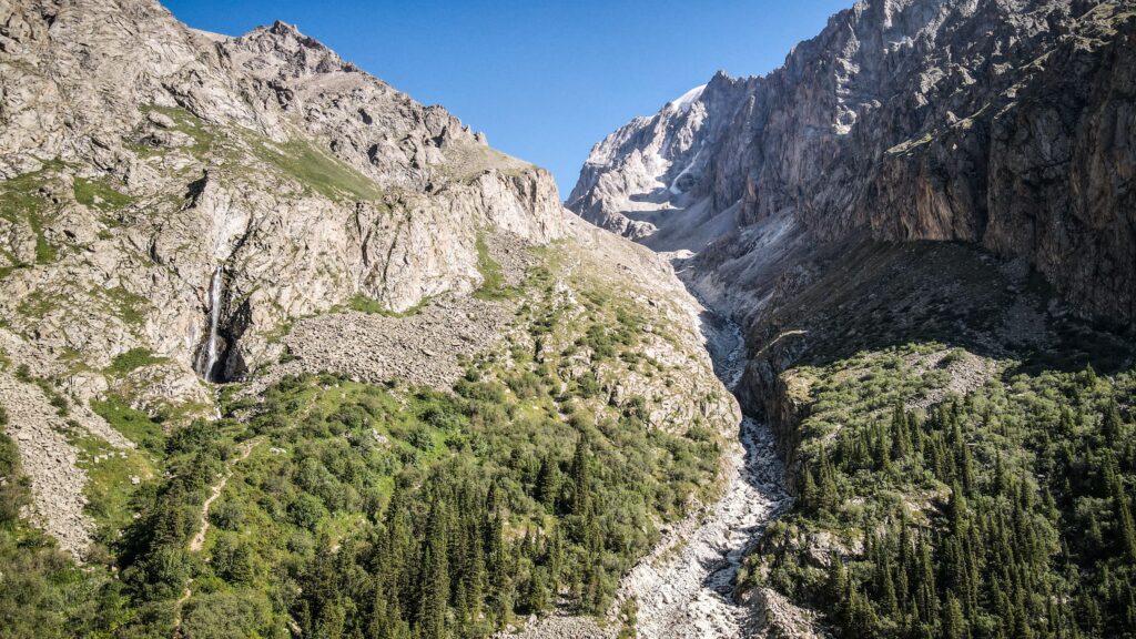
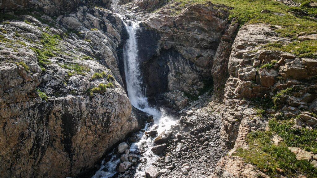
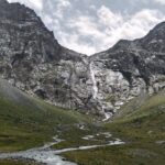
Ak Say Waterfall
Distance: 8 km / Time: 5 hours (there and back) / Elevation gain: 670 m
The hike begins from Alp Lager, the base area where most trails in Ala Archa start. At first, the trail follows asphalt and then dirt road, with sweeping views of the valley already visible behind you. The route is well-trodden and easy to follow, but it gains elevation quickly, so you’ll feel the climb right away.
After about an hour, the terrain becomes steeper and more exposed. There are few trees along this section, meaning the sun beats down strongly. The higher you go, the more dramatic the scenery becomes, with sharp ridgelines on either side.
Eventually, the sound of the Ak-Say Waterfall grows louder until you round a corner and see it plunging from the cliffs above. The spot is popular, especially on weekends, so expect to meet fellow hikers pausing for photos and snacks. Despite the crowds, it’s a stunning natural highlight and a rewarding destination for a half-day outing.
From here, many trekkers choose to turn back, but the trail continues upward toward Ratsek Hut and the Uchitel Glacier for those with more time and energy. Read more about it further down.
Komsomolets Peak
Distance: 14,2 km / Time: 10-11 hours (there and back) / Elevation gain: 2,009 m
The trail first follows the same route toward Ak Say Waterfall before branching off onto steeper ground. The climb is long and demanding, with rocky ridges and sections of scree requiring steady footing. As you gain elevation, the panorama widens to reveal glaciers and neighbouring summits of the Kyrgyz Ala-Too range. It’s a strenuous outing best suited for strong hikers, but the sense of accomplishment at the top is unforgettable.
Intourists occasionally organises group hikes there, in case you don’t want to climb it solo.
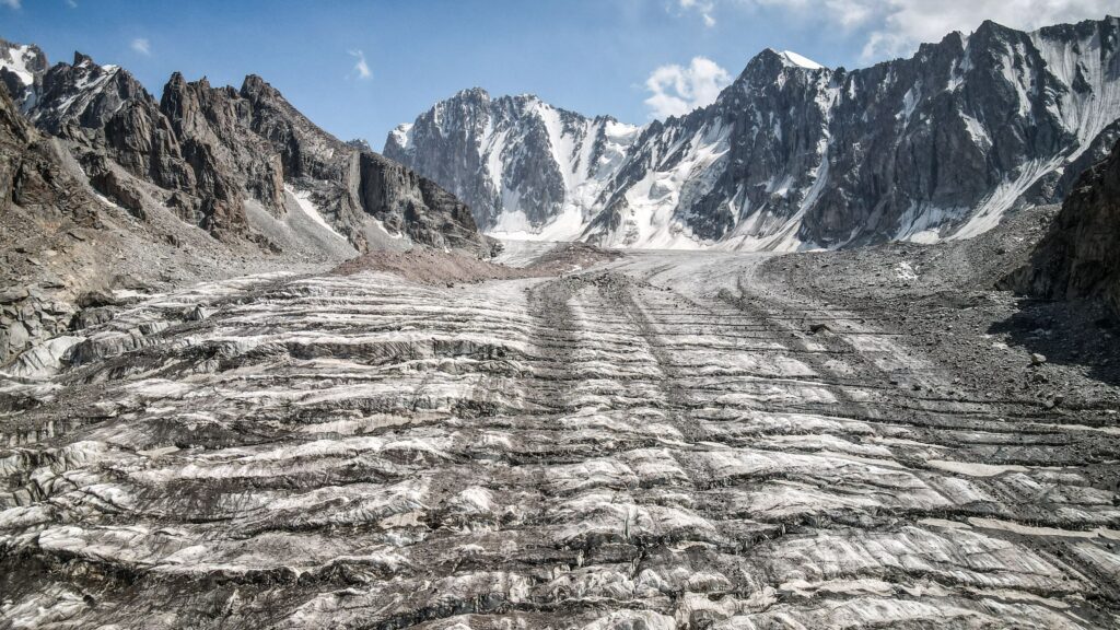
Hut at the Golubin Glacier (Khizhina U Lednika Golubina)
Distance: 21,5 km / Time: around 8-9 hours (there and back) / Elevation gain: 1,069 m
This hike follows a scenic route along the left side of the river before climbing gradually toward the moraine of the Golubin Glacier. The destination is an abandoned and collapsed hut tucked beneath towering peaks. The trail is moderately challenging, with sections across rocky terrain, but the scenery is breathtaking throughout. Glacial streams, alpine meadows, and rugged cliffs make this one of the most picturesque valleys in Ala Archa.
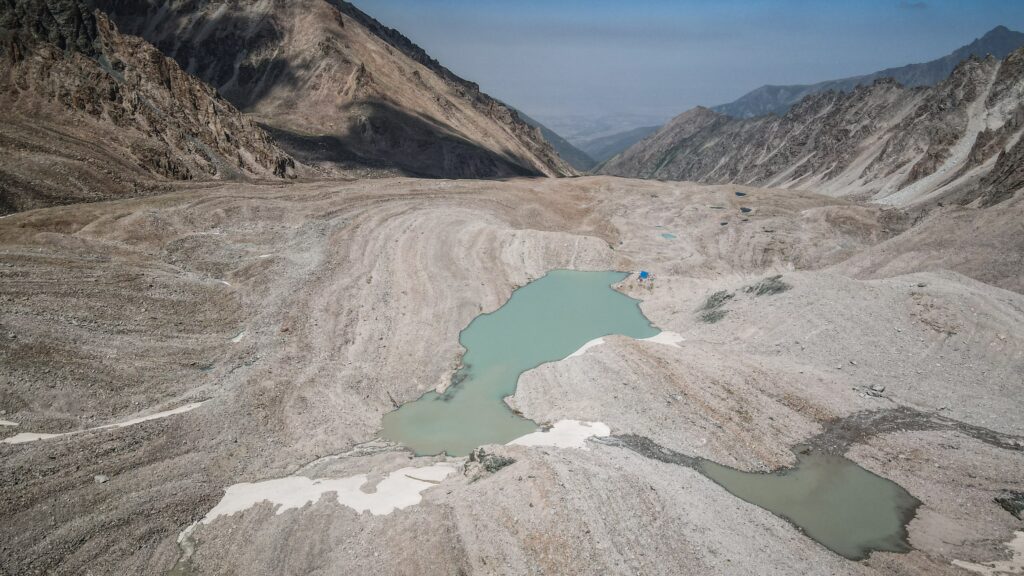
Adygene Lake
Distance: 18 km / Time: around 9-10 hours (there and back)
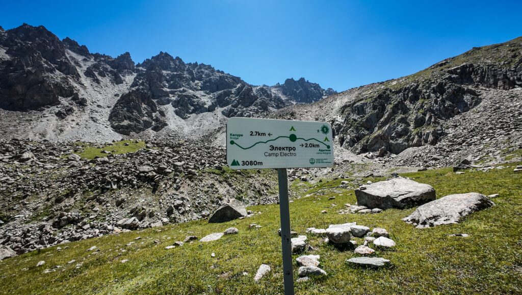
The hike to Adygene Lake starts just before the final stop of the minibus, so it’s worth asking the driver to drop you at the right spot. When I arrived, there was some construction nearby, so I had to detour a little to find the trail. I was the only one stepping off the bus, and for most of the day, I met only a handful of other hikers, which made the journey feel wonderfully remote.
The trail followed the river for a while until it was time to cross. River crossings usually make me nervous, but this one turned out to be fairly straightforward. Higher up the path, I finally spotted some fellow hikers, a lively group of teenagers who showed me the way down a cliff and across another stream.
A bit later, I reached Camp Elektro, where I stopped for a snack and a quick chat with another hiker heading up to Elektro Summit. From there, the route to the lake grew tougher. The final section led across a vast field of boulders, requiring careful steps to avoid twisting an ankle. With no trail markings, I relied on my map app to keep me on course.
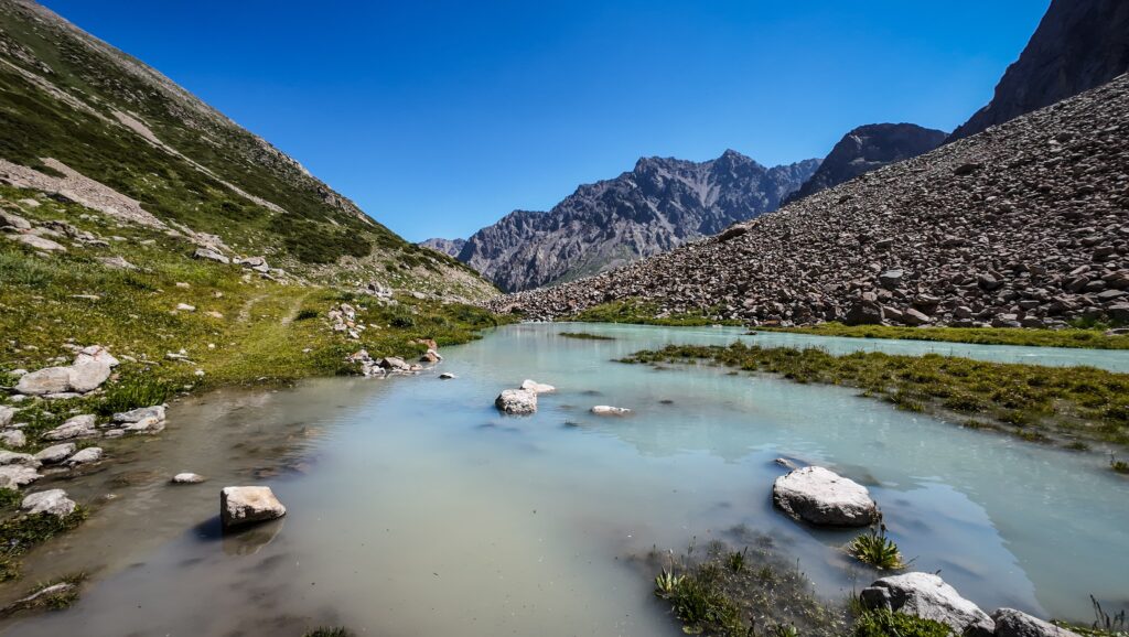
Eventually, the turquoise waters of Adygene Lake came into view, along with a small hut nearby. Getting there wasn’t simple, and the last challenge was balancing across a rough wooden plank laid over a fast-moving stream. Once I made it, I sat down for lunch, flew my drone to capture the stunning scenery, and soaked in the quiet beauty of the place.
The hike back felt livelier. I crossed paths with more hikers, especially in the valley below Camp Elektro. On the descent, I chose a track on the right-hand side, which led me down to the main road. By the time I reached the central area of the park, the solitude of the lake was replaced by crowds, snack stands, and the comfort of a cold cola. From there, I wandered off to look for a place to camp for the night.
Agitator Peak
Distance: 16,2 km / Time: around 10-12 hours (there and back) / Elevation gain: 2,150 m
For those looking for a rewarding climb, the hike to Pik Agitatorov (4,244 m) offers the perfect balance. The route begins from the same spot as the trail to Adygene Lake, leading up through rocky slopes and grassy ridges. The ascent is steep and requires good stamina. From the summit, the panorama over the surrounding peaks is magnificent.
Intourists occasionally organises group hikes there, in case you don’t want to climb it solo.
The Abandoned Ski Resort “Upper Ala-Archa”
Distance: 31 km / Time: 10-12 hours (there and back) / Elevation gain: 1,244 m
I set out along the trail on the right side of the river, following advice I’d read online. It turned out to be the right choice as ater on, I noticed how powerful the water on the left side was, and crossing there would have been nearly impossible.
Even so, the right path wasn’t always straightforward. Sections were overgrown and lacked clear markings, so I relied on intuition and my offline map to stay on track. As the climb began, the trail gradually opened up to a flatter stretch where a small lake appeared. I paused for a rest and saw a group coming from the opposite direction, so they must have camped somewhere nearby.
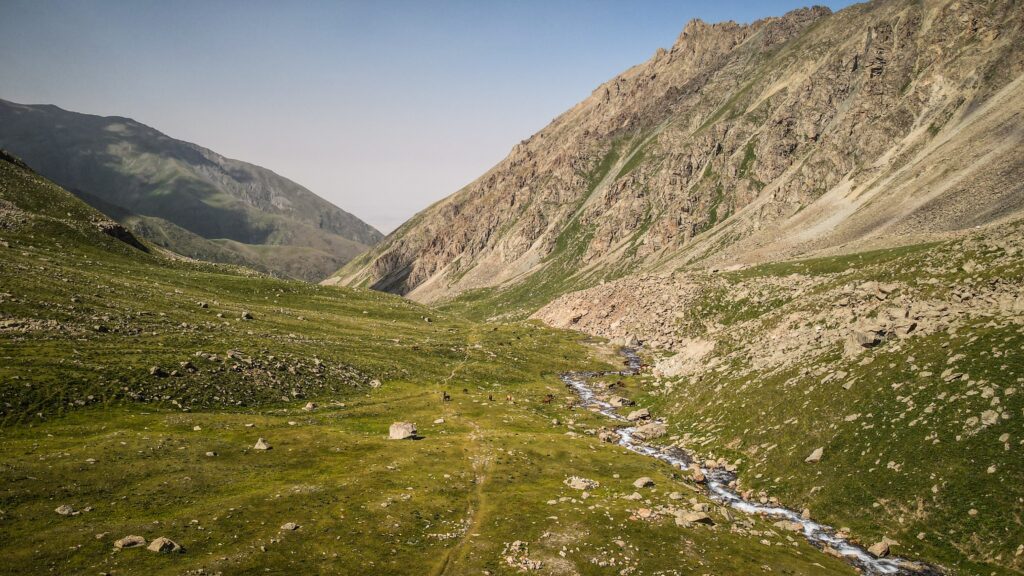
Further along, I passed the remains of an abandoned weather station. The landscape here was breathtaking: lush meadows, free-roaming horses, streams winding through the grass, and wide green valleys. Occasionally, I had to hop across boulders to keep my boots dry.
As I gained more altitude, the greenery gave way to a harsher terrain of bare rocks and scattered stones. Eventually, I reached a stream with just a few meters left to climb before arriving at the ruins of the old ski station. I sent my drone up to capture the wide panorama and then climbed a bit higher on foot for a better view of the glacier beyond. If the stream feels too tricky to cross, stick to the right bank and look for an easier crossing point further down.
The way back was less demanding since it was downhill, but fatigue and the afternoon heat started to set in. I stopped to search for an abandoned crawler tractor I’d heard about and launched the drone again near a striking waterfall.
Retracing my steps past the weather station, I met a group of hikers heading up. They were clearly planning to camp in the area, which actually seemed like a perfect spot. Before moving on, I splashed my face in the icy stream to cool down, then carried on until I reached my camping place near the bridge. Camping there saved me a bit of distance, but for anyone starting from Alp Lager, this hike makes for a long and demanding full-day adventure.
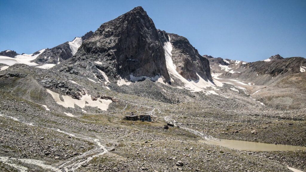
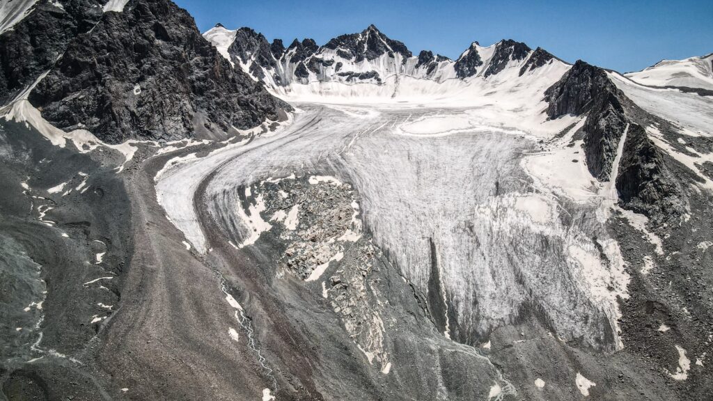
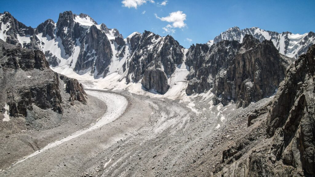
Ratsek Hut and Uchitel Glacier
Distance: 14,5 km / Time: 8-10 hours (there and back) / Elevation gain: 1,460 m
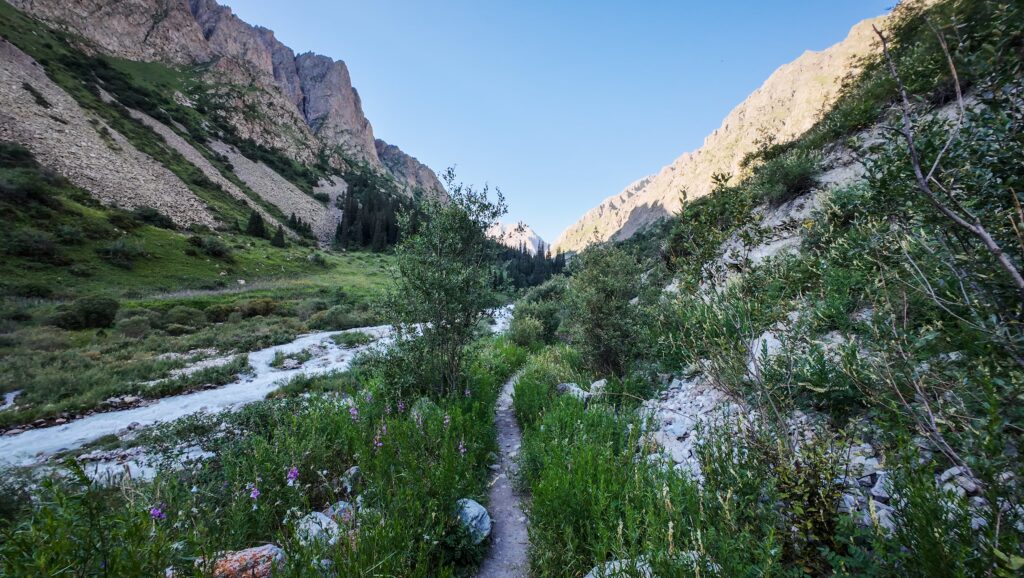
Because of the ongoing cable car construction, the route to Ratsek Hut begins along a wide dirt road that climbs steadily upward toward a rock formation known as the “Broken Heart.” This landmark is a cliff face split down the middle, resembling a heart cracked in two, and it’s a well-known viewpoint in Ala Archa National Park. The climb here is fairly steep and fully exposed, so carrying enough water and applying sunblock is essential.
I paused for a longer break at the Ak-Say Waterfall, a spectacular cascade tumbling into the gorge below. It was beautiful but not exactly tranquil since it was the weekend, and plenty of other hikers were making their way up the same trail.
From there, the path steepens for the final push to Ratsek Hut. Reaching the camp felt rewarding, and I quickly set up my tent in an available spot before heading inside the hut for food and refreshments. The solyanka soup was delicious and hearty, just what I needed after the climb, and I couldn’t resist treating myself to a cold cola. I also arranged dinner for later. The campsite was buzzing with activity: tents scattered across the meadows, climbers preparing their gear, and others settling into bunk beds inside the hut. This spot is a hub for both trekkers and rock climbers, giving it a lively, communal atmosphere.
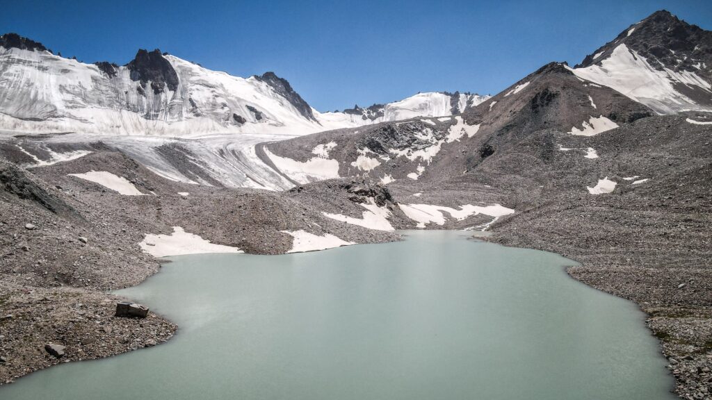
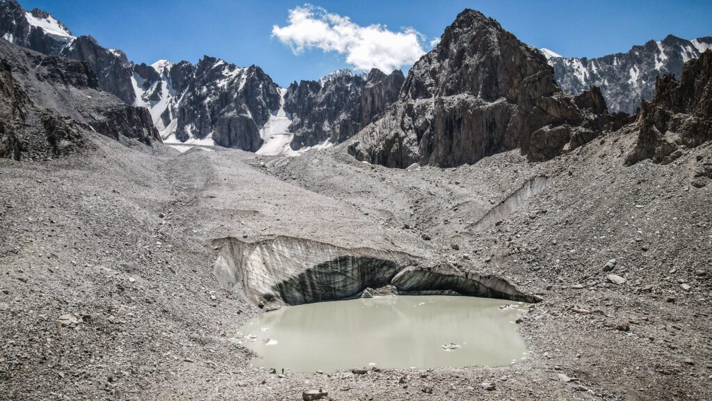
Later in the afternoon, I continued further up the trail toward the Uchitel Glacier and its small glacial lake. The last stretch was tricky, requiring careful navigation across a boulder field. When I finally arrived, I was greeted by a dramatic scene: the lake, backed by an immense wall of ice that occasionally shed stones and chunks into the water with a thunderous crash.
Back at the hut, dinner was served – a simple stew with noodles. Not that impressive, but filling enough after a long day on the trail.
Hikes from Ratsek Hut
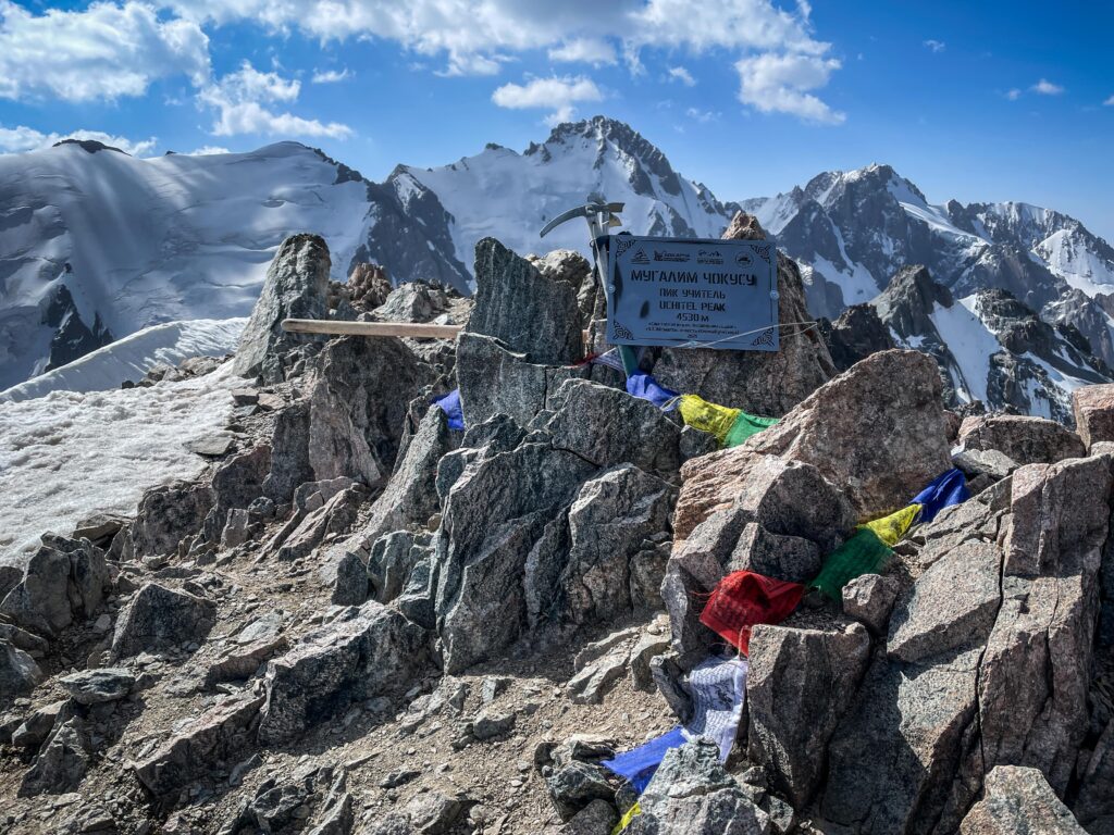
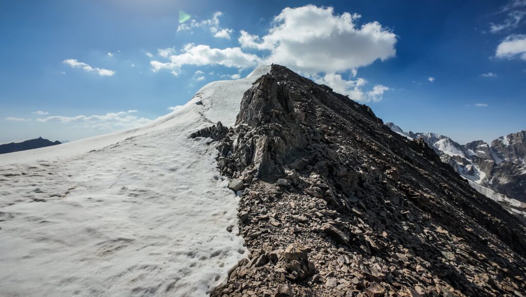
Uchitel Peak
Distance: 5.6 km / Time: 5-6 hours (there and back) / Elevation gain: 1,155 m
I woke up before dawn, setting out on the trail to Uchitel Summit just after 6 AM. The area was still quiet, and for the first part of the climb, I didn’t see a single other hiker. The path was long and relentlessly steep, and in places it almost disappeared. Luckily, I was able to see the trail and my position on Mapy.com. I slipped once, sending loose stones tumbling down the incline, and for a moment, my heart was in my throat.
Pushing upward, I eventually caught sight of tiny figures silhouetted on the summit far above. Just knowing others had already made it there gave me a boost of motivation. The final stretch was a demanding mix of snow on the left and jagged rocks on the right, but step by step, I closed the distance.
The panorama stretched endlessly across the Ala Archa range, peaks and glaciers glowing in the morning light. A couple who had camped overnight were packing up their tent, and two other hikers lingered a while before starting their descent. Soon, I was alone on the summit. Just me, the mountains, and the silence. It was an unforgettable moment.
The way down, though steep, felt easier; somehow, the route was clearer when looking at it from above. By then, more hikers had begun their ascent, filling the trail that had been empty just hours earlier.
Korona Hut
Distance: 6 km / Time: 5-6 hours (there and back)
The route to Korona Hut climbs steadily toward the foot of the massive Korona Peak, named for its crown-shaped summit ridge. The trail crosses a mix of rocky moraines and glacial terrain, often requiring careful footing on loose stones. As you get closer, the jagged spires of Korona tower above, and the hut itself comes into view, perched on a rocky outcrop with front-row views of the glacier. It’s a rugged but spectacular spot, often used by climbers preparing for ascents of nearby peaks.
Nauka Hut
Distance: 5.9 km / Time: 4-5 hours (there and back)
The hike to Nauka Hut branches in another direction, heading toward the Ak-Sai Glacier. This path also demands attention, as it crosses boulder fields and uneven ground, but it is rewarded with stark high-mountain views. The hut, a modest structure built for climbers and researchers, sits in a breathtaking setting directly beneath the icefall.
2 Comments
Który z tych krajów wybralibyście na pierwszą podróż w tę część świata i dlaczego akurat ten? Kazachstan, Kirgistan, Uzbekistan, Tadżykistan, Turkmenistan. Który uważacie, że jest najtańszy na miejscu (noclegi, jedzenie, przemieszczanie się)? Który zachwycił Was najbardziej i czym?
Byłem jedynie w Kirgistanie i bardzo krótko w Kazachstanie. Ten pierwszy z pewnością tańszy, natura przepiękna, głównie góry.