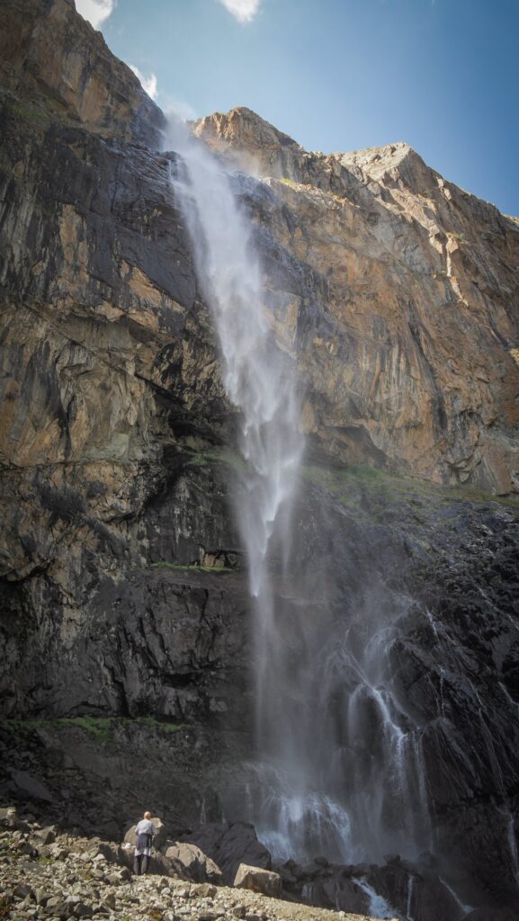
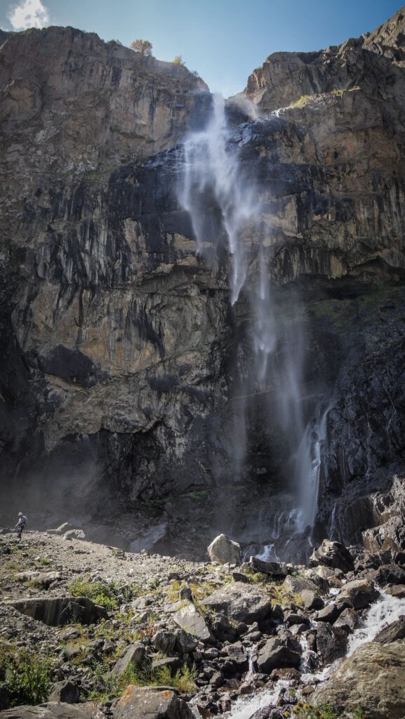
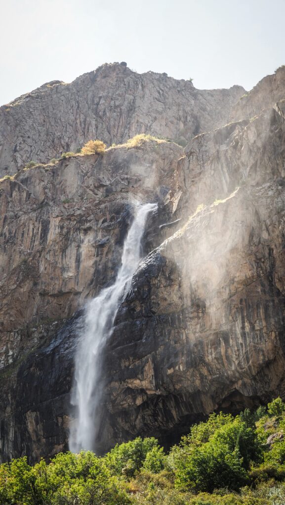
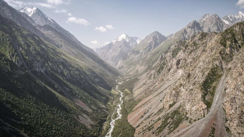
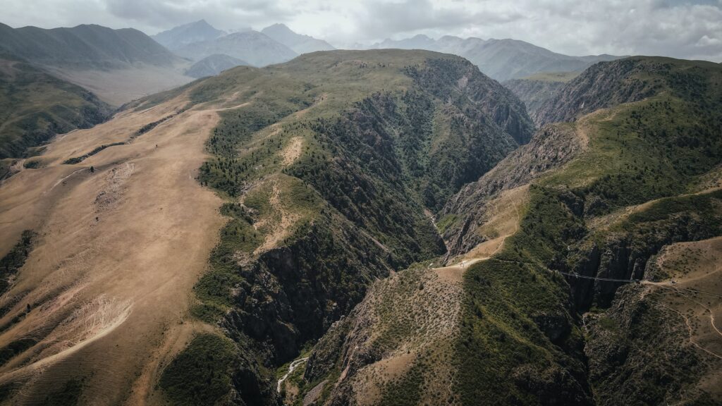
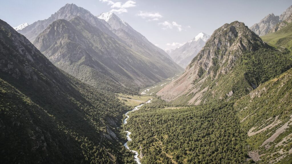
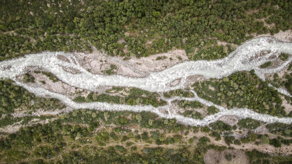
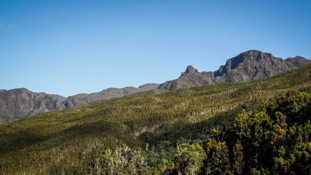
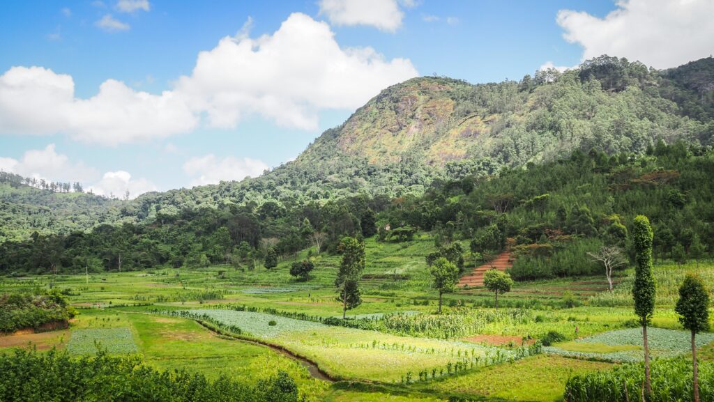
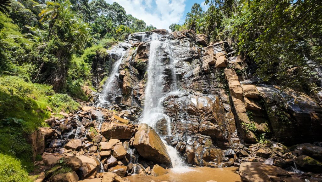
Belogorka Waterfall is one of the most striking natural sights near Bishkek. It lies deep in the Sokuluk Gorge of the Chuy region, about 70–80 kilometres from the capital, at an elevation of over two thousand meters. The waterfall itself drops from a height of around 60 meters, sending up a fine spray that cools the air even on hot summer days. The cascade is fed by mountain streams, and its surroundings are rugged and dramatic, with sharp cliffs, smaller falls, and a prominent peak known locally as the Black Spire.
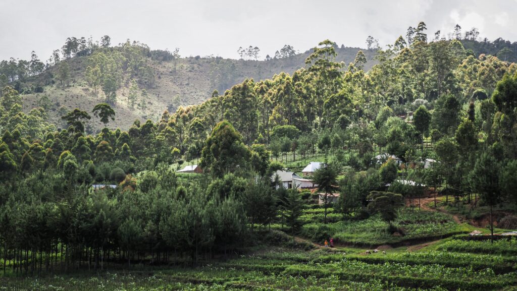
The gorge is especially beautiful in late spring and summer, when the slopes are covered with wildflowers, berry bushes, and dense greenery. To reach the site, visitors usually drive as far as the rough road allows, then continue on foot for about two kilometres. The walk is not technically difficult and can be done in an hour, but the rocky ground and mountain weather call for sturdy shoes and warm layers.
Because of its relative closeness to Bishkek, Belogorka has become a popular destination for hikers and day-trippers who want a glimpse of Kyrgyzstan’s alpine scenery without venturing too far into the high mountains.
How to get to Belogorka?
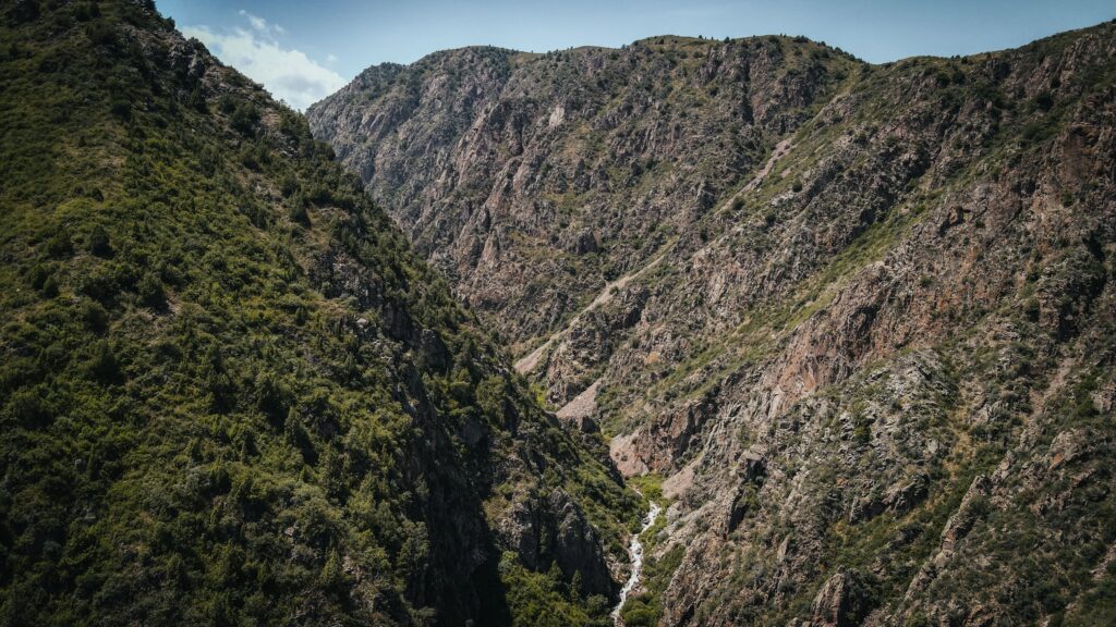
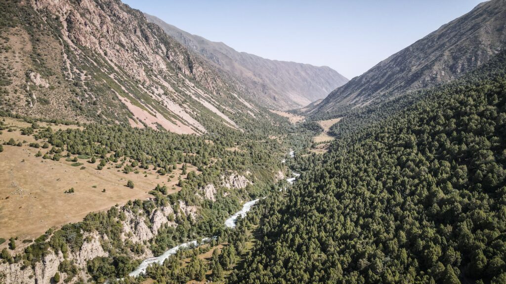
The journey to Belogorka Waterfall typically begins in Bishkek, where travellers head west out of the city by road. After passing through several villages, the route turns into the Sokuluk Gorge, where the scenery quickly shifts from open plains to steep mountain slopes. The paved road eventually gives way to a rougher track, which can be handled by most cars in dry weather but is easier with a high-clearance vehicle. Travellers often leave their car or hire transport up to a small bridge or the last drivable section of road. From there, the waterfall can be reached on foot along a roughly three-kilometre trail. The walk takes about one to two hours at a relaxed pace, leading through meadows, streams, and rocky paths before the sound of falling water announces the destination.
For those without their own vehicle, it’s possible to take a minibus (marshrutka) from Bishkek toward Sokuluk village and then hire a local taxi to bring you deeper into the gorge. Another option is to negotiate directly with a taxi driver in Bishkek for a round trip, which is more expensive but saves time and avoids transfers. Marshrutkas leave from central minibus hubs (Osh Bazaar is a commonly named starting point).
Another comfortable way to reach the waterfall is with a tour. Local companies such as Kettik or Intourist frequently organise day trips there and to other locations around Bishkek. Check their profiles on Instagram.
The best time to visit
The best time to visit Belogorka Waterfall is during the warmer months, roughly late spring through early autumn. From May to September, the gorge is at its most inviting: the river has a strong flow from snowmelt and mountain springs, the meadows are covered with wildflowers, and the weather is generally comfortable for hiking. Early summer is especially beautiful, with fresh greenery and cooler air in the valley. By late summer and early autumn, the paths are drier and easier to walk, and the surrounding trees start to show autumn colours.
In contrast, winter and early spring are not ideal. Snow and ice can make the road into the gorge difficult or impossible to drive, and the trail itself can be slippery and dangerous. The waterfall doesn’t disappear in winter, but it can freeze partly or fully, making it harder to reach and less accessible for most visitors.
Where to stay in Bishkek?
During my several-day stay in Bishkek, I stayed in five different hotels:
Inter Hotel Bishkek: Probably the best price-to-quality ratio. Good locations, modern room.
Hotel Touristan: The room was huge and clean. The receptionist was super helpful, and I even received a fridge magnet as a gift. The only negative was that the AC didn’t work too well.
Malinka: More like a guesthouse rather than a hotel. The room was well equipped with a kettle, tea, sugar, and toiletries. Very friendly owner who let me leave a part of my luggage for several days as I was hiking in Ala Archa National Park.
Hotel T: Very simple, however, a comfortable room.
Terrasse Hotel & Bar: A luxurious establishment offering stunning panoramic views of the mountains and the city. I had to get a really good deal on booking.com, as in the next days the rooms became 4 times more expensive.
Is it worth it?
In my opinion, coming to Belogorka Waterfall was totally worth it. It’s a beautiful, calm place with splendid mountains and nature wherever you look, and if you are lucky with timing, you may have the place just for yourself. During my visit, it was windy, so the mist from the waterfall cooled me down effectively.
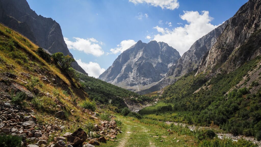
If you want to extend the exploration of the area, you can follow the dirt road that climbs from the parking area up the hill. You will reach another waterfall there, and you can continue even further into the valley as the trail continues for several kilometres to Sukuluk I Pass. Make sure you have an offline map such as Mapy.CZ to track your location.
The way to another waterfall:
The trail towards Sukuluk Pass I
Alternatively, you may also continue further into Sokuluk Gorge; however, the trail is overgrown and not very visible. Just follow the stream. Eventually, the trail connects with Ala Archa National Park, but to get there, you will need to bring your tent, food, and most importantly: navigational skills and mountain hiking experience.
Bishkek is the capital and largest city of Kyrgyzstan, situated in the north of the country near the border with Kazakhstan. It lies in the fertile Chüy Valley at the foot of the Tian Shan mountains, giving it both strategic and agricultural importance. It’s the political, economic, and cultural heart of Kyrgyzstan, but its past has seen many transformations.
Short history of Bishkek
The area around Bishkek has been inhabited for centuries thanks to its rich pastures and trade routes. During the Silk Road era, settlements thrived in the Chüy Valley, serving as rest stops for merchants and caravans. However, Bishkek itself began as a modest fortress in the 19th century.
In 1825, the Kokand Khanate built a fort on the site to control local trade and nomadic tribes. The Russians captured it in 1862, demolished the fort, and established a garrison town called Pishpek. This marked the beginning of a new phase, as Slavic settlers arrived, and the settlement gradually grew into an administrative hub.
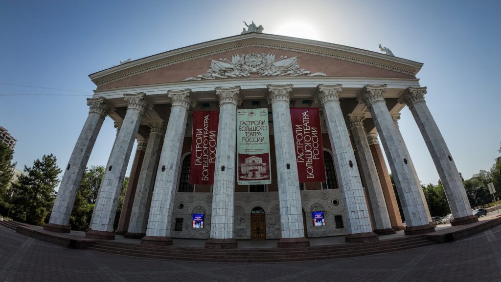
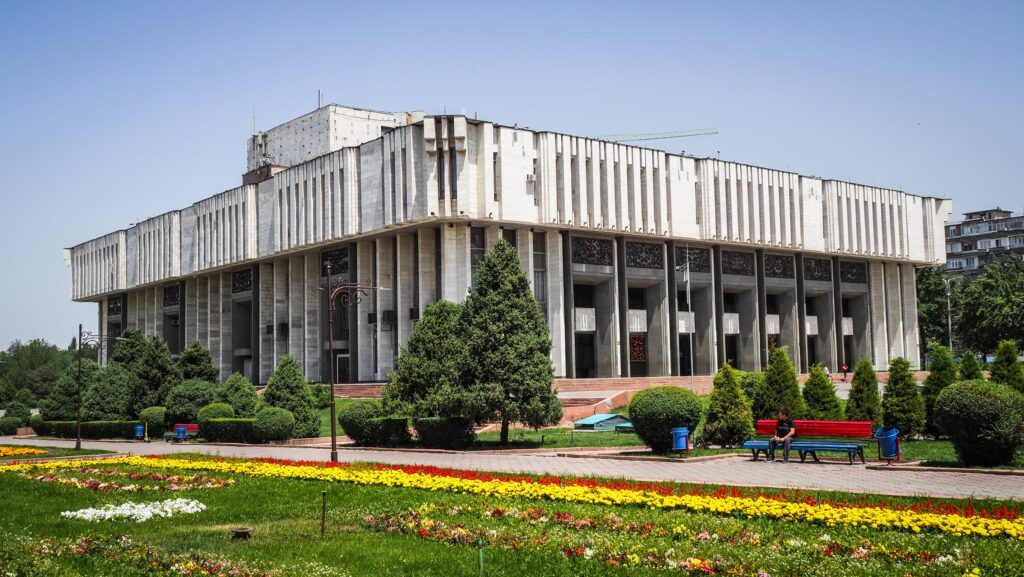
Opera House
When the Bolsheviks took over Central Asia, Pishpek became part of the newly created Kyrgyz Autonomous Soviet Socialist Republic in 1926. At that time, it was renamed Frunze, in honour of Mikhail Frunze, a Red Army leader born in the city. Under Soviet rule, it transformed from a dusty frontier town into a planned city with wide boulevards, Soviet-style architecture, factories, and universities.
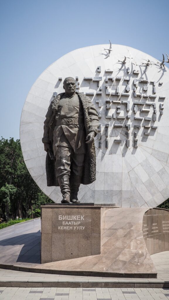
With Kyrgyzstan’s independence in 1991, the city adopted the name Bishkek, which is linked to a traditional wooden churn used to make kumis (fermented mare’s milk), a staple of Kyrgyz nomadic culture. Since then, it has developed into a vibrant capital balancing Soviet heritage, Central Asian traditions, and modern influences.
How to get to Bishkek?
By Air
Manas International Airport (FRU) is Bishkek’s main gateway, located about 30 km northwest of the city. It has direct flights from major regional hubs like Istanbul, Moscow, Dubai, Tashkent, and Almaty.
From the airport, travellers usually take a taxi, ride-hailing app, or shared minibus (marshrutka) into the city centre.
By Road
Bishkek is connected by long-distance buses and shared minibuses (marshrutkas) to nearby cities in Kazakhstan and within Kyrgyzstan.
The Almaty–Bishkek route is especially popular, with frequent services that cross the border at Korday.
Roads from Osh, Karakol, and Issyk-Kul also converge in Bishkek, making it a transport hub inside Kyrgyzstan.
By Car
Driving into Bishkek is common for regional travellers. Border crossings with Kazakhstan are well-used, but travellers should be prepared for possible delays.
Renting a car is an option inside Kyrgyzstan, especially for those planning to explore the mountains and countryside beyond the capital. I can wholeheartedly recommend the company “Rent a Car 4×4 in Kyrgyzstan Bishkek”, which can be contacted on WhatsApp: +996508811770. Super friendly and unproblematic experience.
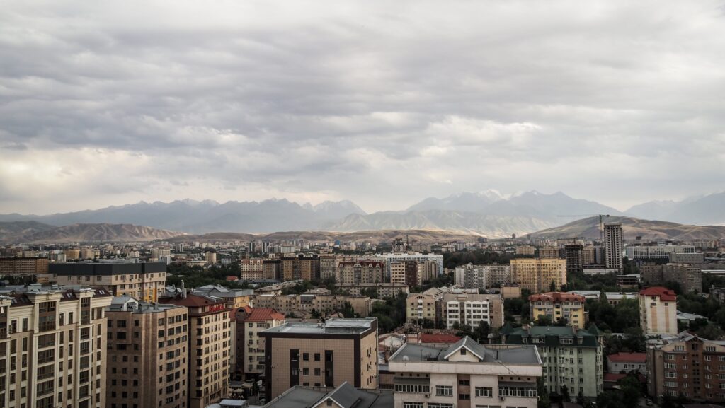
Soviet architecture of BishkekPanorama of Bishkek and the mountains
The best time to visit
Spring (April–June): This is one of the most pleasant periods. The weather warms up, the mountains around the city are still capped with snow, and the valleys are covered in wildflowers. It’s a great time for city walks and light hiking.
Summer (July–August): Summers are hot, often above 30°C, but the city’s tree-lined streets offer shade. This is the season when many people use Bishkek as a base to head into the cooler mountains, lakes, and alpine pastures nearby.
Autumn (September–October): Another ideal window to visit. The heat has eased, the skies are usually clear, and harvest season fills local markets with fresh produce. The golden foliage also makes the city and the surrounding valleys especially scenic.
Winter (November–March): Bishkek experiences cold, snowy winters. While the city itself may feel grey, this is the time for skiing and winter sports in resorts like Chunkurchak or Karakol, which are accessible from Bishkek.
Where to stay in Bishkek?
During my several-day stay in Bishkek, I stayed in five different hotels:
Inter Hotel Bishkek: Probably the best price-to-quality ratio. Good locations, modern room.
Hotel Touristan: The room was huge and clean. The receptionist was super helpful, and I even received a fridge magnet as a gift. The only negative was that the AC didn’t work too well.
Malinka: More like a guesthouse rather than a hotel. The room was well equipped with a kettle, tea, sugar, and toiletries. Very friendly owner who let me leave a part of my luggage for several days as I was hiking in Ala Archa National Park.
Hotel T: Very simple, however, a comfortable room.
Terrasse Hotel & Bar: A luxurious establishment offering stunning panoramic views of the mountains and the city. I had to get a really good deal on booking.com as in the next days the rooms became 4 times more expensive.
Q&A
Is Bishkek worth visiting?
Yes. Bishkek is a relaxed, green city with wide boulevards, Soviet-era architecture, lively cafés, and easy access to mountains. It works well as both a short city break and a base for nature trips.
How many days should I spend in Bishkek?
Two to three days is ideal for the city itself. Add extra days if you plan day trips to nearby places like Ala Archa National Park or the Burana Tower.
Is Bishkek safe for tourists?
Generally yes. Violent crime is rare, but like in any city, watch out for pickpocketing in crowded areas and markets. Basic awareness is enough.
Do people speak English in Bishkek?
English is spoken in hotels, hostels, and by younger people, but Russian is much more widely used. Knowing a few Russian phrases helps a lot.
Is Bishkek expensive?
No. Bishkek is affordable compared to many capitals. Food, transport, and accommodation are reasonably priced, especially for budget travelers.
How do I get around the city?
Taxis and ride-hailing apps (Yandex) are cheap and convenient. Marshrutkas (shared minibuses) are very affordable but can be confusing for first-time visitors.
What food should I try in Bishkek?
Try plov, lagman, manty, samsa, and local bread. Bishkek also has good cafés and international food thanks to its student and expat scene.
Can I do day trips from Bishkek?
Absolutely. Ala Archa National Park is the most popular day trip, and places like the Burana Toweror Issyk-Ata Gorge are also easy to reach.
Do I need a visa to visit Kyrgyzstan?
Many nationalities can enter visa-free for a certain period. Always check the rules for your passport before traveling.
What to see in Bishkek?
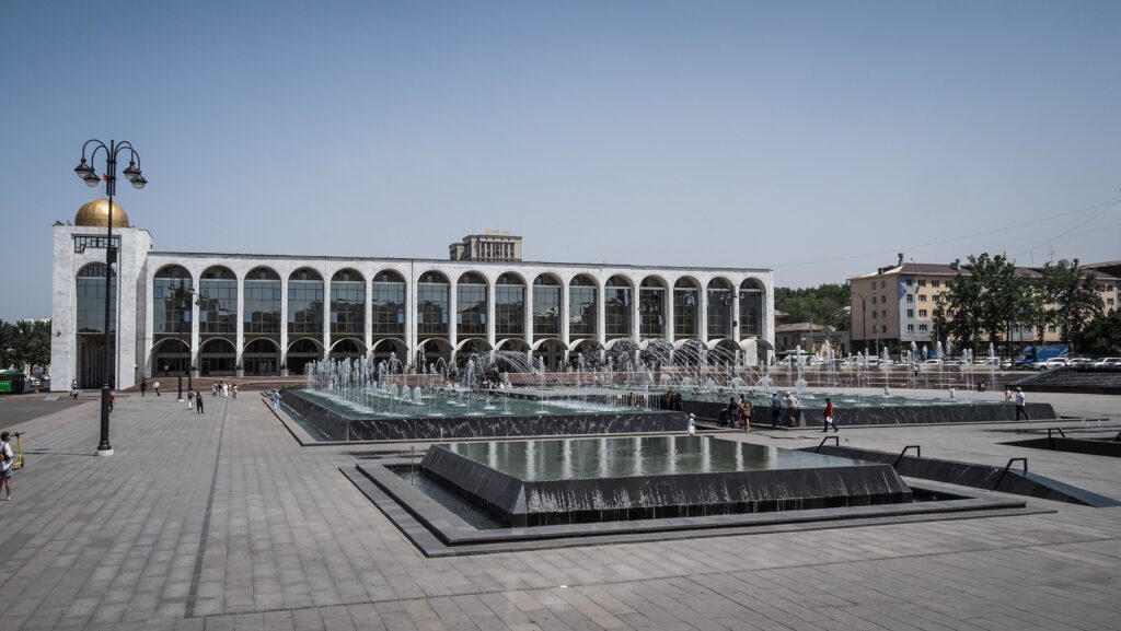
Ala-Too Square
This is Bishkek’s central square and the main gathering point for public life. It’s where parades, festivals, and national celebrations take place. The square is framed by government buildings, fountains, and monuments, making it a symbolic heart of the capital. In the evenings, it becomes lively with locals strolling and families enjoying the open space.
Ala Too Square
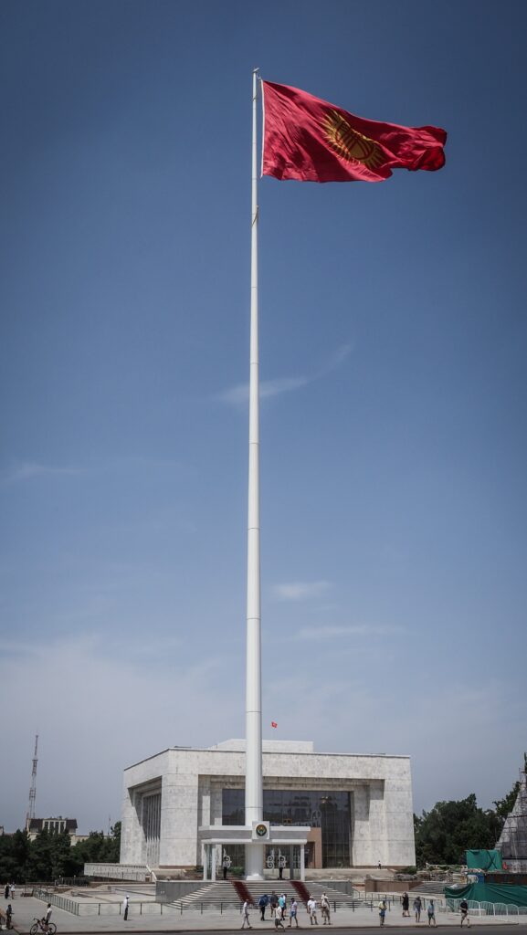
Paramount Kyrgyz Republic Flag
This is one of the tallest flagpoles in the country, standing prominently in central Bishkek near Ala-Too Square. The massive flag of Kyrgyzstan waves high above the city, making it both a patriotic symbol and a striking landmark. Visitors often stop here for photos because of the scale of the flag and its importance as a national emblem.
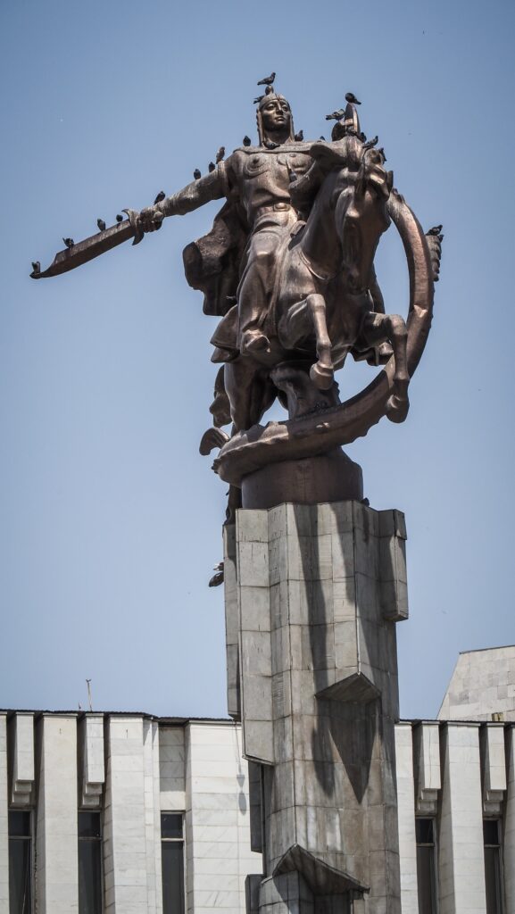
Next to the flag stands a large monument dedicated to Manas, the legendary epic hero of Kyrgyz folklore. Manas represents bravery, unity, and leadership, and his story has been passed down for centuries in oral tradition. The statue shows him in a commanding pose on horseback.
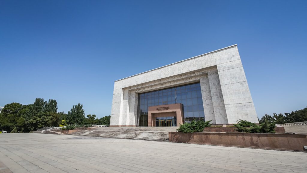
State History Museum
Right on Ala-Too Square, this museum provides insight into Kyrgyzstan’s long past, from ancient nomadic cultures to the Soviet era and beyond. Its exhibits cover archaeology, ethnography, and political history, giving visitors a broad sense of how the nation has developed through the centuries.
State History Museum
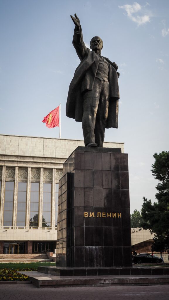
Vladimir Lenin Statue
Although many Soviet monuments have been removed across the region, Bishkek still preserves a large statue of Lenin. Once placed prominently in Ala-Too Square, it has since been moved behind the State History Museum.
Panfilov Park
This leafy park is one of the city’s favourite green spaces. It features tree-lined paths, amusement rides, and a relaxed atmosphere. Families, couples, and students gather here, especially in warmer months, to enjoy a casual day outdoors.
Kurmanzhan Datka Statue
Kurmanzhan Datka (1811–1907) is remembered as one of Kyrgyzstan’s most influential historical leaders. Born in the mountainous Alay Valley, she rose to prominence in a time when women rarely held authority. After the death of her husband, she assumed leadership and earned the respected title of “Datka,” which was used for high-ranking commanders and governors in the Kokand Khanate.
She became known not only for her ability to lead but also for her skills as a negotiator. During the 19th century, when the Russian Empire was expanding into Central Asia, she managed to maintain a degree of stability for her people by pursuing diplomacy instead of open resistance, which would likely have brought destruction.
Kurmanzhan Datka was admired for her sense of justice and her concern for the welfare of her community. Because of her strength and wisdom, she earned the nickname “Queen of the South.”
Oak Park
One of Bishkek’s oldest parks, known for its shaded avenues and outdoor art installations. Sculptures, fountains, and benches make it a pleasant place to stroll. The park also hosts cultural events and provides a refreshing green escape right in the city centre.
Gapar Aitiev National Museum of Fine Arts
This museum houses a wide range of visual art, from traditional Kyrgyz felt works and crafts to paintings and modern art pieces. Named after Kyrgyzstan’s first professional artist, it offers a window into both local creativity and the influence of broader art movements.
M. V. Frunze Museum
Dedicated to Mikhail Frunze, a Bolshevik leader born in Bishkek (then Pishpek), this museum showcases his personal belongings, documents, and the role he played in Soviet history. The building itself is notable because it was constructed around the house where Frunze grew up, preserving it inside.
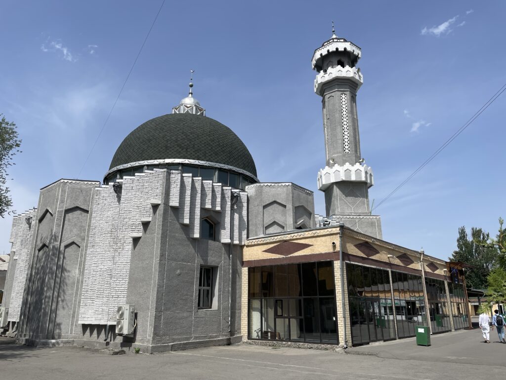
Old Central Mosque
This is one of the city’s oldest Islamic landmarks, dating back to the late 19th century. It’s smaller than the new mosque but carries a lot of historic weight. For many years it served as the main place of worship before the grand new mosque was built. People still gather here, especially older generations who have a connection to it.
Old Central Mosque
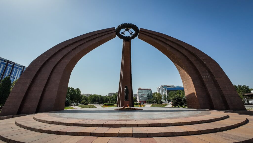
Victory Square
Located right in the city center, this square honors the Soviet victory in World War II. At its heart is a striking monument shaped like a yurt frame, symbolizing both Kyrgyz heritage and the mothers who waited for their sons to return from war. Eternal flames burn here, and it’s a place where ceremonies and quiet moments of remembrance often take place.
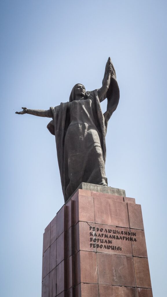
Fighters of the Revolution Monument
This monument is dedicated to those who took part in the 1917 revolution and the turbulent years that followed. It’s a heavy Soviet-style memorial, meant to show strength and sacrifice.
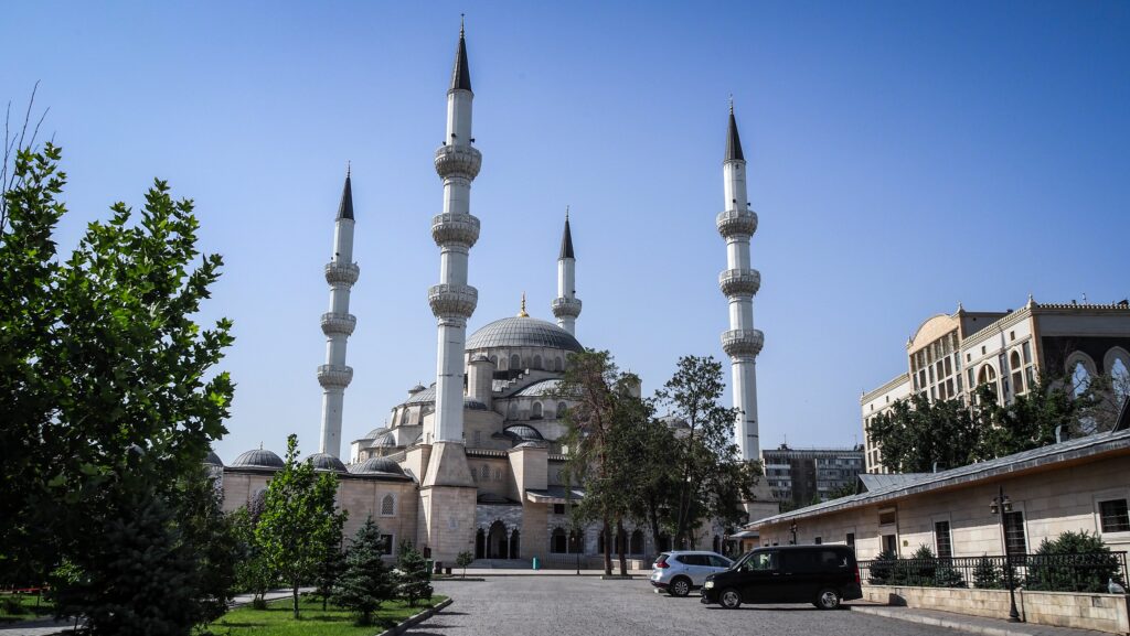
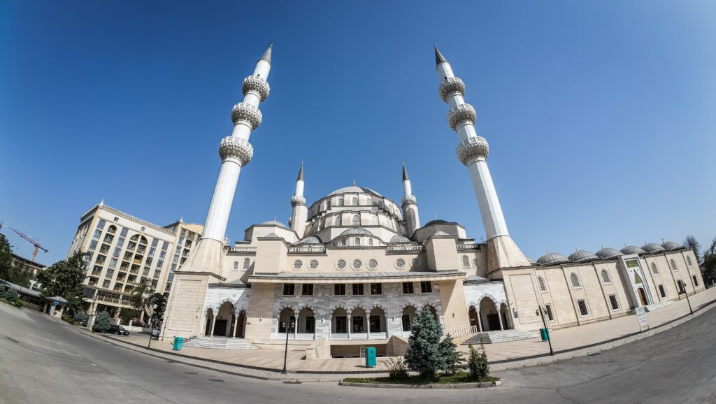
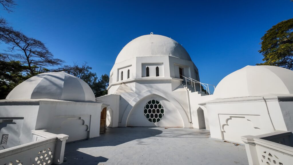
Bishkek Central Mosque
Opened in 2018, this is now the largest mosque in Central Asia. A gift from Turkey, it was built in a grand Ottoman style, white marble, elegant domes, tall minarets. It can hold tens of thousands of worshippers. During Friday prayers and big holidays, the courtyard overflows with people.
Bishkek Central MosqueBishkek Central Mosque
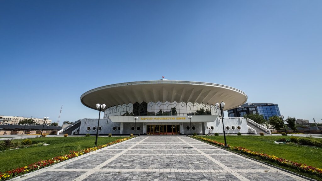
Kyrgyz State Circus
Housed in a round, space-age style building from the 1970s, the circus is pure Soviet architecture. It’s still operating, with performances ranging from traditional acrobatics to animal acts. Even if you don’t go inside, the quirky building itself is a reminder of how Soviet planners loved futuristic designs.
Kyrgyz State Circus
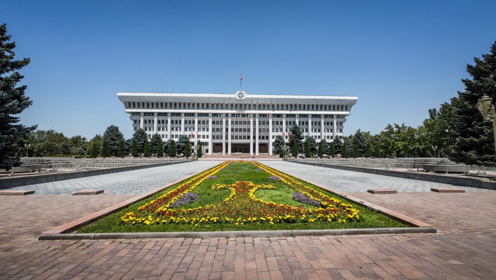
The White House
No relation to Washington’s White House, this one is a government building in Bishkek. A huge block of white marble, very Soviet in appearance, it once served as the headquarters of the Communist Party. Today it’s home to the presidential administration. The area around it has been the stage for protests and revolutions in Kyrgyzstan’s recent history.
The White House
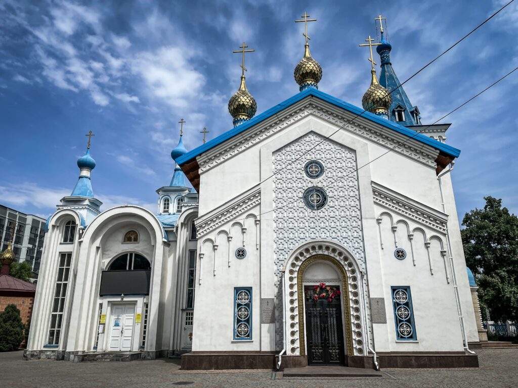
Holy Resurrection Cathedral
A traditional Russian Orthodox cathedral with blue domes and golden crosses, built in the early 20th century. It survived the Soviet period when many churches were closed or destroyed. Today it’s an active church, especially busy on Orthodox holidays.
Holy Resurrection Cathedral
Manas Statue
Manas is the legendary hero of Kyrgyz epic poetry and the symbol of national pride. His statue stands tall near Philharmonia Square, with Manas on horseback, sword raised. It’s a popular meeting spot and one of the key symbols of Bishkek.
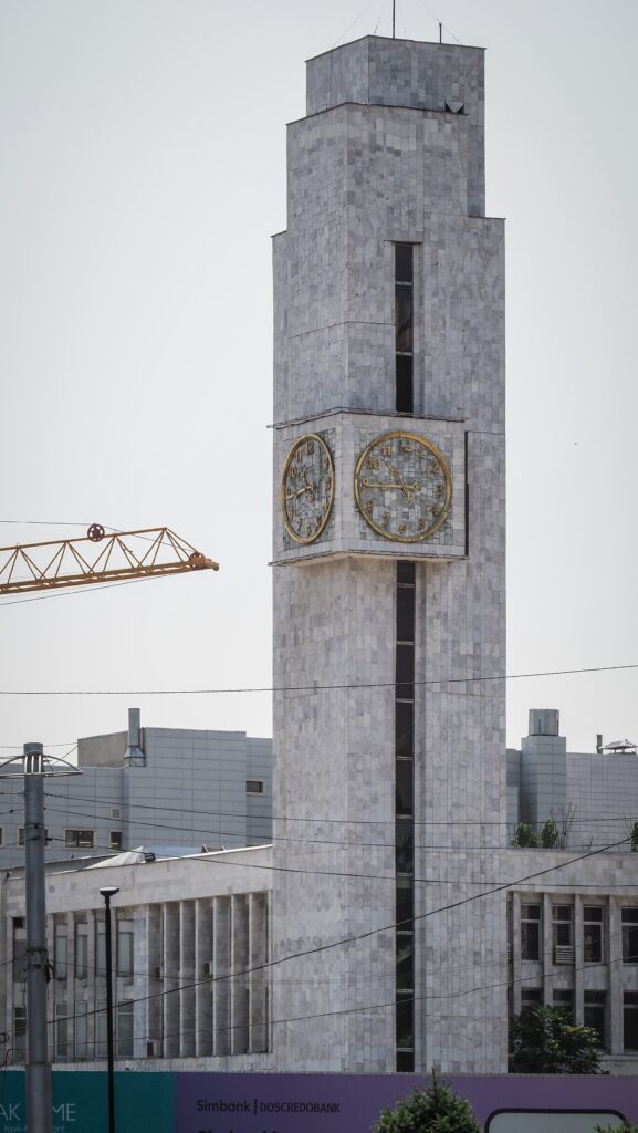
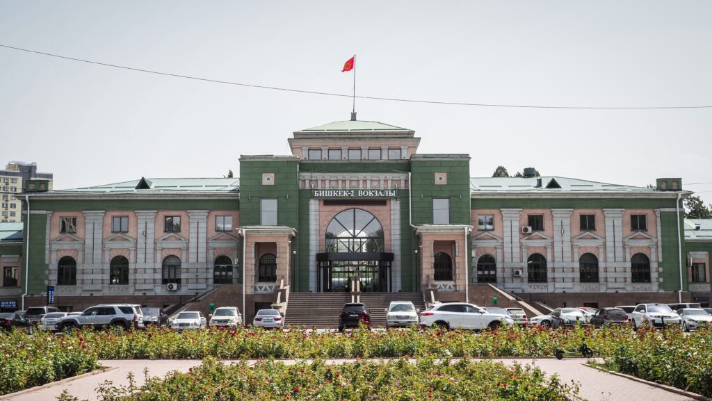
Bishkek Railway Station
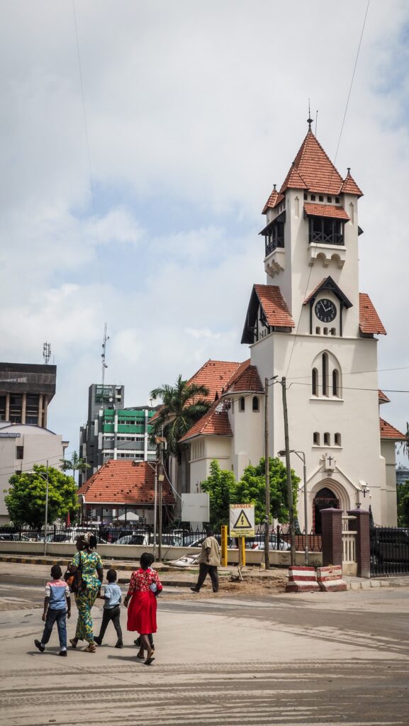
Built in the 1940s, the station is modest but elegant, with Soviet-era design elements. The clock tower is a local landmark, and the station still has an old-world atmosphere, even though air travel has overtaken rail in popularity.
Bishkek Railway Station
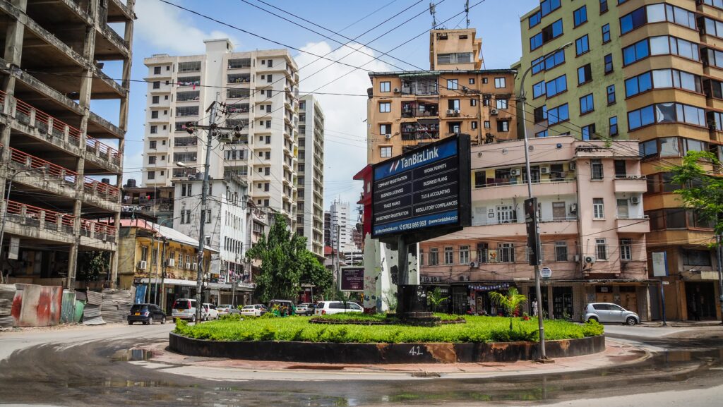
Osh Bazaar
One of the liveliest places in Bishkek. Here you’ll find everything from fresh produce and spices to traditional hats (kalpaks), household items, and clothes. It’s noisy, crowded, and full of character. For visitors, it’s the best spot to experience the everyday hustle of Kyrgyz life, bargain with vendors, and taste local street food like samsa and fresh bread. Be careful as the place is infamous for pickpockets!
What to see outside of Bishkek?
Ata Beyit Memorial
Located a short drive south of Bishkek, this site is both a cemetery and a memorial complex. It honours victims of Stalinist purges in the 1930s, many of whom were buried in mass graves here. Later, the cemetery was expanded to include graves of cultural and political figures, including the famous writer Chingiz Aitmatov. The place is solemn and reflective, set against a backdrop of mountains, making it significant for understanding Kyrgyzstan’s 20th-century history.
The guide in the museum was very nice and he played the movie for me, very often stopping it and giving English commentary.
Flag of Kyrgyzstan at Boz-Boltok Mountain
On Boz-Boltok Mountain, visitors can find an enormous flag of Kyrgyzstan flying proudly. The site offers sweeping views over Bishkek and the surrounding valley. It has become a popular spot for both locals and tourists. The climb or drive up adds a touch of adventure to the visit.
Chon Aryk Mountain
Chon Aryk is located near Bishkek and is more of a natural escape than a tourist hotspot. It’s a great place for hiking, offering fresh air, open fields, and mountain scenery that isn’t far from the city.
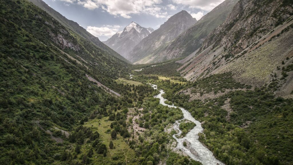
Alamedin Valley
Alamedin Gorge is located in the Kyrgyz Ala-Too range, which is part of the northern Tian Shan Mountains. The gorge stretches along the Alamedin River and is known for its steep, rocky slopes, alpine meadows, and pine forests.
The area is popular for hiking, horseback riding, and camping. Trails lead to waterfalls and higher mountain passes that connect to other valleys. Because of its relatively close location to Bishkek (about 30 kilometres away), it’s one of the more accessible natural escapes for locals and visitors.
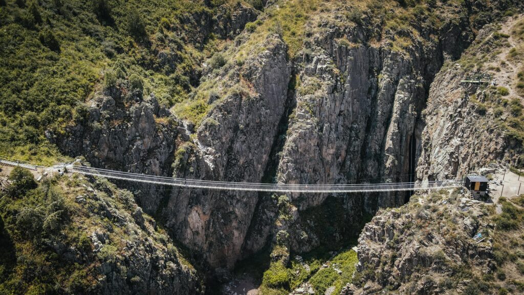
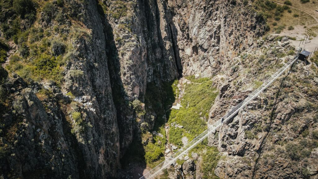
The Sky Bridge is located in the Chunkurchak Gorge, about 35 km from the centre of Bishkek. It was built in 2021 and has quickly become a popular attraction for both locals and visitors. The bridge spans approximately 125 meters and is suspended at an elevation of roughly 2,400 meters above sea level. What makes it especially striking is the drop beneath it, around 700 meters down into the gorge, giving anyone who crosses an intense mix of breathtaking views and adrenaline.
This park is one of the most famous natural attractions near Bishkek, just about 40 km away. Nestled in the Tian Shan mountains, it’s a haven for outdoor lovers. Visitors come for day or multiday hikes, picnics, and to admire glaciers, waterfalls, and alpine landscapes. Because it’s so close to the city, it’s a favourite weekend getaway for Bishkek residents looking for fresh air and dramatic scenery. Luckily, the majority of them don’t go any further than the end of the asphalt road, so you can be sure to find peace by going a bit further into the park.
Read more about hiking in the park in the separate post HERE.
The Sky Bridge is located in the Chunkurchak Gorge, about 35 km from the centre of Bishkek. It was built quite recently, around 2021, and has quickly become a popular attraction for both locals and visitors. The bridge stretches for about 125 meters and is suspended at an altitude of roughly 2400 meters above sea level. What makes it especially striking is the drop beneath it, around 700 meters down into the gorge, giving anyone who crosses an intense mix of breathtaking views and adrenaline.
How to get there?
Most people travel there by car; the drive usually takes around an hour, depending on traffic and road conditions. The route heads south from Bishkek, first along paved roads and then gradually into more mountainous terrain. The last stretch into the gorge includes some winding roads and can be a bit rough in places, so a vehicle with decent clearance is recommended, especially during wet or snowy weather.
Public transportation doesn’t go directly to the bridge, so visitors who don’t drive often rely on taxis, private drivers, or organised tours. If you travel independently, you can order a taxi through the Yandex App. Some local tour companies combine the Sky Bridge with other attractions in the Ala-Archa or Chunkurchak area, which makes it easier for travellers without their own transport.
The best time to visit
The best time to visit the Sky Bridge near Bishkek is generally from late spring through early autumn. During this period, the gorge is at its most scenic, with green meadows, wildflowers, and clear skies that make the views especially dramatic. Summer months are warm but not too hot at higher elevations, which makes walking across the bridge more comfortable.
In contrast, winter brings heavy snow and icy conditions in the mountains. While the landscape looks spectacular, access can be difficult, and the roads leading up to the gorge may become challenging or even unsafe without proper vehicles. Early spring can also be tricky, as melting snow makes the roads muddy and slippery.
Where to stay in Bishkek?
During my several-day stay in Bishkek, I stayed in five different hotels:
Inter Hotel Bishkek: Probably the best price-to-quality ratio. Good locations, modern room.
Hotel Touristan: The room was huge and clean. The receptionist was super helpful, and I even received a fridge magnet as a gift. The only negative was that the AC didn’t work too well.
Malinka: More like a guesthouse rather than a hotel. The room was well equipped with a kettle, tea, sugar, and toiletries. Very friendly owner who let me leave a part of my luggage for several days as I was hiking in Ala Archa National Park.
Terrasse Hotel & Bar: A luxurious establishment offering stunning panoramic views of the mountains and the city. I had to get a really good deal on booking.com as in the next days the rooms became 4 times more expensive.
Is it worth it?
From the bridge and the surrounding hills, you’re treated to beautiful mountain panoramas. One of the highlights you can spot from up there is the Golubinyy Waterfall. It’s possible to hike down to its base, but the trail is quite steep, so extra caution is needed.
As for the Sky Bridge itself, it makes a great stop along the way to Chunkurchak Valley, adding a touch of adventure to the journey. That said, it’s probably best enjoyed as part of a broader trip rather than the sole reason to head out there.
Alamedin Gorge is located in the Kyrgyz Ala-Too range, which is part of the northern Tian Shan Mountains. The gorge stretches along the Alamedin River and is known for its steep, rocky slopes, alpine meadows, and pine forests.
The area is popular for hiking, horseback riding, and camping. Trails lead to waterfalls and higher mountain passes that connect to other valleys. Because of its relatively close location to Bishkek (about 30 kilometres away), it’s one of the more accessible natural escapes for locals and visitors.
Flora and fauna are rich here: you can find juniper, wildflowers in spring and summer, and various mountain animals such as marmots and birds of prey. In winter, the gorge is snow-covered, making it suitable for ski touring.
How to get to Alamedin Gorge?
By Private Car
From Bishkek, head south along the Alamedin Road. After about 20–30 kilometres, you’ll reach the entrance to the gorge near the village of Koy-Tash. From there, the road continues deeper into the valley, though it becomes narrower and less paved the further you go.
By Public Transport
Shared taxis and minibuses (marshrutkas) regularly run from Bishkek to Koy-Tash. From there, you can either hike, hitchhike or hire local transport to reach deeper into the gorge.
By Taxi
You can use the Yandex App and order a private taxi all the way to the trailhead.
Tours
Some local travel companies and guesthouses arrange day trips, often including stops at the hot springs, waterfalls, or guided hikes.
The best time to visit
Spring (April–June)
This is when the valley comes alive. Snow begins to melt, the river swells, and meadows fill with wildflowers. Trails can still be muddy or snowy at higher elevations, but the scenery is especially fresh and colourful.
Summer (July–August)
The most popular season. The weather is warm, the riverbanks are green, and it’s perfect for hiking, camping, or horseback riding. You’ll also see yurts set up by shepherd families, since livestock are brought to graze in the high pastures. This is the easiest time to access most trails.
Autumn (September–October)
The gorge is quieter, temperatures are cooler, and the hillsides turn golden and red with autumn colours. It’s a good season for hiking without crowds, though nights can get quite cold.
Winter (November–March)
The gorge becomes snow-covered and much less visited. It’s not the best for hiking, but it’s great if you enjoy winter landscapes, ski touring, or just want a peaceful escape. The hot springs are especially nice when the air is cold.
Where to stay in Bishkek?
During my several-day stay in Bishkek, I stayed in four different hotels:
Inter Hotel Bishkek: Probably the best price-to-quality ratio. Good locations, modern room.
Hotel Touristan: The room was huge and clean. The receptionist was super helpful, and I even received a fridge magnet as a gift. The only negative was that the AC didn’t work too well.
Malinka: More like a guesthouse rather than a hotel. The room was well equipped with a kettle, tea, sugar, and toiletries. Very friendly owner who let me leave a part of my luggage for several days as I was hiking in Ala Archa National Park.
Terrasse Hotel & Bar: A luxurious establishment offering stunning panoramic views of the mountains and the city. I had to get a really good deal on booking.com as in the next days the rooms became 4 times more expensive.
My experience
For my very first trip out of the city, I ordered a Yandex taxi straight to the trailhead of the Alamedin Valley. It is less than an hour from Bishkek, yet it already felt like a whole new world, without traffic jams and air pollution. From the moment I set foot on the path, the scenery was stunning. I chose the trail on the right side of the river, which climbed gently alongside the rushing stream, opening up views of pine-covered slopes and rugged peaks in the distance.
A side path promised a waterfall, so I turned right and hiked upward. Along the way, the valley was alive with marmots chattering from their burrows and darting across the grasslands. The waterfall itself was modest, not quite the dramatic cascade I’d imagined, but the setting more than made up for it. It took me a bit over 2 hours to reach it from the place where I was dropped off by the taxi driver.
I debated pushing on toward the high pastures (jailoo), but the trail ahead looked steep and demanding, so I decided to save that climb for another time. Instead, I wandered deeper into the valley, crossed a small bridge, and sent my drone buzzing overhead to capture the sweeping views before turning back. I later learned that with the right gear and several days, adventurous and experienced trekkers can even reach Ala-Archa National Park from here. However, I couldn’t find sufficient online info about the conditions of the trail.
If you decide to hike to the high pastures, it should take about 2 hours one way, and the trail is visible on Mapy.CZ. On Google Maps, the place is called “At Zhayloo”. Here is the map:
The return journey was just as memorable. I managed to hitch a ride part of the way, then grabbed another taxi back into Bishkek.
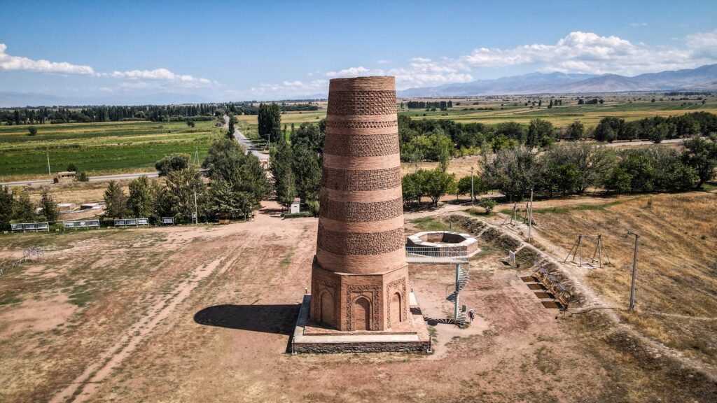
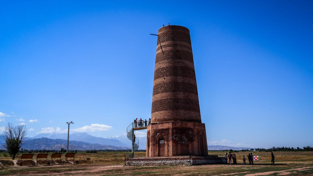
The Burana Tower is a large minaret located near the town of Tokmok in northern Kyrgyzstan. It is one of the most significant historical monuments in the country and a key remnant of the medieval Silk Road era.
The tower was built around the 10th–11th century during the time of the Karakhanid Khanate, a dynasty that ruled much of Central Asia. Originally, it is thought to have stood at around 40–45 meters tall, serving both as a minaret for a mosque and as a symbol of the city of Balasagun, the Karakhanid capital.
Like other minarets, it would have been used for the Islamic call to prayer. Beyond its religious role, towers like Burana also functioned as landmarks for travellers and traders moving along the Silk Road.
Earthquakes over the centuries caused significant damage to the structure. By the 15th century, parts of the tower had collapsed, reducing it to about 25 meters, which is its current height. The surrounding city of Balasagun eventually declined and was abandoned, leaving the tower standing in isolation.
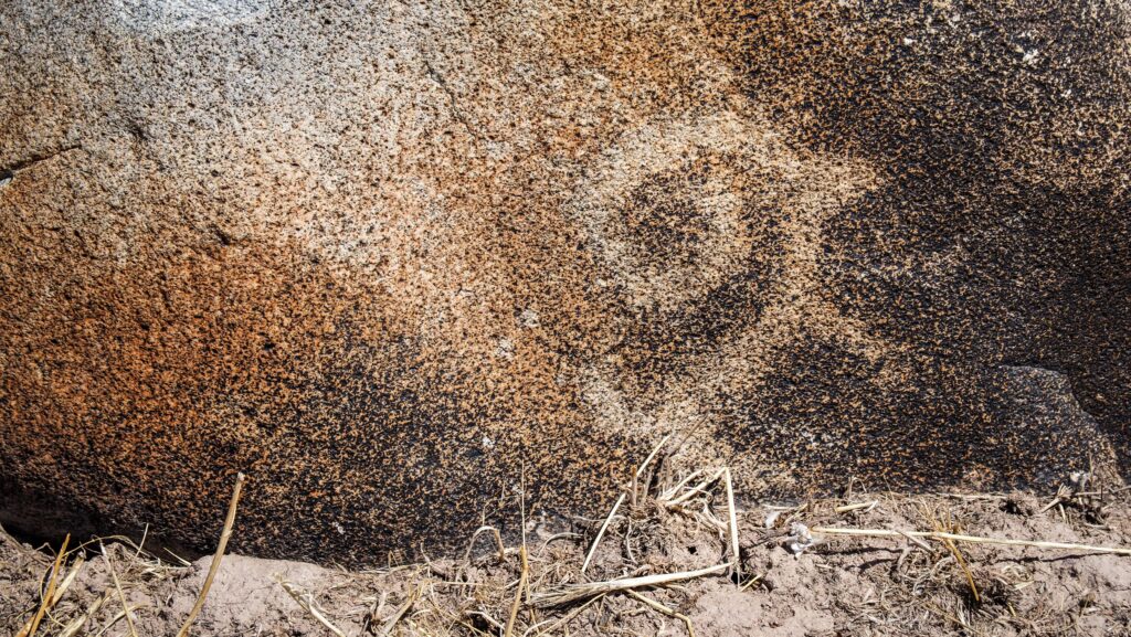
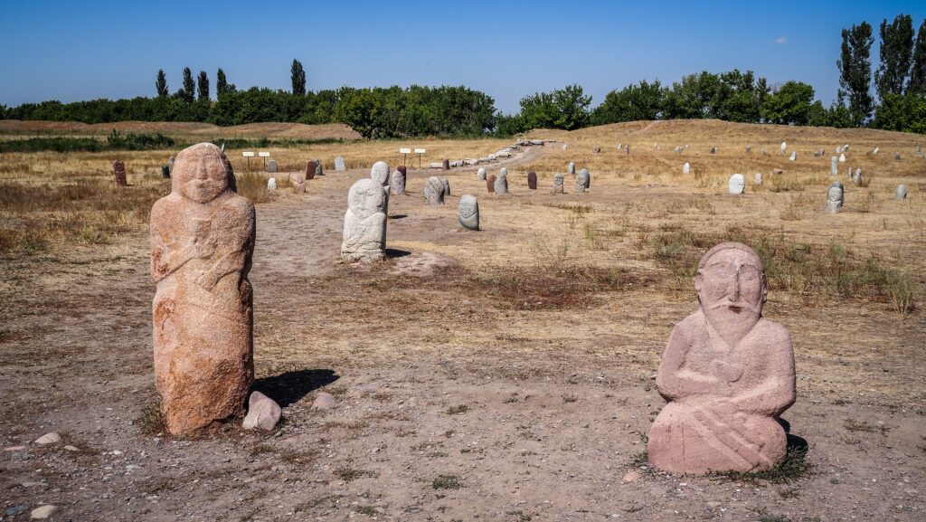
In the 20th century, restoration work was carried out to stabilise the structure and prevent further collapse. Today, visitors can climb a steep internal staircase to reach the top and look over the Chüy Valley. Around the tower, there is also a collection of balbals (ancient stone statues) and artefacts from the region.
Burana Tower
How to get to Burana?
By Car
Drive east from Bishkek on the A365 highway toward Tokmok. Once in Tokmok, follow the signs to Burana, which is about 12 km south of the town.
By Minibus
Go to the Eastern Bus Station in Bishkek. Take a marshrutka heading to Tokmok or Balakchy / Cholpon Ata (tell the driver to drop you off at the turn off to Tokmok). In Tokmok, hire a taxi to take you to the Burana Tower (I highly recommend using the Yandex App). Ask the driver to wait for you, or you will need to hitchhike back to town, as ordering a taxi from the app may be very difficult at this location.
Tours
Many agencies in Bishkek offer half-day or full-day tours to Burana Tower, often combined with other nearby attractions. Convenient if you want a guide to explain the history.
PetrogryphBurana Tower
The best time to visit
Spring (April–June)
The valley is green and full of flowers, making the views from the top of the tower especially beautiful. The weather is mild (around 15–25°C), comfortable for climbing the tower and walking around the site.
Summer (July–August)
Warm to hot (25–35°C). It can feel scorching since the site has very little shade. Still popular because many tourists visit Kyrgyzstan in summer. If you go, it’s best to visit in the morning or late afternoon to avoid the midday heat.
Autumn (September–October)
Another excellent time: mild temperatures and golden landscapes in the Chüy Valley. Fewer tourists compared to summer, so it feels calmer.
Winter (November–March)
Cold (sometimes below 0°C) with snow possible. Very few visitors, so you may have the place almost to yourself. Climbing the tower’s narrow steps can be slippery and difficult in snow or ice.
Where to stay in Bishkek?
During my several-day stay in Bishkek, I stayed in four different hotels:
Inter Hotel Bishkek: Probably the best price-to-quality ratio. Good locations, modern room.
Hotel Touristan: The room was huge and clean. The receptionist was super helpful, and I even received a fridge magnet as a gift. The only negative was that the AC didn’t work too well.
Malinka: More like a guesthouse rather than a hotel. The room was well equipped with a kettle, tea, sugar, and toiletries. Very friendly owner who let me leave a part of my luggage for several days as I was hiking in Ala Archa National Park.
Terrasse Hotel & Bar: A luxurious establishment offering stunning panoramic views of the mountains and the city. I had to get a really good deal on booking.com as in the next days the rooms became 4 times more expensive.
What are the stone statues near the tower?
Balbals are carved stone figures, often stylised and human-like. They were placed on graves or burial mounds by nomadic Turkic peoples as early as the 6th century. Many represent warriors or ancestors, sometimes holding a cup, weapon, or other symbolic object.
They are believed to honour the dead, especially warriors, and serve as guardians of the spirit world. Some scholars suggest they may also represent enemies defeated in battle, symbolically serving the deceased in the afterlife. Each statue has unique features, reflecting local styles and the person it commemorates.
Zanzibar is a semi-autonomous region of Tanzania, made up mainly of two islands: Unguja (often called Zanzibar Island) and Pemba, along with several smaller islets. It’s located in the Indian Ocean, just off the coast of East Africa. The islands have a long history as a trading hub, especially for spices, ivory, and slaves, which gave Zanzibar the nickname “Spice Islands.”
Culturally, Zanzibar reflects a mix of African, Arab, Persian, and Indian influences, visible in its architecture, cuisine, and traditions. Stone Town, the historic centre of Zanzibar City, is a UNESCO World Heritage Site known for its narrow streets, carved wooden doors, and vibrant markets.
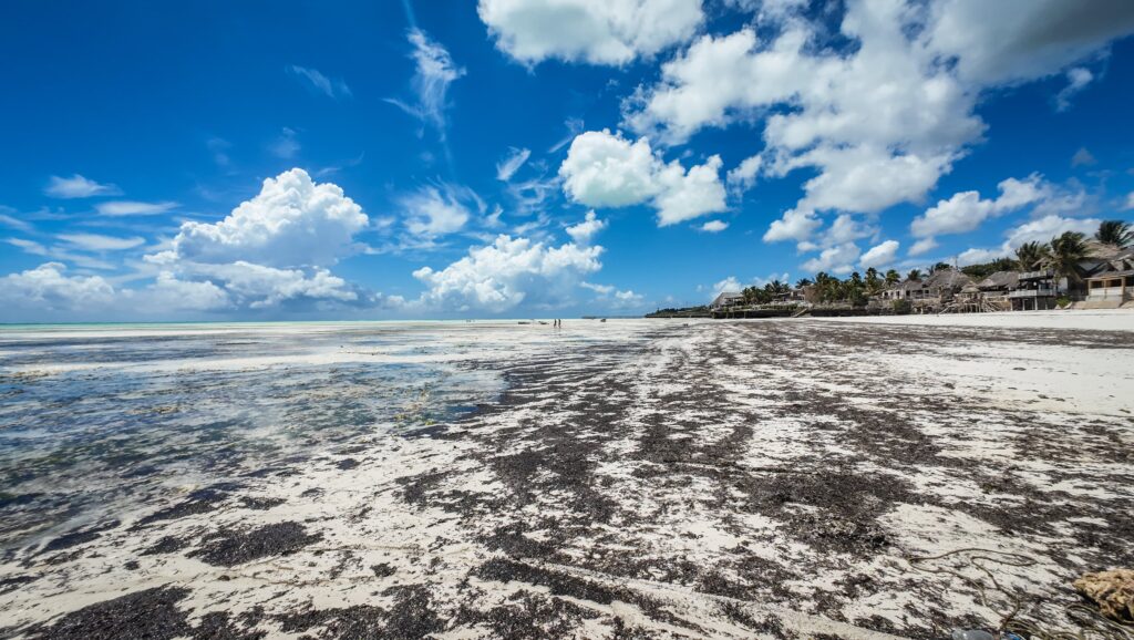
Today, Zanzibar is famous for its pristine beaches, coral reefs, and spice plantations, making it a popular tourist destination while also maintaining its role in fishing and agriculture. I don’t like visiting touristy places which don’t have much more to offer than the beach, but after travelling for nearly 3 months in mainland Tanzania, I decided to give Zanzibar a chance.
The history of Zanzibar
Zanzibar’s history stretches back thousands of years, shaped by its strategic position in the Indian Ocean. Long before modern states existed, sailors and merchants from Arabia, Persia, India, and the African mainland used the islands as a stopover for trade. Over time, Zanzibar became a melting pot where cultures blended through commerce, migration, and settlement.
By the Middle Ages, Arab traders had established settlements, and Islam became deeply rooted in local society. Persian influences also appeared, particularly through the Shirazi people, who are said to have migrated and integrated with the Swahili-speaking communities. Zanzibar’s language, Swahili, grew out of this fusion of African Bantu roots and Arabic influences.
In the 17th century, Zanzibar came under the control of Oman. This period marked the height of the islands’ role in the global spice and slave trade. Clove plantations were introduced, worked largely by enslaved labourers, and Zanzibar became one of the main hubs for the trafficking of people from East Africa to the Middle East and beyond.
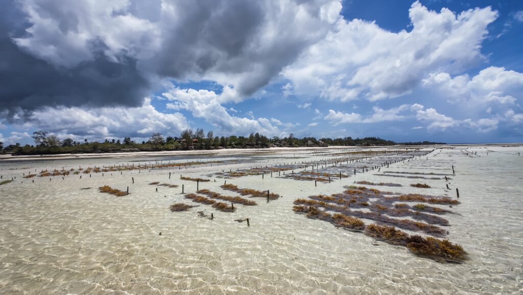
Seaweed farm
By the 19th century, Zanzibar was powerful enough to be the seat of the Omani Sultanate. In fact, the sultan moved his court from Muscat to Zanzibar in 1840, solidifying its importance. This made Stone Town flourish as a cosmopolitan centre of wealth and diplomacy, though it also meant the slave trade expanded drastically.
European colonial powers soon turned their eyes to Zanzibar. The British, in particular, exerted increasing influence, pressuring the sultanate to abolish slavery and eventually establishing the islands as a protectorate in the late 19th century. Zanzibar briefly became infamous in 1896 when it was the site of the world’s shortest war, lasting less than an hour, after the British bombarded the palace to enforce their authority.
After decades under colonial control, Zanzibar gained independence in 1963, only to undergo a revolution the following year. The uprising overthrew the sultanate, leading to major social upheaval. Soon after, Zanzibar merged with mainland Tanganyika to form the United Republic of Tanzania in 1964, though it retained a semi-autonomous government with its own president and legislature.
How to get there?
By Air
International flights: Zanzibar’s Abeid Amani Karume International Airport (ZNZ) receives direct flights from some major cities in Europe, the Middle East (like Doha, Dubai, Muscat), and East Africa. Many travelers also connect through Nairobi (Kenya), Addis Ababa (Ethiopia), or Doha (Qatar).
From mainland Tanzania: Frequent domestic flights connect Zanzibar with Dar es Salaam, Arusha, and Kilimanjaro. The flight from Dar es Salaam is only about 20–30 minutes.
By Ferry
From Dar es Salaam: High-speed ferries run daily between Dar es Salaam and Zanzibar City (Stone Town). The trip usually takes around 2–2.5 hours. Ferries are operated by companies like Azam Marine. Cars can also be transported on cargo ferries, though most visitors leave vehicles on the mainland.
The beach in Zanzibar
The best time to visit
Peak Season (June – October)
Clear skies, low humidity, and warm temperatures make this the ideal time for beach holidays and outdoor activities. It also lines up well with safari season in mainland Tanzania, so many travelers combine the two.
Prices for hotels and tours are higher, and popular spots can feel busier.
Shoulder Season (November and March)
Fewer crowds, lower rates, and still plenty of sunshine, though you might get the occasional shower. November is especially good for diving since visibility is strong.
Short rains can happen, but they’re usually quick and not disruptive.
Rainy Seasons (April–May and November)
Lush landscapes and fewer tourists. Accommodation prices are at their lowest.
Heavy rainfall in April and May can make beach time and travel tricky. Some hotels close for maintenance during this period.
Stone Town and the Islands
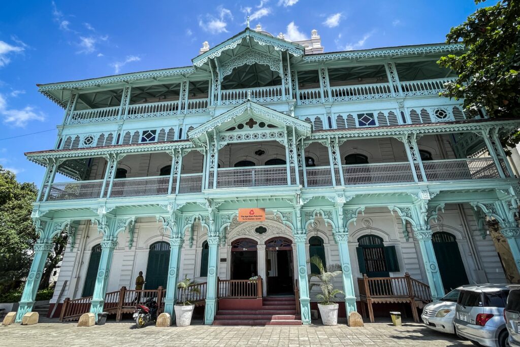
Old Dispensary
A striking four-story building on the waterfront, decorated with carved balconies and stained glass. It was originally intended as a charitable medical facility and it still acts as a hospital. The staff is very nice and they let you have a look inside and check out old photographies.
Old Dispensary
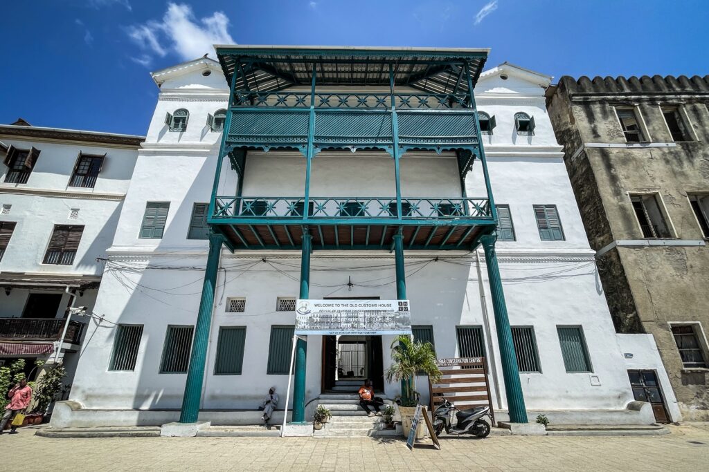
Old Customs House
Once the hub of Zanzibar’s bustling trade, especially during the clove and spice boom. Its central location near the harbour makes it a key landmark in Stone Town’s commercial past.
Old Customs House
House of Wonders
Built by Sultan Barghash in 1883, it was the first building on the island with electricity and an elevator. As of March 2025, it was undergoing restoration, but it remains one of the most iconic landmarks of Zanzibar.
Old Fort
Constructed in the 17th century by the Omanis to defend against the Portuguese, it now serves as a cultural centre, with an amphitheatre, craft shops, and festival events.
Princess Salme Museum
Dedicated to Princess Salme, who fled Zanzibar in the 19th century to marry a German merchant. The museum focuses on her writings and the clash of cultures in her life story.
Freddie Mercury Museum
Located in his childhood home, this small but popular museum celebrates the early life of Queen’s legendary frontman. The ticket is way too expensive, taking in the considering the value that you can find inside (mostly pictures).
Museum of Natural History
Once a school, it became a museum highlighting the island’s wildlife and natural environment.
Peace Memorial Museum
Built during the British Protectorate in a striking domed style, it was once the main national museum of Zanzibar, with exhibits on history, archaeology, and ethnography.
Peace Memorial Museum
Forster Gallery
A smaller cultural venue showcasing art and local heritage, often featuring exhibitions related to Zanzibar’s diverse communities.
Saint Joseph’s Cathedral
A late 19th-century Catholic church with twin spires, built by French missionaries. It remains one of the tallest and most photographed landmarks in Stone Town.
Christ Church Cathedral
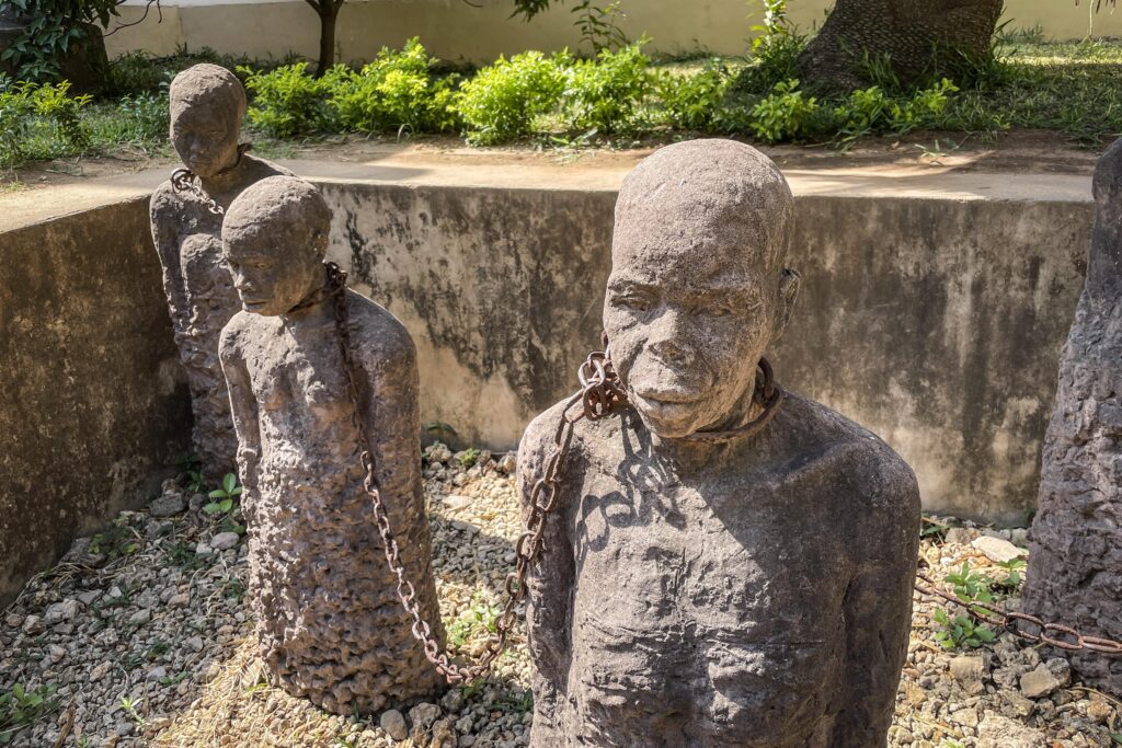
It was built on the site of Zanzibar’s former slave market. The church itself is a major symbol of abolition, and the adjacent East Africa Slave Trade Exhibition gives a powerful account of this dark chapter.
East Africa Slave Trade Exhibition
Located within the old slave chambers, it documents the history of slavery in Zanzibar and the wider region. At first, you are joined by the guide and at the end of the tour, you get the time to read and explore information boards independently. Very interesting!
East Africa Slave Trade Exhibition
Hamamni Persian Baths
It was built in the late 19th century by Sultan Barghash for public bathing. Though no longer functioning, the vaulted rooms and underground passages are still impressive. In March 2025, it was closed for renovation, but workers let me in to have a look for a small fee.
Jaw’s Corner
A lively square in the heart of Stone Town where locals gather for coffee, discussions, and news.
Darajani Bazaar
Stone Town’s main market, bustling with stalls selling spices, seafood, meat, and fresh produce. It’s both a shopping destination and a cultural experience.
The Forodhani of Zanzibar
A waterfront park that transforms in the evenings into a famous open-air food market, known for seafood grills, Zanzibari pizzas, and sugarcane juice. It’s nice to walk around, but I don’t recommend eating there as it is a typical tourist trap with low-quality food but high prices.
Shangani Public Beach
A small but central beach near the Old Fort and House of Wonders, often busy with locals and children swimming at sunset.
Old Portuguese Arch
A remnant of the island’s Portuguese era, serving as a small but symbolic piece of Stone Town’s layered history.
High Court
A colonial-era structure still in use as part of Zanzibar’s judiciary.
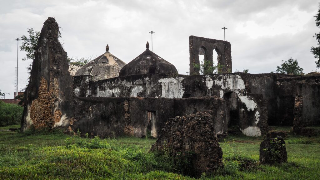
Maruhubi Historical Sites
These ruins belonged to Sultan Barghash and were originally built as a palace and harem. Although damaged by fire, the gardens, aqueducts, and stone remnants still suggest its former splendour. There should be a guardian on site who can open it for you. Needless to say, you need to negotiate the entrance ticket price to avoid being ripped off. You don’t need more than 15 minutes to see everything.
MaruhubiLow tide near Maruhubi Ruins
Mtoni Palace Ruins
The remains of a grand 19th-century palace built for Sultan Said. Princess Salme, one of Zanzibar’s most famous historical figures, lived here in her youth. The site is mostly ruins now, and you can be shown around by a local guide hanging out there.
Mtoni Palace Ruins
Kibweni Palace Museum
Located just outside Stone Town, this palace was once tied to the Omani sultans. Today, it functions as a small museum that gives insight into royal life and Zanzibar’s Omani heritage.
Kibweni Palace MuseumThe beach near Kibweni Palace Museum
Kidichi Spice Farm
Zanzibar is famous as the “Spice Island,” and Kidichi is one of the best places to experience that legacy. Located inland, it is a traditional spice plantation where visitors can see, smell, and taste spices like cloves, cinnamon, nutmeg, and vanilla. Guided tours usually involve walking through the plantation while learning about the cultivation and uses of each plant.
Changu Island
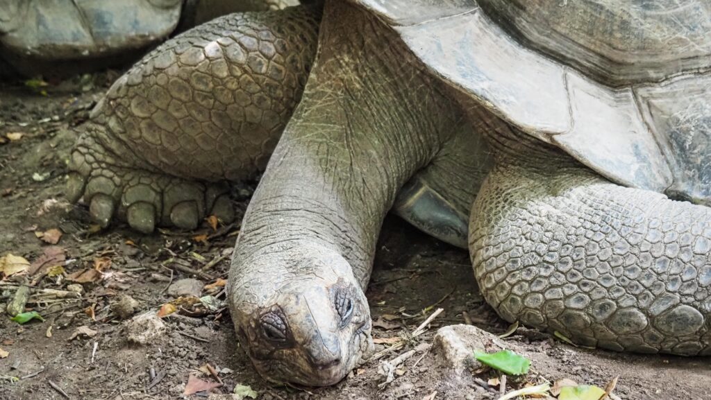
Often nicknamed Prison Island, Changu lies just a short boat ride from Stone Town. Despite the name, it was never really used as a prison for locals. It was intended as a detention site for rebellious slaves and later became a quarantine station for yellow fever. Today, its main draw is the population of giant Aldabra tortoises, some over a century old. Other than that, there is nothing much to see or do.
Changu Island
Bawe Island
This small coral island sits west of Stone Town and is less crowded than other destinations. Bawe is popular with snorkelers and divers. There is a high-end resort in case you want to stay overnight in a luxurious place.
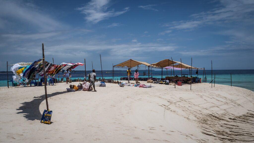
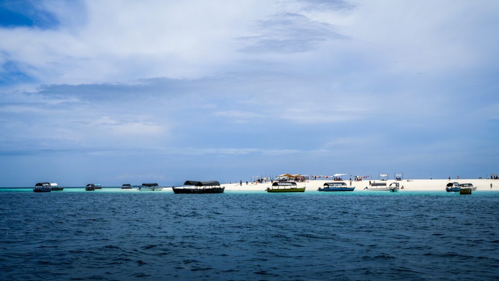
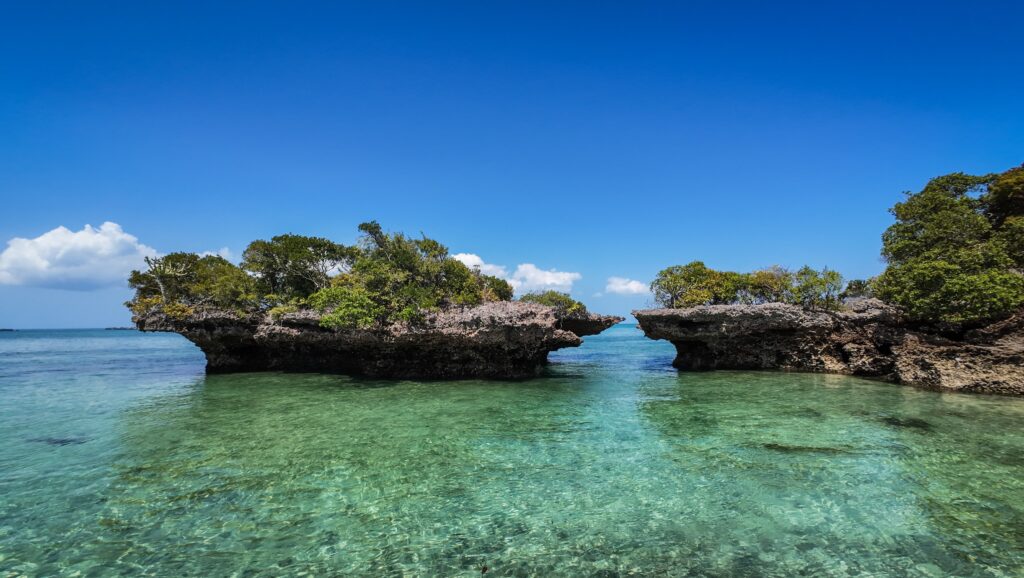
Nakupenda Sandbank
“Nakupenda” means I love you in Swahili, and this sandbank certainly lives up to the name. It’s a stretch of white sand that appears at low tide just off the coast of Stone Town. There are no permanent structures, just a strip of sand surrounded by turquoise water. Day trips usually combine snorkelling, sunbathing, and fresh seafood picnics prepared by guides.
Nakupenda SandbankNakupenda Sandbank
Chumbe Island
Chumbe is a protected marine reserve and eco-lodge, about 12 kilometres from Stone Town. The island is best known for its coral reef sanctuary, which is considered one of the most pristine in the region. However, the high costs of visiting, even for a day trip, make it rather unworthy.
Chapwani Island
This private island is smaller and more low-key. Chapwani has mangroves, small beaches, and shallow reefs. It is also historically significant as it houses a small cemetery for British naval officers from the 19th century. The island is home to a boutique lodge, so you will have to stay there to explore the surroundings.
The North
Nungwi Beach
Nungwi Beach is one of Zanzibar’s most famous stretches of coastline. The sand is bright white and very fine, and the turquoise waters are calm, especially at low tide. Unlike many beaches on the east coast of Zanzibar, Nungwi is less affected by tidal changes, so you can swim almost any time of day. It’s also a lively area with beach bars, restaurants, and plenty of opportunities for activities like snorkelling, diving, or sunset cruises in traditional dhow boats.
Nungwi Beach
Zanzibar Aquarium
This small but unique aquarium isn’t the typical glass-tank kind. Instead, it’s a natural lagoon that serves as a conservation project for injured or endangered sea turtles. Visitors can learn about local marine life and even help release rehabilitated turtles back into the ocean at certain times of the year. I had mixed feelings while feeding the turtles, which seemed to be a tourist attraction. I hope they are really released back into the ocean, but the reality may not be that positive.
Royal Beach
Royal Beach is a quieter spot near Nungwi, often associated with the upscale resorts in the area. It has a more relaxed atmosphere compared to the main beach and is great if you’re looking for less crowded sunbathing and a more polished, resort-style vibe. The waters here are also ideal for swimming, and the sunsets are spectacular.
Kendwa Beach
Located just a short drive or walk south of Nungwi. It is considered one of the most beautiful beaches in Zanzibar. It has the same white sands and clear water, but with an even more laid-back feel. Kendwa is especially famous for its full moon parties, which bring together travellers and locals for music and dancing under the stars. Outside of those nights, it’s calm and perfect for swimming, paddleboarding, or simply lounging.
Dolphin Boat Trip
From Nungwi, you can join boat trips that take you offshore to spot dolphins, particularly near Mnemba Atoll or other parts of the northern coast. These trips often include snorkelling in coral-rich waters, where you can see colourful fish and maybe even sea turtles. While it’s thrilling to see dolphins in the wild, it’s good to choose operators that follow responsible practices and avoid chasing or stressing the animals. That is the difficult part. Tourists jump into the water while the boat driver sees the dolphins passing by.
The ruins are remnants of a 16th-century Swahili settlement. Walking among the stone structures, you can see traces of old houses and walls, which give you a glimpse of how people lived centuries ago on Zanzibar’s northern coast.
The cave nearby is a natural limestone formation with a pool of clear water inside. Local communities have traditionally used it as a freshwater source, and today it remains a quiet spot for exploration. Unfortunately, the experience is ruined by the scammers who sell the way overpriced ‘tickets’ and try to rip off the tourists. Don’t let them fool you and either negotiate the price or just skip this place.
Fukuchani Ruins
Muyuni Beach
Muyuni is a quiet, untouched stretch of beach facing Mnemba Island. It has some of the softest white sand and shallow, clear waters, making it excellent for swimming and snorkelling. Because it’s less developed than Nungwi or Kendwa, you won’t find as many crowds. Local fishermen still use the area, so you get a glimpse of everyday coastal life.
Mnemba Island
Just offshore, Mnemba is a small private island known for its marine reserve. While staying on the island itself is limited to luxury guests, day trips from nearby beaches let you enjoy the waters around it. Snorkelling and diving here are great, with colourful fish, and sometimes dolphins or turtles. The island is often used as a picture-perfect backdrop for boat excursions.
Mnemba Island
Matemwe
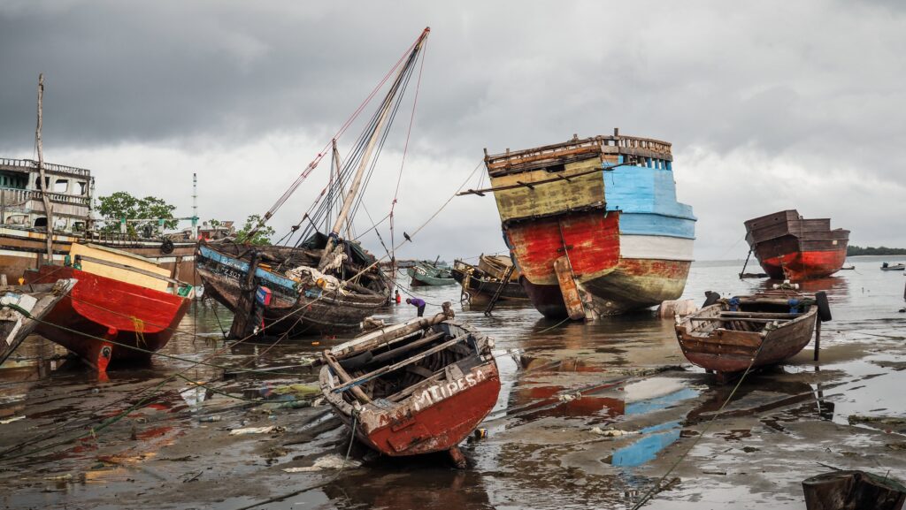
Matemwe village and beach are located opposite Mnemba. The village has a strong fishing culture, and you’ll often see locals mending nets or heading out to sea.
Kiwengwa Beach
Kiwengwa is sometimes called the “Little Italy” of Zanzibar because of its popularity with Italian visitors and resorts. The beach itself is long and wide, great for long walks, water sports, or just lounging. The tidal changes here are dramatic: at low tide, you can walk far out into the reef, while at high tide, the water comes right up to the beach.
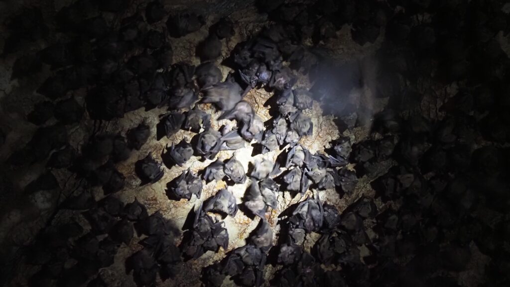
Kiwengwa Caves
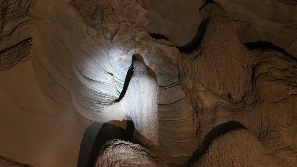
These caves are part of Zanzibar’s limestone landscape and have a history of being used by local communities for shelter and rituals. Today, they’re managed as a small heritage and eco-site. Inside, you’ll find impressive stalactites and stalagmites, as well as a sense of mystery. Visiting requires going through the community-managed entrance and getting a guide.
Kiwengwa Caves
Pongwe Beach
The bay is naturally protected by a reef, creating a lagoon-like setting with gentle waters. Unlike busier beaches, Pongwe has fewer resorts, so it keeps a quiet, intimate feel. Hammocks strung between palm trees and views of the turquoise sea make it one of Zanzibar’s best spots for pure relaxation.
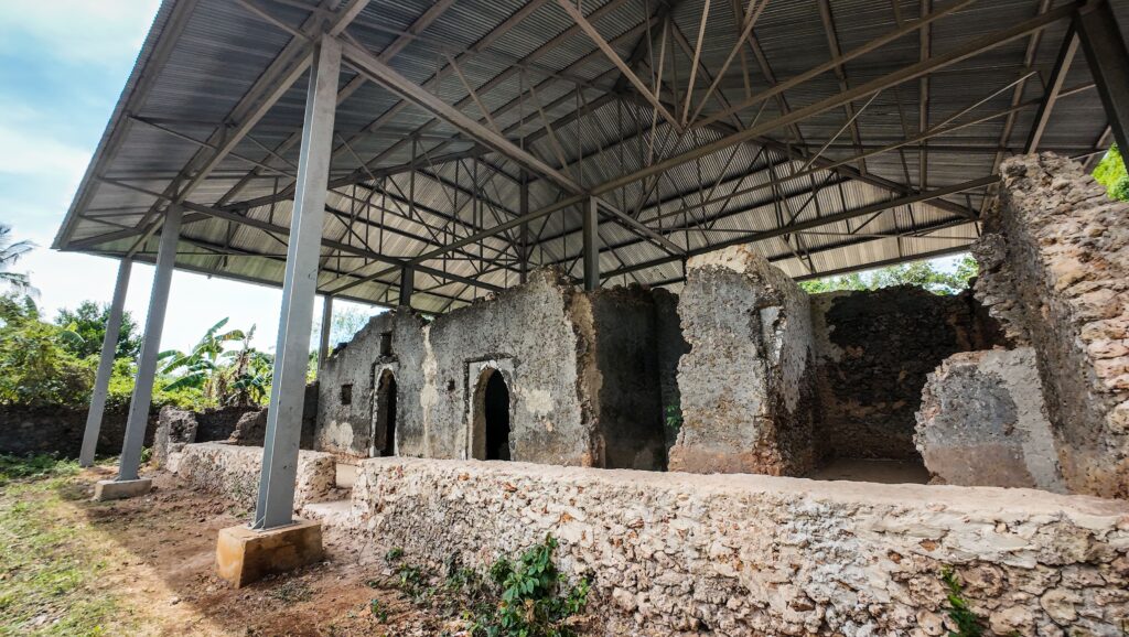
Mangapwani Slave Chamber
This is a historical cave chamber linked to Zanzibar’s slave trade past. It was used in the 19th century to hold enslaved people before they were secretly shipped out after the trade was officially abolished. The guide there can explain the history, and you walk down into the cool, dim stone chamber. The surrounding area also has scenic coastal views.
Second World War Bunker
Nearby, you can also find a remnant from the Second World War, a bunker built during the conflict. Though simple in appearance, it’s an unusual sight in Zanzibar and a reminder of the island’s strategic importance in the Indian Ocean during that time. Unfortunately, it was inaccessible during my visit there in March 2025.
The South
Michamvi Sunset Beach
This spot on the southeastern peninsula is famous for its golden sunsets over Chwaka Bay. Unlike most of Zanzibar’s east coast, which faces sunrise, Michamvi gives you the rare chance to watch the sun sink directly into the ocean. The beach itself is calm and not too crowded, but as of March 2025, there was a lot of construction going on.
Pingwe Beach
Pingwe is best known as the home of “The Rock” restaurant, perched dramatically on a coral outcrop just offshore. The beach around it is quiet and picturesque, with shallow turquoise water at low tide and deeper blues at high tide. It’s a great stop for photos and for enjoying a long meal with a view.
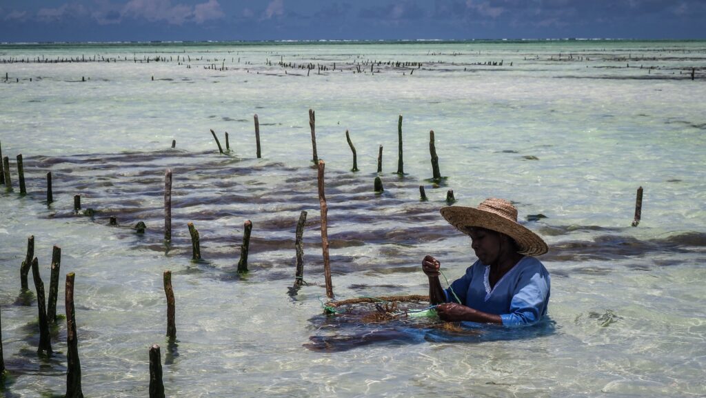
Mwani Zanzibar
This is a seaweed farm and women’s cooperative near Paje. Visitors can learn how seaweed is harvested, dried, and turned into products like soaps, lotions, and natural cosmetics. It’s both an educational experience and a way to support local women-led businesses. Walking among the seaweed plots during low tide gives a unique glimpse of coastal livelihoods.
Mwani ZanzibarMwani Zanzibar
Paje Beach
Paje is one of Zanzibar’s liveliest beaches and a hub for kitesurfing. The steady winds and shallow lagoon make it a world-class spot for the sport. Beyond that, it’s a social place with beach bars, hostels, and guesthouses, drawing backpackers and younger travellers.
Kuza Cave
A hidden natural limestone cave near Jambiani with a pool of crystal-clear water inside. The cave is considered sacred by some local communities, and the cool water makes it a refreshing place to swim.
Kuza Cave
Maalum Cave
The cave itself is a limestone sinkhole filled with clear, turquoise water that has filtered naturally through the surrounding rock. It’s sheltered and shaded, so the water stays cool even on hot days. The cave is deep enough for swimming, not just wading, and the light filtering through the opening makes the water glow beautifully.
There is a restaurant and other infrastructure on site, and they also provide you with a towel, water shoes, swimming mask and snorkel. However, all of that comes ata price of 20 USD per person.
Maluum Cave
Jambiani Beach
This beach south of Paje has a quieter, more traditional feel. The fishing village atmosphere is strong here: you’ll see locals pushing their canoes or women collecting seaweed. The beach is long and beautiful, with fewer crowds.
Jambiani Sandbank
Just offshore, there’s a sandbank that appears at low tide. Boats can take you there, and it becomes a dreamy little island of white sand surrounded by turquoise sea.
Makunduchi Beach & Lighthouse
Further south, Makunduchi is a wide, tranquil beach with almost no development compared to the more touristy areas. The lighthouse stands at the tip of the southern coast and provides panoramic views but as of March 2025, there was no one site to let us climb to the top.
Mtende Beach
Mtende is one of Zanzibar’s most dramatic coastal landscapes. Huge cliffs frame a small beach, with Mtende Rock rising like a giant sculpture in the water. At low tide you can walk around and explore tidal pools, while at high tide, the beach disappears almost completely.
Mtende Beach
Kizimkazi Mkunguni
This fishing village on the southwest coast is famous for dolphin tours, though it also has historical significance. There’s an ancient mosque here, one of the oldest in East Africa, dating back many centuries.
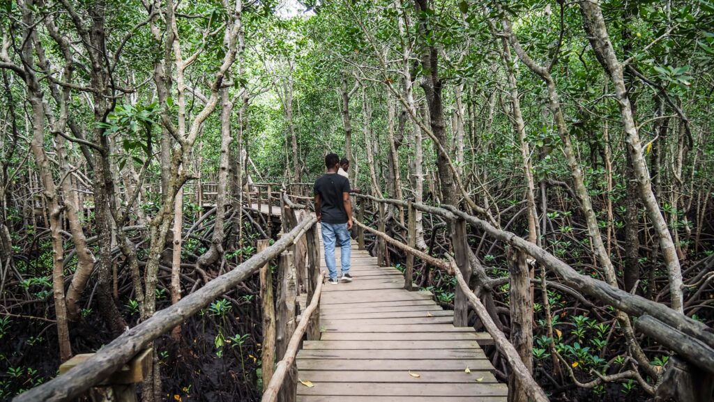
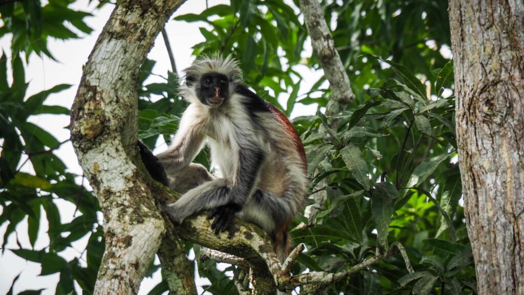
Jozani Forest National Park
Located in central Zanzibar, this is the island’s only national park and home to the rare red colobus monkey, found only here. Walking trails lead you through mangrove boardwalks, mahogany trees, and forest. For me, it was the most overpriced and disappointing experience in Zanzibar. Yes, we saw red colobus, but it had nothing to do with a hike in the forest, as we were very close to the tarmac road and there were lots of farmlands.
Jozani Forest National ParkJozani Forest National Park
Historic House of Bi Khole
This restored 19th-century house belonged to Princess Sayyida Bi Khole, a daughter of Sultan Said. Today, it’s a museum showcasing Zanzibari history, architecture, and Arab influences of that era. The house retains many original features and gives insight into how elite families lived at the time. As always, try to negotiate the price as the first ‘offer’ is way too optimistic.
Historic House of Bi Khole
Safari Blue
One of Zanzibar’s most popular day excursions, based around sailing on a traditional dhow boat along the Menai Bay Conservation Area on the south-west coast. The trip usually combines several highlights: snorkelling over coral reefs, spotting dolphins, swimming in a natural lagoon,and relaxing on a sandbank that appears with the tide. The day also includes a seafood barbecue served under the shade of mangroves or palm trees on Kwale Island. I went with the Original Safari Blue Company, and everything was excellent.
Safari Blue
Kwale Island
Kwale is one of the central islands visited on Safari Blue. It’s larger and more lively than Niamembe, with shady baobab trees and sheltered spots for setting up lunch. Many tours use Kwale as the main base, where seafood feasts are prepared and served. The beach is wide and sandy, and at low tide, you can explore tidal pools. The island’s giant ancient baobab tree is a favourite stop for photos and climbing.
Niamembe Island
Niamembe is a small, private-feeling island near the Safari Blue route. It has the kind of unspoiled, soft white sand and calm water that look straight out of a postcard. Few people visit, so it feels like a deserted island when you land. Because of its isolation, the snorkelling around its reefs is excellent, with colourful fish and corals thriving in the clear shallows. Getting there is more expensive as it usually requires a customised dhow trip.
Dar es Salaam is the largest city and main commercial hub of Tanzania, located along the eastern coast of the country on the Indian Ocean. It started as a small fishing village before developing into an important port and trading centre during the 19th century. Later, under German and British colonial rule, it expanded further and eventually became the capital of Tanzania until the government shifted the administrative capital to Dodoma (though Dar es Salaam remains the country’s economic centre).
The name “Dar es Salaam” comes from Arabic, roughly meaning “Haven of Peace” or “Abode of Peace.” It was given in the mid-19th century by Sultan Majid bin Said of Zanzibar, who founded the settlement around 1865. The name reflects the city’s coastal role as both a safe harbour and a welcoming trade hub.
The history of Dar es Salaam
Early Beginnings
Before it became a city, the site of present-day Dar es Salaam was home to small fishing communities along the coast. The sheltered harbour made it a convenient spot for local trade with inland groups and for regional exchanges across the Indian Ocean.
Founded in the 19th Century
In the 1860s, Sultan Majid bin Said of Zanzibar established a settlement there. He gave it the name Dar es Salaam, meaning “Abode of Peace” in Arabic. He aimed to create a new trading town on the mainland that could complement Zanzibar’s commercial dominance. However, after he died in 1870, development slowed and the settlement declined in importance for a time.
German Colonial Era
In the late 19th century, the Germans arrived and made the town an administrative centre for their colony, German East Africa. They developed infrastructure, including roads, government buildings, and the port, and expanded trade routes to connect the interior with the coast. Dar es Salaam grew into a hub for exporting raw materials such as sisal, coffee, and cotton.
British Administration
After Germany’s defeat in World War I, the League of Nations mandated the territory to Britain. Under British rule, Dar es Salaam remained the administrative and commercial centre ofTanganyika. Railways, schools, and hospitals were expanded, and the population continued to rise, attracting African, Arab, Indian, and European communities.
Path to Independence
In the mid-20th century, the city became a focal point for nationalist movements pushing for independence. When Tanganyika gained independence in 1961, Dar es Salaam was the capital. It also became the capital of the newly united Tanzania in 1964, after Tanganyika and Zanzibar merged.
Post-Independence Growth
Even after the Tanzanian government decided in 1973 to relocate the capital to Dodoma (a plan still unfolding decades later), Dar es Salaam retained its dominance as the largest city and economic powerhouse. It has remained the country’s busiest port and a centre of finance, industry, and education.
Modern Era
Today, Dar es Salaam is one of the fastest-growing cities in Africa. It serves as a gateway for trade not only for Tanzania but also for landlocked countries in East and Central Africa, such as Zambia, Malawi, and the Democratic Republic of Congo. The city is a melting pot of cultures, with influences from African, Arab, Indian, and European heritage reflected in its architecture, cuisine, and lifestyle.
How to get there?
By Air
Julius Nyerere International Airport (DAR) is the main gateway. It handles most international and domestic flights.
Direct international connections exist from cities in Africa, the Middle East, Europe, and Asia. You may need a layover in hubs such as Addis Ababa, Nairobi, Doha, Istanbul, or Dubai.
By Sea
Dar es Salaam has a large port that serves both cargo and passenger ferries. There are regular ferries from Zanzibar and other coastal towns. Some cruise ships also stop here.
By Land
Long-distance buses connect Dar es Salaam with major Tanzanian cities such as Dodoma, Arusha, Mwanza, and Mbeya. They also run to neighbouring countries like Kenya, Malawi, and Zambia.
You can drive to Dar es Salaam via Tanzania’s road network, but road conditions vary, so planning and a reliable vehicle are essential.
The Tanzania–Zambia Railway (TAZARA) links Dar es Salaam with Zambia, passing through southern Tanzania. Another line connects the city with central and northern Tanzania.
The best time to visit
Dry Season (June to October)
This is the most popular period for visitors. The weather is warm but less humid, and there’s very little rain. Ideal for beach activities, sightseeing, and trips to nearby islands or game reserves. It also overlaps with the peak safari season in Tanzania, so many travellers combine city visits with wildlife tours.
Hot Season (November to February)
Temperatures rise, and it can feel quite humid, but the city is lively. Good time for cultural experiences and festivals, though beaches may be less comfortable during the hottest days.
Rainy Season (March to May)
This period sees heavy rains, which can cause flooding and make travel less convenient. On the plus side, accommodation prices are usually lower, and the landscape is very green.
Where to stay?
During my several days’ stay in the city, I spent my nights in two budget-friendly accommodations:
Gallivanters Hostel is a budget accommodation in Masaki, but they also offer private rooms with shared bathroom, which are of good price and quality ratio.
Zimbo Golden Hotel is located in the city centre, near Kariakoo Market. The area is quite messy and chaotic, but it remains as authentic as possible, and I felt safe. The room was spacious, but the AC worked poorly. The breakfast included in the price was simple but acceptable.
The streets of Dar es Salaam
What to see in the city?
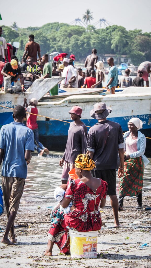
Fish Market
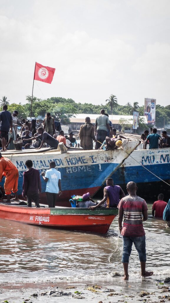
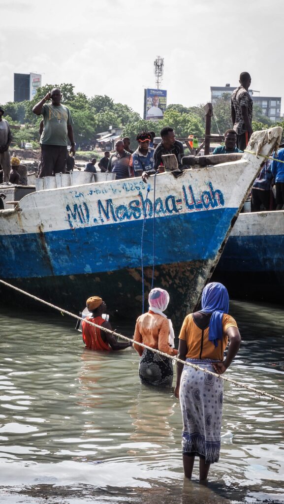
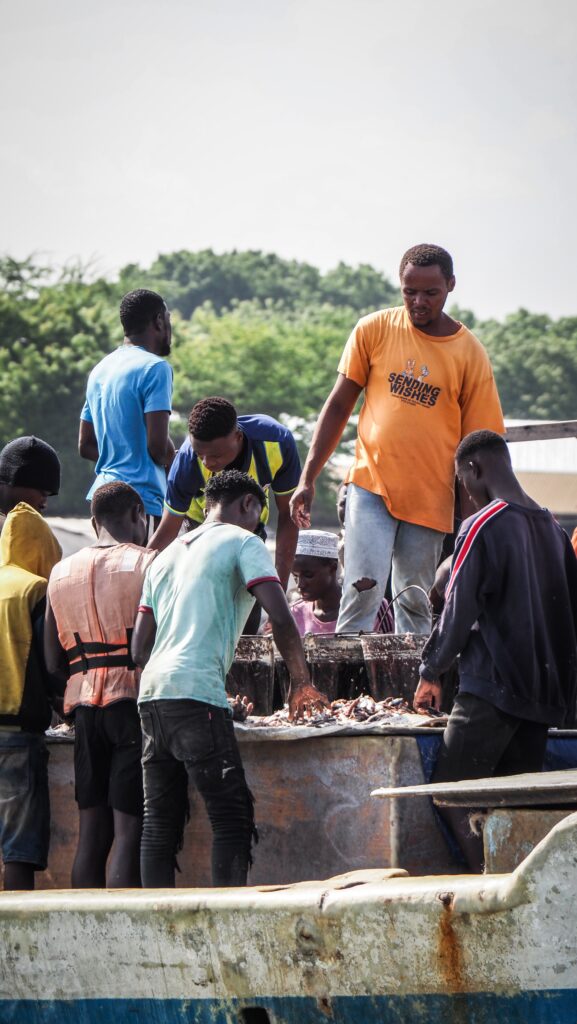
A great way to kick off the morning in Dar es Salaam is with a stop at the bustling Fish Market. At dawn, fishermen unload their fresh catch, turning the place into a lively scene of bargaining, shouting, and excitement. The energy is contagious as boats dock and baskets overflow with seafood. Once you’ve taken in the spectacle, cross over to the other side of Kivukoni Road, where you can sample some of the day’s catch – crispy, freshly fried, and full of flavor.
Azania-Front-Cathedral
It is a historic Lutheran church built during the German colonial period in the late 19th century, when the city was the administrative capital of German East Africa. Its design follows a neo-Gothic style, with a tall steeple, stained-glass windows, and pointed arches that reflect European church architecture of that era.
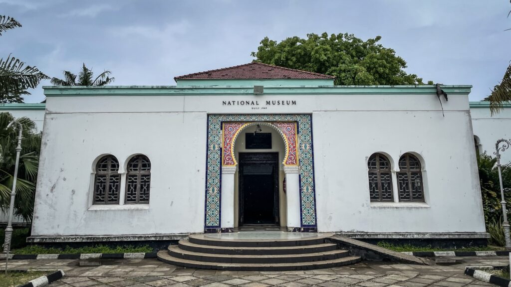
National Museum and House of Culture
The largest museum in Tanzania and an important place to learn about the country’s history, art, and cultural heritage. It was first established in the mid-20th century and has since grown into a center that showcases everything from prehistoric discoveries to modern traditions.
Inside, you’ll find exhibits on human evolution, including fossils linked to the famous finds from Olduvai Gorge, as well as displays on Tanzania’s diverse ethnic groups, colonial history, and the struggle for independence. The museum also features collections of traditional crafts, musical instruments, and contemporary art that highlight the richness of Tanzanian culture.
National Museum and House of Culture
Botanic Gardens
A quiet green escape in the middle of busy town. They were first established during the German colonial era and were used as a testing ground for tropical plants. Though not very large, they make for a pleasant stroll.
Ocean Road Cancer Institute
Built in the early 20th century during German rule, the building originally served as a hospital. Over time, it was transformed into Tanzania’s main cancer treatment and research center. The historic architecture of the institute, set against the Indian Ocean, makes it a striking landmark.
Karimjee Hall
Another notable colonial-era landmarks. Built in the early 20th century with funding from the wealthy Karimjee family, it originally served as the City Hall during the British administration. Its grand architecture, complete with large columns and a distinctive clock tower, reflects the style of civic buildings from that period.
Over the years, Karimjee Hall played a central role in Tanzania’s political history. It even hosted sessions of the country’s parliament before the move to Dodoma. Today, the hall is used for official events, public functions, and sometimes cultural activities.
Asaki Monument
At the crossroad of Samora Ave and Nnamdi Azikiwe Ave stands the Askari Monument. It was unveiled in the 1920s to honor African soldiers who fought in World War I as part of the British colonial forces. The bronze statue shows a soldier holding a rifle, facing toward the harbor, symbolizing both defense and sacrifice.
Azam Roundabout
Not far away is the lively Azam Roundabout, a bustling junction that captures the energy of Dar es Salaam’s downtown. It’s named after the Azam group, one of Tanzania’s largest companies, and the roundabout is surrounded by shops, offices, and heavy traffic. For visitors, it’s less about sightseeing and more about experiencing the pulse of the modern city.
Azam Roundabout
Little India
Around Kisutu Street, you’ll find a neighborhood with strong Indian influences. The streets are lined with spice shops, vegetarian restaurants, textile stores, and jewelry shops. It’s a part of Dar es Salaam where the Indian diaspora’s presence is most visible.
BAPS Shri Swaminarayan Mandir is one of the main centers for the Hindu community. Built in traditional style, it features carved details and shrines dedicated to Hindu deities. It’s a peaceful place of worship and an example of how immigrant communities, especially those of Indian origin, have shaped the cultural fabric of the city.
Another significant Hindu temple nearby is the Shree Shankar Ashram Mandir. Its architecture and colorful interior reflect Indian traditions, and it’s often a hub for cultural events, festivals, and ceremonies.
Old Boma
Built in the 1860s by Sultan Majid of Zanzibar, the Old Boma is one of the city’s oldest surviving buildings. It was originally part of the Sultan’s complex and later used by German colonial administrators. With its coral stone walls and carved wooden doors, it reflects a blend of Swahili and Arab architectural styles. Today, it houses cultural offices and exhibitions.
St. Joseph’s Cathedral
This striking Catholic cathedral was constructed by German missionaries in the late 19th and early 20th centuries. Its Gothic design, complete with tall spires and stained-glass windows, makes it stand out near the waterfront.
Atiman House
Named after Dr. Atiman, a former slave who later became a respected physician, this colonial-era building carries both architectural and human history. It is one of the city’s preserved heritage structures, representing the personal story of resilience.
Kariakoo Market
Lively, crowded, and full of energy, Kariakoo Market is one of the biggest trading centers in Tanzania. It has been a hub for commerce since the early 20th century, when the Germans used the area as a settlement for freed slaves and later developed it into a market. Today, you can find everything here, fresh produce, clothes, household goods, and street food. It’s the kind of place where you feel the true rhythm of everyday life in Dar es Salaam.
Makumbusho Village Museum
An open-air museum that brings Tanzania’s diverse cultures to life. Instead of displaying objects behind glass, it recreates traditional homes from different ethnic groups across the country. Each hut is built using authentic methods and materials, showing how people live in rural areas.
Visitors can walk from one homestead to another, gaining a sense of the variety in architecture, tools, and daily life. Beyond the structures, the museum often hosts live demonstrations such as traditional dances, drumming, and craft-making.
I highly recommend taking a guide from the entrance as there are no descriptions what you are looking at.
Makumbusho Village Museum
Coco Beach
Located along the Msasani Peninsula, it is a popular spot for both locals and visitors. It’s especially lively on weekends when families, food vendors, and musicians gather by the shoreline. While swimming isn’t always ideal due to currents, it’s a great place for people-watching, enjoying street snacks, and catching the sea breeze.
The Slipway
A favorite hangout for expats and travelers, The Slipway is a waterfront complex with restaurants, shops, and a small craft market. It’s also a departure point for boat trips to nearby islands. The setting is relaxed, with beautiful views of the ocean, especially at sunset.
Tinga Tinga Arts Cooperative Society
This cooperative showcases the famous Tinga Tinga painting style, which originated in Tanzania. The art is known for its bright colors and playful depictions of animals and everyday life. At the cooperative, you can watch artists at work, purchase unique pieces directly, and even learn about the history of the movement.
Mwenge Woodcarvers Market
For souvenirs, Mwenge is the place to go. Here, dozens of artisans sell hand-carved wooden masks, sculptures, and household items, often working on their craft right in front of you.
What to see out of town?
Pugu Hills
Southwest of Dar es Salaam, the Pugu Hills offer a mix of forest, hills, and wildlife. The area is home to one of the world’s oldest known forests, where you can find unique plant species, birds, and small animals. Walking trails lead through lush greenery and up to viewpoints overlooking the city and coastal plains. Besides hiking and birdwatching, the hills are also valued for their caves and sacred sites, which carry cultural importance for local communities. There is also a small lake where you can enjoy kayaking.
The site can be reached by taxi ordered from Uber or Bolt. At the entrance, you will have to register and hire a mandatory guide.
Bongoyo Island
A small, uninhabited island, located about 7 kilometers north of Dar es Salaam. It is a popular destination for locals and tourists seeking a peaceful escape from the city.
The island features a mix of coastal vegetation and some baobab trees. Marine life includes tropical fish and occasional sightings of sea turtles and other aquatic species.
There are basic facilities such as a small restaurant that serves freshly caught seafood and drinks. As soon as you arrive, the local guys will approach you with the menu. Choose whatever you want and say at what time you would like it to be served.
Another nearby island which is as well the part of a protected area that helps conserve coral reefs and marine life. Snorkeling and diving around the island reveal colorful corals, tropical fish, and occasionally sea turtles. The atmosphere feels peaceful and unspoiled.
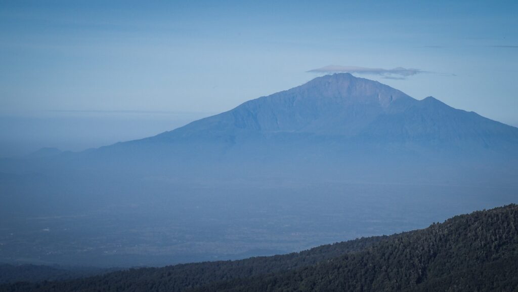
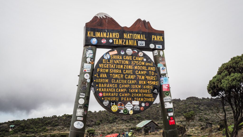
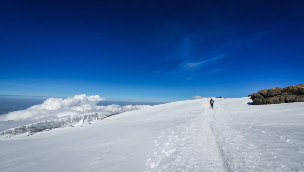
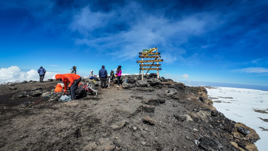
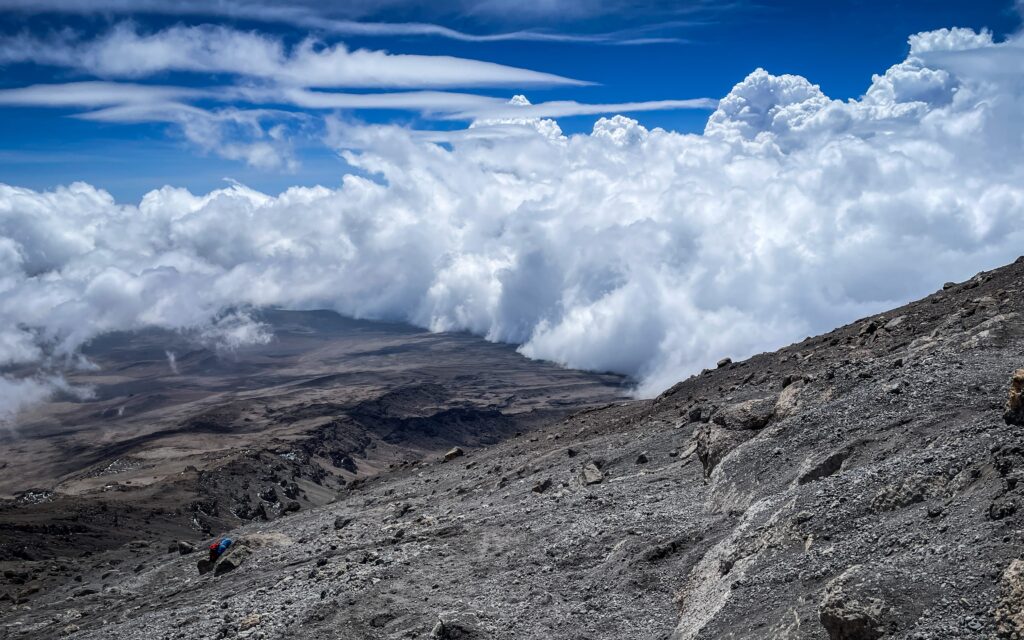
Rising proudly above the plains of Tanzania, Mount Kilimanjaro is the highest peak in Africa. This iconic mountain, crowned with snow despite its equatorial location, is a beacon for trekkers worldwide.
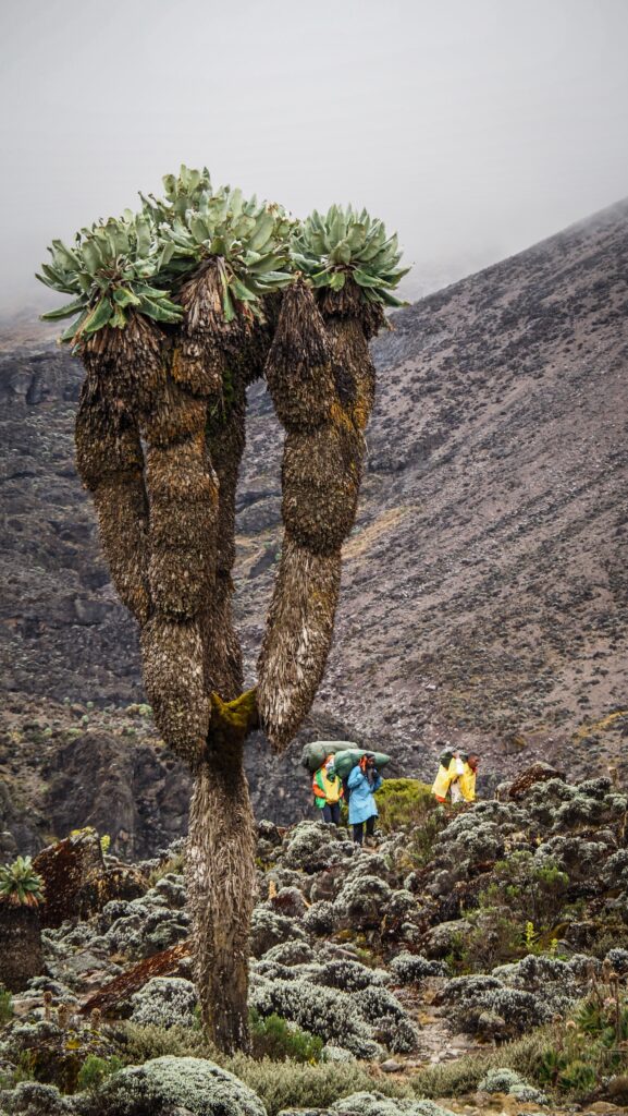
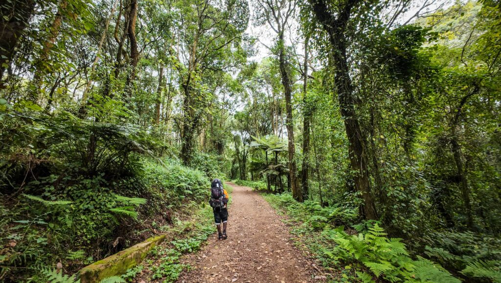
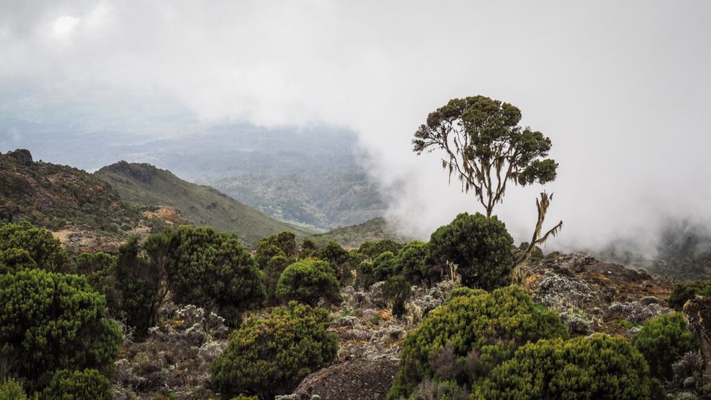
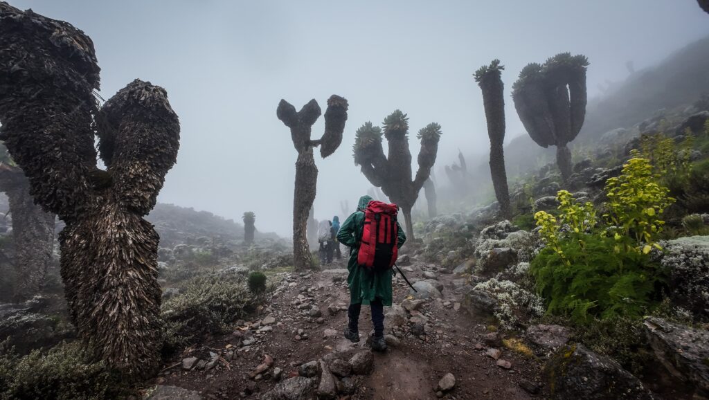
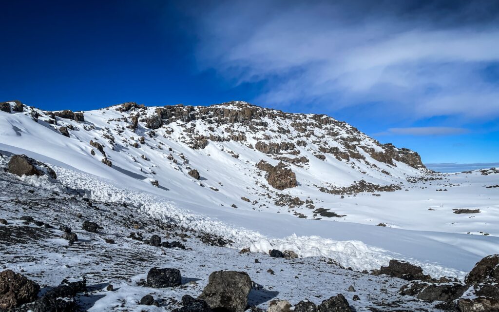
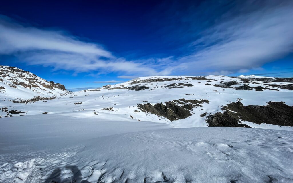
Kilimanjaro offers a journey through a kaleidoscope of landscapes: lush rainforests teeming with life, moorlands dotted with otherworldly plants, arid alpine deserts, and finally the icy summit at the Uhuru Peak. Unlike many high-altitude climbs, Kilimanjaro doesn’t require technical mountaineering skills, making it an accessible challenge for those with determination and a taste for adventure.
The history of Kilimanjaro
Mount Kilimanjaro was formed by powerful geological forces deep within the Earth, shaped over millions of years through volcanic activity. It sits in a region of East Africa known as the Great Rift Valley, where tectonic plates are slowly pulling apart. This shifting of the Earth’s crust created cracks and weaknesses, allowing magma to rise and build the towering mountain we see today.
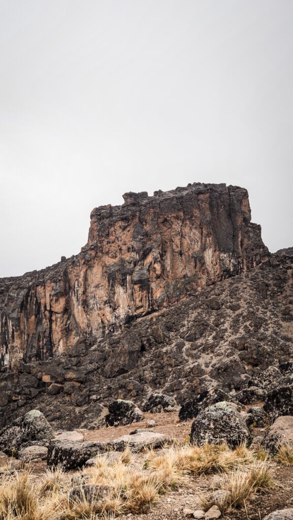
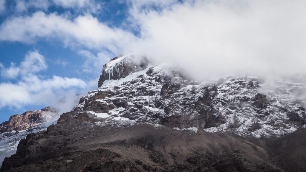
Kilimanjaro is actually made up of three distinct volcanic cones: Kibo, Mawenzi, and Shira. Shira is the oldest and has mostly eroded, forming a plateau. Mawenzi, with its jagged peaks, is the second-highest and no longer active. Kibo, the central and tallest cone, is where Uhuru Peak is located. It’s the youngest of the three and still considered dormant, though it hasn’t erupted in thousands of years.
Over time, repeated eruptions built up layer upon layer of lava and ash, sculpting the massive stratovolcano. Glacial activity and erosion then helped carve the mountain’s current shape, leaving behind its iconic snow-capped summit and rugged terrain.
Long before it became a world-renowned trekking destination, it held deep cultural and spiritual significance for the indigenous Chagga people who live on its lower slopes. They regarded it with reverence, seeing it as a sacred place tied to myths, ancestral stories, and natural power.
The mountain remained largely a mystery to the outside world until the 19th century, when European explorers and missionaries began documenting its snow-capped peak, something that seemed impossible so close to the equator. One of the first widely noted accounts came from German missionary Johannes Rebmann in 1848, whose reports of snow were initially met with scepticism in Europe.
During the colonial era, Kilimanjaro fell under German control as part of German East Africa, and later came under British rule after World War I. In the early 20th century, it became a symbol of exploration and imperial ambition, with the first recorded successful summit made by Hans Meyer and Ludwig Purtscheller in 1889. Their expedition opened the door for future climbers and sparked interest in the mountain worldwide.
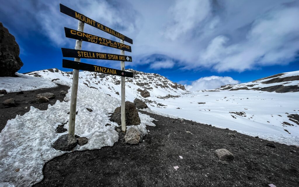
In 1961, just before Tanzania gained independence, Kilimanjaro took on a new symbolic role. A torch was carried to the summit and lit there as a gesture of freedom and unity, representing a new dawn for the nation. Today, the mountain is not only a national treasure but also a UNESCO World Heritage Site, drawing trekkers, scientists, and conservationists who continue to study and protect its unique ecosystems.
Routes
Mount Kilimanjaro offers several routes to the summit, each with its own character, scenery, and level of difficulty. Choosing the right one depends on your fitness, experience, and how much time you can commit.
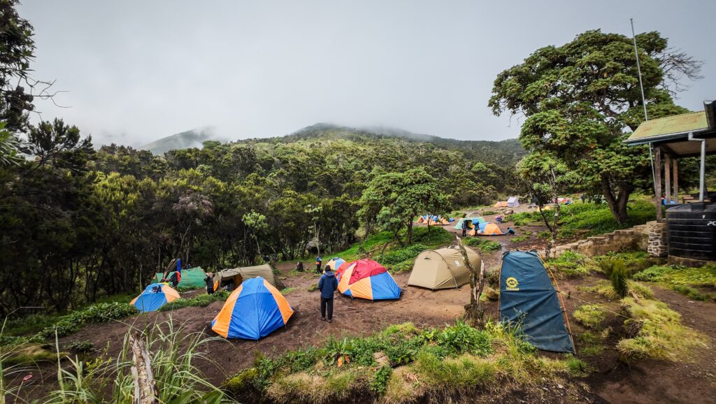
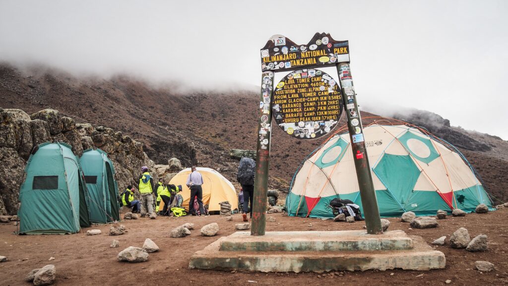
Marangu Route (5–6 days)
Often called the “Coca-Cola” route, this is the only path with hut accommodations instead of tents. It’s the shortest and has a steady, direct trail, but that also means less time to adjust to the altitude, making it one of the routes with a lower success rate.
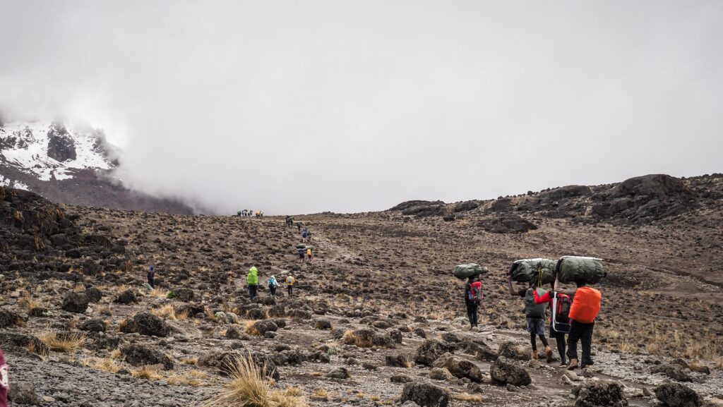
Pros: Comfortable huts, easier logistics
Cons: More crowded, limited scenery variety (same trail up and down)
Machame Route (6–7 days)
Known as the “Whiskey” route, it’s one of the most popular choices. The trail is more scenic and diverse than Marangu, passing through rainforest, moorland, and alpine desert. It allows better acclimatisation with its “climb high, sleep low” profile.
That route was the one that I chose, and I decided on a 6-day itinerary. If I had to do it again, I would definitely go for a 7-day version to give myself more time for acclimatisation and avoid potential problems on the summit day. However, the ability to acclimatise is always individual.
Pros: Stunning views, good acclimatisation (I would choose the 7-day variant)
Cons: Steeper and more physically demanding
Lemosho Route (7–8 days)
This is considered one of the best all-around routes, offering a scenic, less crowded approach with a higher success rate due to its longer acclimatisation period. It begins on the western side of the mountain and merges with the Machame Route later on.
Pros: Excellent acclimatisation, remote and scenic start
Cons: Slightly more expensive due to longer duration
Rongai Route (6–7 days)
Approaching from the north near the Kenyan border, this trail is drier and offers a quieter, less-travelled path. It’s great during the rainy season since it’s on the mountain’s more sheltered side.
Pros: Less crowded, good for wet-season climbs
Cons: Less dramatic scenery compared to western routes
Northern Circuit (8–9 days)
This is the longest route, circling the mountain’s northern slopes. Its extended duration offers the best chance for acclimatisation and solitude.
Pros: Highest success rate, remote and uncrowded
Cons: Longest and often most expensive
Umbwe Route (5–6 days)
A steep and direct route is best suited for experienced trekkers. It’s not recommended for most climbers due to the fast ascent and poor acclimatisation profile.
Pros: Challenging and quiet
Cons: Low success rate due to rapid altitude gain
The view of Mount Meru
Which agency to choose?
Climbing Mount Kilimanjaro requires you to go with a licensed tour operator, and you must be accompanied by a certified guide. This is a regulation enforced by the Tanzanian government to ensure climber safety and environmental protection. Solo, unguided treks are not allowed.
Guides are trained in recognising altitude sickness, emergency procedures, and route logistics. Along with guides, most treks include porters, who carry gear and supplies, and a cook, who prepares meals on the mountain. This team makes the climb more manageable and increases your chances of reaching the summit.
Choose a company that is officially registered with the Kilimanjaro National Park authorities and follows local labour and safety laws. Check if the porter will carry a portable oxygen cylinder in case you get into trouble.
Look for companies that employ certified guides with strong knowledge of first aid, altitude safety, and good reviews from past climbers.
Support companies that are part of or recognised by organisations like KPAP (Kilimanjaro Porters Assistance Project), which ensures fair wages and treatment for porters.
Beware of ultra-cheap tours as these often cut corners on safety, food, or porter welfare. A mid-range to premium tour might cost more, but it usually includes better equipment, safer practices, and better success rates.
Read recent reviews, paying attention to how the company handles altitude sickness, emergencies, and client care. Look for companies with a high summit success rate and clear emergency protocols.
After quite a long research, I decided to climb Kilimanjaro as well as do a 6-day safari with Kilinge Adventures, which is based in Moshi. The contact with Thomas (the owner) on WhatsApp was very easy, and once I arrived in Moshi, he, together with the guide, came over to my accommodation for a briefing.
I paid 1400 USD for a 6-day variant of the Machame Route. Overall, the service provided was good, and I reached the summit, although on the summit day, I suffered due to altitude sickness, and I had the feeling that more could have been done to monitor my health. For example, the guide was not equipped with a device to check my pulse rate and level of oxygen, which I saw that other guides were doing with their clients.
Costs of climbing Kilimanjaro
Climbing Mount Kilimanjaro is a serious adventure, and it comes with a price tag to match. The total cost can vary widely, depending on the route, tour operator, number of days, and the level of service you choose.
Typical price range (per person):
Budget climb: $1,500 – $2,000
Mid-range climb: $2,000 – $3,500
High-end climb: $3,500 – $6,000+
Here’s what you’re paying for:
Park fees (a big chunk—$800+ per person for a 6–7 day trek)
Guide, porter, and cook wages
Camping equipment or hut accommodation
Food, water, and logistics on the mountain
Transport to and from the trailhead
Cheaper trips often mean fewer meals, overloaded porters, or less experienced guides, so it’s smart to strike a balance between affordability and reliability.
Tipping culture
Tipping is expected and considered a standard part of the climb. Your guide and support crew work hard, often in tough conditions, to help you reach the summit safely and comfortably. Tips are a major part of their income. The best is the ask your agency and make it clear what is expected, but also don’t let it discourage you from climbing.
To be honest, I didn’t give as high tip as was expected from me, but I clearly stated that this is the maximum that I can calculate into my budget, so it was either that or nothing.
Typical tipping breakdown (per group, per day):
Lead guide: $20–30
Assistant guide: $15–25
Cook: $10–15
Porter: $5–10 each
For a 7-day trek, a group of 2–4 people might tip anywhere from 300 to 500 USD per climber in total.
Tips are usually pooled and distributed on the last day, often during a ceremony. In my case, I handed over the amount to my lead guide and sent him the message on WhatsApp on how to distribute it between team members. It doesn’t matter if you give dollars or simply withdraw local currency from an ATM.
Additional costs
When budgeting for Kilimanjaro, don’t forget to factor in:
Flights
Travel insurance (must include high-altitude trekking)
Gear rental or purchase
Medications
Visa fees and pre-/post-climb accommodations
The experience is a big investment, but for many, it’s a once-in-a-lifetime journey that’s well worth the cost. From the perspective of time, I can definitely say that I don’t regret it!
The best time to climb
The best time to climb Mount Kilimanjaro is during its two dry seasons, when the weather is generally more stable and visibility is at its best. These periods fall between January to mid-March and June to October.
The January to March window tends to be a bit quieter on the trails, with fewer climbers and cooler temperatures at the summit. It’s a great time for those seeking solitude and crisp, clear mornings, though occasional afternoon snow can fall at higher elevations.
The June to October season is the most popular due to its dry conditions and warmer days, especially during the mid-year holidays. Skies are usually clear, offering spectacular views, but this also means more people on the mountain.
Avoid the long rainy season (March to May) and the short rainy season (November) if possible, as trails can become slippery, clouds may block the views, and summit attempts are more challenging in wet conditions.
What to pack?
Packing smartly for a Kilimanjaro climb is key to staying comfortable, safe, and successful on your journey. Since you’ll be trekking through several climate zones, from humid rainforest to arctic-like summit conditions, you’ll need to be prepared for a wide range of weather.
All necessary equipment can be rented in Moshi, although I would recommend taking your own sleeping bag, which you trust, as there is nothing worse than being cold in the night. The weather is very changeable, and most likely you will get wet. Always keep another set of dry clothes in a waterproof place. If your things get wet, it may not be easy to dry them along the way.
I rented a few things from Gilmans Outdoor Store, and the quality was excellent.
Clothing
Base layers:
Moisture-wicking thermal tops and bottoms (to keep sweat off your skin)
Breathable underwear and hiking socks
Mid layers:
Fleece or insulated jacket for warmth
Long-sleeve shirts and trekking pants
Outer layers:
Waterproof jacket and pants (Gore-Tex or similar)
Down or synthetic puffy jacket for summit night
Accessories:
Warm hat and sun hat
Gloves: one lightweight pair and one insulated, waterproof pair
Neck gaiter or buff for wind and dust
Sunglasses with UV protection
Footwear
Sturdy, broken-in hiking boots (waterproof)
Comfortable camp shoes or sandals
Gear
A durable backpack (30–40L) for your daily essentials
A large duffel bag or backpack (porters will carry this)
Sleeping bag (rated for cold temperatures, at least -10°C)
Trekking poles (helpful for balance and reducing strain)
Headlamp with extra batteries (essential for summit night)
Water bottles and/or hydration bladder (minimum 3L capacity)
Dry bags or plastic zip bags (to protect electronics and clothing from moisture)
Toiletries & Health
Sunscreen and lip balm with SPF
Wet wipes and hand sanitiser
Toothbrush, toothpaste, and biodegradable soap
Personal medications, altitude sickness meds (consult your doctor)
First aid essentials: blister pads, band-aids, painkillers, etc.
Fingertip pulse oximeter
Others
Power bank for charging devices
Snacks or energy bars for an extra boost
Lightweight towel
Travel journal or book for downtime
Small binoculars or a camera
How to get to Moshi?
By Air
The nearest airport is Kilimanjaro International Airport (JRO), located about 40 km from Moshi. It serves international and domestic flights.
Taxi/Private Transfer from the airport to town takes 45 minutes and costs about $30-$50. Alternatively, some hotels and tour companies offer shared transfers (~$10-$20) or just take a local tuk-tuk and negotiate the price.
You can also fly into Julius Nyerere International Airport (DAR) in Dar es Salaam or Abeid Amani Karume Airport (ZNZ) in Zanzibar and take a domestic flight to JRO or Arusha.
By Road
From Arusha (80 km, 1.5-2 hours) – Buses, shared taxis, and private transfers run frequently.
From Dar es Salaam (500 km, 8-10 hours) – Luxury buses like Kilimanjaro Express or Dar Express offer comfortable rides for 15-20 USD.
From Nairobi, Kenya (350 km, 6-7 hours) – Shuttle services run daily, costing about 30 USD. Border crossing at Namanga is required.
By Train
Tanzania’s rail network is limited, but there is a train from Dar es Salaam to Moshi (though infrequent and slow). Buses are a better option.
Where to stay in Moshi?
I recommend Karibu Africa House and The Better Inn. Both places offer good quality at an affordable price, and they also offer day trips to Lake Chala or Marangu, but Karibu Africa House is significantly cheaper in that aspect.
My experience on the 6-day Machame Route
Day 0: Briefing in Moshi
Organisational day. First, I stopped at Gilmans Outdoor Store to rent some stuff for the hike: fleece, rain jacket, hiking poles, gloves and a day backpack. The quality of the items was really good, although the price wasn’t. If you don’t mind paying, you can get everything you need in Moshi, but in general, I would recommend taking your own equipment.
Then, I went to the supermarket to buy some snacks, chocolate and energy bars. Not too many, as it was clearly communicated that all meals are included in the price of the hike and there will be a cook preparing them daily.
When I came back to my accommodation, the landlady knocked on my door and informed me that my guide had arrived. It was Thomas (the owner of the Kilinge Adventures) and my mountain guide, Tayson. He came into my room to check the equipment and recommended renting one more warm jacket (which later on proved to be a good decision, even though at first I was sceptical about it).
I finished packing my backpack and was waiting in excitement for the next day!
Day 1: Machame Gate to Machame Camp (10,3 km, 1218 m up)
I had breakfast at my accommodation and was then picked up by the guide with only a small delay. Nice surprise considering that the services in Tanzania aren’t exactly punctual! We stopped at one more location to rent a rain poncho and two plastic bottles. The prices they have in Moshi are simply ridiculous. You can buy your own poncho and water bottles for the same price or even cheaper in Europe than renting them for a few days here. But well, they are taking all the advantage they can from having Kilimanjaro.
Then, we set off to Machame Gate. Once we arrived, it took forever to handle all the paperwork. I got my lunchbox even though I was not hungry at all, as it was too early. One of the monkeys stole my yoghurt, but maybe it was for the better… Better not to take any risks before such a long hike!
Finally, Tayson asked me to sign some papers, and it gave me the hope that we were about to start the real hike… but nope. I was slowly getting more and more annoyed, and probably after another 45 minutes of waiting, we went through the security gate and entered the forest. The security gate was a real deal, and they even asked me to open my backpack to see if I was carrying a drone or other prohibited items.
The first section to Machame camp was led through a scenic mossy forest, and it reminded me of the area at Mount Taranaki in New Zealand. Unfortunately, it started raining, and I had to wear my poncho for the first time.
The beginning of the hike
When we arrived at the camp, it was foggy, wet and cold. Not exactly how I was imagining the first 2-3 days of the hike. I thought it would be rather warm and pleasant, especially at lower elevations! I had to wait a bit for my tent to be ready, but then I was quite impressed. There was one section for sleeping and another one with a table and a chair for eating meals and relaxing. Pretty cool!
Machame CampThe first meal
The first dinner was yummy, and our cook served fried potatoes with fried fish. I was also given a big bottle of hot water and could choose any drink I wanted: tea, cocoa, coffee, etc.
Apparently, I was added to the group of 10 other hikers, but it was only theoretical as I didn’t have any interaction with them for most of the time. I didn’t bother too much as I wanted to enjoy my experience in nature rather than forcing myself to socialise with much older folks who were probably from the UK or the US.
The first night was okayish, but I started taking preventive medication for altitude sickness, so I had to get out of the sleeping bag to pee quite frequently.
Day 2: Machame Camp to Shira Cave (4,8 km, 863 m up, 40 m down)
Easy day. The weather in the morning was good, and there were nice views of Mount Meru in the distance. The path was climbing up steadily, and it was not too challenging. The last section was more rocky, but still, nothing serious.
We arrived at the camp very early. I was walking around, but every now and then, the clouds were rolling in, so the conditions weren’t optimal for hanging out outside. At sunset, it improved a bit, and the clouds cleared. I could see the snowy summit of Kilimanjaro in the distance.
Today I realised that the portable toilets that were set near my tent were not for common use but for the rest of my group, as they paid extra for them. LOL. Good to know that I took a shit there twice the day before, and oh damn, it was a smelly one. What do people have in their minds that they pay extra for portable toilets, and they actually hire an extra porter to carry one? The public ones are just fine. I mean, it is just a stinky hole in the ground, but what would you expect on the mountain?
The way to Shira Cave CampShira Cave CampShira Cave CampSunset at the Shira Cave Camp
Day 3: Shira Cave to Barranco Camp (9,7 km, 806 m up, 667 m down)
Beautiful hike, although again the weather was difficult. The first section of the Lava Tower had amazing views of the mountain at all times. Kilimanjaro looked pretty wide from that perspective, and there was a lot of snow near its top.
While we were approaching the Lava Tower, the weather was getting worse. It seems to be a standard on that mountain after noon. Luckily, instead of waiting for lunch, we just decided to make a short stop for snacks and then continued the way towards Barranco Camp.
Kilimanjaro seen at sunrise
I had some stomach problems that started the previous night, and I suspected that the vegetables served for dinner were to blame. It made me feel uncomfortable, and I had to make unwanted stops. I decided to start taking antibiotics, even though I knew that they could harm my body during the upcoming summit push.
Then, it started raining, which was a pity as the way down to the camp was very scenic, full of unique trees that I could see so many times in the pictures and brochures about Kilimanjaro. Those are giant groundsel that are often mistaken for palm trees due to their unusual appearance. These plants, scientifically known as Dendrosenecio kilimanjari, have thick, weathered stems topped with large, succulent rosettes, resembling a cross between a Joshua tree and a pineapple.
Porters carrying bags on their headsHeading to the Lava Tower CampThe Lava Tower CampWalking among giant groundsel
Once we arrived at the camp, I registered in the book and waited for a while for the tent to be set up. Then, I jumped inside and changed all my clothes to dry ones. The cook surprised me with freshly made popcorn, which I enjoyed sitting on the chair in front of the tent with an American girl of Vietnamese origin whom I had met the day before. This was also the place where we had our dinner. This time I decided not to touch the vegetables!
Day 4: Barranco Camp to Barafu Camp (7,8 km, 965 m up, 305 m down)
The day when the problems started.
The first part of the hike was relatively good. We arrived at Karanga Camp after climbing the steep Barranco Wall. In Karanga, it was foggy, and I started feeling so-so, but I made a stop for snacks. Then, we started climbing higher and higher, and I was feeling worse and worse. The altitude sickness symptoms kicked in, and once I finally made it to Barafu Camp, I was completely exhausted.
I went inside the tent and waited there throughout the very bad weather, while it was even snowing! Then, the cook served me dinner, but I didn’t have any appetite, and I was forcing myself to eat anything. Even going out of the tent to pee seemed to be too tiring for me. I knew what was going on as I experienced altitude problems in Nepal a year ago. I reported the situation to Tyson, and he said that I had to try to sleep and we would evaluate the situation before leaving the camp for the summit push, so around 1 AM. Unfortunately, I wasn’t able to sleep at all.
If it had been my choice, instead of going to the summit, I would have gone back to Barranco Camp for one more acclimatisation day and only then pushed further to the summit. But if you climb Kilimanjaro, you have to decide how many days you want to do it; therefore, any flexibility is gone. You can either climb it in the given window or give up. No space for plan adjustments.
Hiking towards Barafu Camp
Day 5: Barafu Camp to Uhuru Peak to Mweka Camp (16,1 km, 1251 m up, 2802 m down)
Besides drinking something warm in the morning, I didn’t eat anything more than some biscuits. We set off at 1 AM, and I was going slowly. I had to stop many times to catch my breath. It was pitch black, so I could only see the lights of people who were some meters ahead of me. Unfortunately, I also saw some people going back as they also couldn’t continue due to similar problems to mine. But I was fighting, even though I knew I was taking a risk. If it had been a solo trip, I would have certainly walked down a bit to acclimate better. Such an option isn’t really an option on a guided hike like that one, though. At sunrise, instead of being at the summit as it was planned, I was not even at Stella Point, which is a major milestone at 5,756 meters. The point was named after Estella Latham, the first woman to ever reach this mark in 1925.
Tyson was checking on me very often, and at some point, he suggested that it’s time to turn back. The mountain would still be there, and pushing myself to the limits was too risky. I knew he was right, but I am stubborn by nature and didn’t want to give up just yet. The oxygen level was very low, and we made a break at Stella Point to have snacks and drink glucose.
My guide was very strict, and he told me that I had to descend. But there we were, 20 minutes walk from the summit. I could see it. I had so many thoughts in my mind, and I really didn’t know what to do, but I told Tyson that I was taking all responsibility for my actions and I would continue walking to the summit. He wasn’t happy at all!
I was walking slowly, even though the elevation gain was very little compared to what we did the night before. The views all around were truly breathtaking, and I could see the crater on the right and the leftovers of the glacier on the left.
Finally, I reached the summit. I didn’t even have the energy to celebrate. After taking a few pictures, I started something that I should have done a long time ago – descent to Barafu Camp.
Sunrise near Stella PointWalking the last meters to the summitMount KilimanjaroUhuru PeakMount KilimanjaroStella PointThe slopes of Mount Kilimanjaro
My legs were incredibly weak, and I almost fell down a few times. Due to a low level of oxygen in my body, I felt like I had been drinking a few beers, and I was dizzy. We passed Stella Point and then took a shortcut down, which was incredibly difficult as it was steep and full of loose stones. I fell down once or twice, and I was incredibly sleepy. During breaks, I had the feeling that I had to give up, and I would not be able to make more steps without some rest and sleep. Tayson kept motivating me, and luckily, it worked.
We made it to the camp, and I immediately jumped into my tent, lay down and fell asleep. The cook brought me food, but I wasn’t able to eat anything. Apparently, I asked Tyson if I could get a moto-taxi down to another camp. LOL. It only proved how destroyed and delusional I was because I had no idea how I could ask this kind of stupid question. There was no common sense in my way of thinking. I had the feeling that I had a fever, but it was probably just a sunburn on my face, as in all that mess, I had forgotten to apply sun cream.
I found leftovers of strength, or maybe I just didn’t have another option, and left the tent for over 2 hours of walking down to Mweka Camp. Luckily, I was feeling a bit better and the whole way the trail was descending. We arrived when it was already dark, and I only ate a little bit of dinner before I dropped off to sleep.
Damn, what a day it was.
Day 6: Mweka Camp to Mweka (9,5 km, 1549 m down)
From Mweka Camp, it was about 2-3 hours to the gate, and I made it quite quickly. I took a last picture with a goodbye sign, and I finally met with Ni, the American / Vietnamese girl whom I had hung out with in previous camps. She knew everything about my situation from other guides, as it seems the news spread fast on the Kilimanjaro slopes 🙂 She was fast and made it to the summit when it was still dark, without any problems.
She invited me to join her for the trip to the hot springs the next day, and I probably would have gone, but Thomas signed me up for the safari starting the next day, and it was not possible to delay it, as I was joining a group.
We stopped at Gilmans to return the rental equipment, and then I went to the hotel. I gave Tyson a tip with a detailed split of the amount per other members of our group, including porters and the cook.
Then I did my laundry as I had to quickly repack for the safari trip, and ate a delicious pizza in Blossoms Cafe. In the evening, I met up for dinner with Ni, and we exchanged our experiences from the roof of Africa over Thai curries 🙂
Summary
Overall, it was a great hike, but also the most challenging one for me so far. I think there were several reasons why I suffered, and if I had had to do it again, I would have played it differently.
Firstly, I wasn’t in the best shape. Before coming to Moshi, I spent a few days in the Usambara Mountains, where I got some serious infections. On top of stomach problems and fever, I also had a cough which I could not get rid of, and I was struggling with it for the whole time on Kilimanjaro. I started the hike straight after taking medicine for a few days, including antibiotics. The symptoms of stomach issues came back on day 3, and I had to resume taking antibiotics as a precaution. My organism was surely not at 100%.
Secondly, I was taking Acetazolamide as a prevention for mountain sickness, but still got plenty of symptoms of it. Who knows what would have happened if I hadn’t taken that medicine? Quite likely, I would have been taken off the mountain by a helicopter. Hopefully not in a plastic bag. Acute altitude sickness should not be ignored; however, when people pay so much money, they want to make it to the summit no matter what. Flexibility is crucial here. If hiking solo, I would have done one more acclimatisation day before the summit push. So maybe it’s a smart idea to discuss this with the travel agency if such an option exists, in case you notice that you need it. If not, it’s worth considering taking longer Lemosho or Northern Circuit routes.
Regardless of all problems, I came back from Kilimanjaro with priceless memories and new experiences in high-altitude hiking. Many people say that it is once in a lifetime experience, but in fact, I would like to set foot on the roof of Africa once more in the future!
The Usambara Mountains in northeastern Tanzania are a range known for their dramatic landscapes, rich biodiversity, and cultural heritage. They form part of the Eastern Arc Mountains, a chain of ancient, forested highlands stretching across East Africa. Due to the number of species found nowhere else, these mountains are considered one of the most important areas for biodiversity on the continent.
The Usambara Mountains lie roughly midway between Mount Kilimanjaro and the Indian Ocean, and they are divided into two main sections:
West Usambara Mountains – centred around the town of Lushoto, known for its cooler climate and terraced agriculture.
East Usambara Mountains – home to more intact rainforests and protected areas like the Amani Nature Reserve.
The mountains rise sharply from the plains, creating valleys, cliffs, and fertile hillsides that support both forest and farming communities. The forests are estimated to be tens of millions of years old, which makes them hotspots for unique plant and animal life. You will find rare birds like the Usambara eagle-owl and greenbul, unique reptiles such as two-horned chameleons and countless butterflies, orchids, and medicinal plants.
The Wasambaa people have lived in the region for generations. They’ve developed sustainable farming techniques suited to the steep terrain, including terracing and intercropping. Agriculture is central to life here, with bananas, maize, potatoes, and vegetables being commonly grown.
The history of Lushoto
Lushoto has long served as a retreat from the heat of the lowlands and a cultural hub for the surrounding region. Its history is closely tied to both local traditions and colonial developments that left a lasting impact.
In the late 1800s, German colonists arrived in the region, and Lushoto became part of German East Africa. Attracted by the cool climate and fertile soil, the Germans saw the area as ideal for settling. They renamed the town Wilhelmstal in honour of the German emperor.
During this time, European-style buildings, schools, and mission stations were constructed. The Germans introduced new crops, roads, and administrative systems. They also converted parts of the surrounding forest into agricultural estates, experimenting with crops like tea and coffee. Some of the architecture from this period still stands today, giving Lushoto a unique blend of African and European character.
After World War I, Germany lost control of its East African territories. The British took over, and the name Lushoto was restored. The British continued to use the area for agricultural research and as a cooler, more temperate highland post. Missionaries, educators, and colonial administrators helped expand schools and clinics, many of which served both colonial and local populations.
Even after Tanzania gained independence in 1961, Lushoto retained its role as a regional centre for education, farming, and governance. The surrounding hills became more populated, and the town began to grow gradually, though still relatively quiet and rural.
Today, visitors come to hike through mountain trails, explore forests, visit waterfalls, and meet local families who preserve traditional farming and herbal practices.
How to get there?
By Bus
From Dar es Salaam
Take a long-distance bus heading toward Moshi, Arusha, or Lushoto directly (some companies offer this). Get off at Mombo, the junction town at the base of the mountains. From Mombo, take a local daladala (minibus) or shared taxi up the winding road to Lushoto (~1 hour). The road is paved but steep and curvy.
From Tanga
Tanga has minivans and buses that connect to Mombo or Lushoto directly. The road is in fair condition and passes through rural villages and farmland.
From Arusha or Moshi
Travel south by bus along the main highway toward Moshi, Himo, then on to Mombo. From Mombo, transfer as above to Lushoto.
By Air
There is no airport in Lushoto itself. You can fly into Tanga Airport (from Dar or Zanzibar), then travel by road to Lushoto. Alternatively, fly to Kilimanjaro International Airport (JRO) or Arusha, then take a bus or private transfer south to Mombo/Lushoto.
By Car or Taxi
Hiring a private car from Moshi, Tanga, or Dar es Salaam gives you more flexibility and comfort, especially if travelling in a group. A 4×4 isn’t usually necessary unless you’re continuing to remote areas like Mambo Viewpoint or during the rainy season.
The best time to visit
June to October: This is the cooler, dry season and is considered ideal for hiking, village tours, and nature walks. The skies are clearer, and the risk of heavy rain disrupting outdoor activities is low.
December to February: Also relatively dry and slightly warmer, but still a good time for travel and sightseeing.
Lushoto’s elevation (over 1,400 meters) means it enjoys a cool, temperate climate year-round, especially compared to the coastal or lowland areas.
Even in the dry season, mornings and evenings can be chilly, so it’s wise to bring a warm layer, especially if you’re heading to higher areas like Mambo Viewpoint or Magamba Forest.
Where to stay?
I stayed in the Steven and Dayness Homestay, located within walking distance of the Lushoto town centre. The room was really spacious and could accommodate even 4 people. They also organised a hiking guide for the Lushoto – Mambo route and stored my luggage.
Hiking from Lushoto to Mambo
The Lushoto to Mambo or Mtae hiking route is one of the most scenic and culturally rich treks in the Usambara Mountains. It takes you across forest trails, hillside farms, local villages, and breathtaking viewpoints. The standard itinerary takes about 3 days but can be modified according to your expectations.
I did it with the guide and strongly recommend that you do the same. While it is possible to follow offline maps (e.g. Mapy.CZ) and do it independently without any significant dangers or risk of getting lost, I felt I really learnt a lot from my guide, and he was a great and very open person to talk to.
Rashid can be contacted on WhatsApp: +255 623 278 325 or on Instagram: @lushoto_adventures.
How much does it cost?
I handled all the organisation through my guesthouse, and you should expect to pay between 45-50 USD per day per person. The price includes a guide, accommodation and food.
Day 0
In the evening, my guide Rashid came over to the place where I was staying to introduce himself and share some more details about the hike and the route. He seemed to be a very nice guy, so I was sure that I was going to be in good hands!
Day 1
Route: Lushoto to Lukozi
Distance: ~ 20-22 km
We left Lushoto at about 8 AM, following a steady uphill trail into Magamba Rainforest, a protected area full of ancient trees, colobus monkeys, and birdlife. The temperature was pleasant and I quickly I got involved in the conversation with Rashid, while heading towards Magamba Village.
The surrounding was a combination of forest and farm fields, and we managed to spot some chameleons! Rashid had really good eyes for that, and I was sure that I wouldn’t see any of them if hiking alone. People that we met en route were very friendly, and they were always saying hello or waving to us. Very good picture opportunities, although sometimes I felt quite shy to point the camera at random people. Luckily, in many situations, they asked to take a photo of them! The people in that region mostly grow fruits and vegetables, and the whole area reminded me of the outskirts of Dalat in Vietnam.
The beginning of the hikeFirst chameleon spotted en route
After we passed Magamba Village, there was the section following the dust road, which was quite boring and tiring as it was getting hotter, but then we made a break and had lunch. It was delivered on a motorbike by the lady from my homestay. I was surprised, as we could have just packed it into our backpacks directly in Lushoto without troubling her 🙂
Then, we passed some more villages and fields, which was a great opportunity to observe locals during their daily activities: farming, carrying water, or simply spending time with each other.
When we were approaching our accommodation, there was one more serious uphill section, but we were rushing as the thunderstorm was coming. The place was called Bush Baby, and I was allocated to the big room with 3 different tents inside. All of them were not in the best shape and ripped in place, but the night was quite comfortable. There were also hot showers, and they had surprisingly good water pressure. In the evening, we had the chance to socialise with other tourists while having dinner.
Farm fieldsFarm fields
Day 2
Route: Hike from Lukozi to Rangwi, motorbike ride from Rangwi to Mambo
Distance: ~ 15 km (hike only)
The breakfast was really good, and it consisted of pancakes, jam, bananas, peanut butter, etc. Pretty standard for Tanzania, but really filling. Then, we hit the road, and the first section was going uphill for quite a while. The views were beautiful and we were surrounded by green hills. We met some friendly boys carrying buckets of water on their heads, and they were very pleased to be photographed.
Once we reached a kind of mountain pass, the route started to descend, going through very picturesque rolling hills, and once again I felt like in Asia. Finally, we arrived at Rangwi Convent, where we had lunch: noodles, rice, meat, beans, etc. Food definitely isn’t the strong side of Tanzania.
Some people decide to spend the night at a convent guesthouse or a basic homestay in a nearby village like Sunga. If you want to take a hike at a more leisurely pace, it will be a great option.
In my case, Rashid said that the hike between Rangwi and Mambo isn’t that nice, therefore it’s better to save the legs and cover the distance on the bikes. I agreed and soon we got picked by two riders and they took us to accommodation in Mambo village: Magumba Hotel. Before we arrived there, we made a stop at a local workshop where people make wooden cups, plates, and all that. From there, we walked the remaining distance to Magumba. The accommodation was beautifully located, and inside the room, there were 3 big beds and a lot of windows with a super cool panoramic view.
I got an idea to have an extra walk to Mambo Viewpoint, and it was enthusiastically accepted by Rashid. The walk there was quite pleasant, through a very lively village with lots of photo opportunities. The viewpoint is basically at the end of the Usambara Mountains with Mkomazi National Park at our feet, and we could see large plains spreading till the horizon. It was a great decision to come here and definitely a highlight of the day! We were greeted by 3 boys who were playing around, climbing trees. What a playground they have!
We spent quite a long time there waiting for sunset, and when it got a bit chilly, we decided to walk back. The dinner was classic but tasty: chicken, rice, beans. Luckily, I managed to get a hot shower even though the electricity wasn’t very stable, and it was on and off.
The view from Mambo ViewpointRolling hills
Day 3
We had to wake up very early to take a minibus back to Lushoto. At 5 AM, we were ready to leave, and we had to walk a bit to the ‘bus stop’. It was pitch black and quite chilly. The ride was incredibly bumpy, but I managed to sleep a little bit. The views outside had to be nice, but the windows in the bus were darkened and dirty, so it was really difficult to enjoy the ride.
Once in Lushoto, we went to breakfast and then hiked to Irente Viewpoint, Java Viewpoint and Kisasa Waterfalls, which I will describe in a separate paragraph below.
Other attractions around Lushoto
Irente Viewpoint
A dramatic cliff-top lookout point situated about 5 km west of Lushoto. From this viewpoint, you can enjoy breathtaking panoramic views of the Mazinde plains, the Pare Mountains and sometimes even Mount Kilimanjaro on a clear day. Hiking from Lushoto takes about 1.5 to 2 hours through scenic countryside and local villages. You can also get there on a motorbike.
Java Viewpoint
Another fantastic spot, very close to the much more popular Irente. In my opinion, it has even better views and is less crowded.
The view from Java Viewpoint
Kisasa Waterfall
Kisasa Waterfall is a moderate-sized waterfall nestled within a green forested valley. It is reached via a short hike through farmlands, forests, and sometimes steep, slippery trails.
Kisasa Waterfall
Other hikes
An alternative hike in that area takes you from Lushoto to Mazumbai Rainforest and takes about 2-3 days. Inquire about that option in your guesthouse or directly with Rashid (+255 623 278 325).
Tanga is a coastal city in northeastern Tanzania, located along the Indian Ocean. It’s one of the oldest and historically significant urban centres in the country. It has long served as a port city and regional hub due to its strategic position near the border with Kenya and along important maritime routes.
Historical Background
Before colonial times, Tanga was part of the broader Swahili Coast culture, characterised by a network of trading cities that engaged in commerce across the Indian Ocean. These communities traded with Arabian, Persian, and Indian merchants, exchanging local products like ivory, spices, and slaves for goods such as textiles and beads. Tanga’s population was largely influenced by foreign cultures, which is still visible in the city’s architecture and traditions.
In the late 19th century, Tanga became one of the first towns in mainland Tanzania to fall under German colonial rule. The Germans designated Tanga as an administrative and commercial centre, and they invested in infrastructure such as railways, roads, and port facilities. One of their most lasting contributions was the construction of the Usambara Railway, which connected Tanga to the interior of the country, facilitating the transport of agricultural products and other goods.
Tanga gained prominence as a key exporter of sisal, a plant used to make rope and other materials. The crop became the backbone of the local economy, and the region was known as the “Sisal Capital” of the world for a time.
Tanga is historically notable for being the site of the Battle of Tanga in 1914, one of the first major battles in the East African campaign of World War I. British forces attempted to capture the town from the Germans but were defeated in a well-documented and embarrassing retreat, sometimes referred to as the “Battle of the Bees” due to swarms of bees disrupting the fighting.
After World War I, Tanga came under British administration. While the British continued to support sisal cultivation, the city’s economic growth slowed compared to other Tanzanian centers like Dar es Salaam. Following Tanzania’s independence in 1961, Tanga remained an important regional center but gradually lost some of its economic dominance as focus shifted elsewhere.
Today, Tanga continues to serve as a port and supports trade in agricultural products, including sisal, tea, and coffee. The city is also a gateway to natural attractions such as the Amboni Caves, the Usambara Mountains, and nearby beaches.
How to get there?
By Air
Tanga has a small domestic airport that serves flights mainly from Dar es Salaam, Zanzibar, and sometimes Arusha or Moshi. These flights are usually short (about 1 hour from Dar es Salaam) and are offered by local airlines.
By Road
From Dar es Salaam
The drive takes around 6–8 hours, depending on traffic and road conditions. The route is mostly paved and passes through towns like Chalinze and Segera.
From Arusha or Moshi
Travelling from the north takes a similar amount of time (6–8 hours) and offers scenic views, especially near the Usambara Mountains.
From Mombasa (Kenya)
Tanga is quite close to the Kenyan border, so it’s also possible to travel from Mombasa via the Horohoro border post. However, make sure to check visa requirements and border crossing procedures.
By Bus
Several long-distance bus companies operate routes between Tanga and other major Tanzanian cities like Dar es Salaam, Arusha, Moshi, and Dodoma. Buses are usually affordable and run daily, though the journey can be long and tiring. Booking in advance is recommended for comfort and reliability.
By Train
Historically, Tanga was connected by the Usambara Railway, linking it to Moshi and the interior regions. While the train services aren’t as active or reliable today for passenger transport, there are occasional efforts to revive or maintain the railway for cargo and limited travel.
By Sea
Tanga has a functioning port, and while it’s mainly used for cargo, there are sometimes ferry services or private boats between Tanga and Zanzibar. This option is less common for travellers but might be available for those seeking a more adventurous route.
One of the historic buildings in Tanga
The best time to visit
Main Dry Season: June to October
This is considered the ideal time to visit. The weather is mostly sunny, with lower humidity and minimal rainfall. Temperatures are warm but comfortable, making it great for outdoor activities like visiting beaches, exploring the Amboni Caves, or hiking in the Usambara Mountains nearby.
Short Dry Period: January to February
This is another decent time to travel, especially if you want to avoid peak tourist season. Rain may occur occasionally, but it’s generally light and brief.
Fewer tourists visit Tanga compared to places like Zanzibar or Arusha, so even in the best season, it’s usually not crowded. Mosquitoes and the risk of malaria tend to increase during the rainy seasons, so visiting during the dry months can also reduce health risks.
Where to stay?
I stayed in the Nyinda Executive Hotel, located within walking distance of the city centre. The room was simple, but for one night, it was more than enough. They also have a restaurant.
What to see in Tanga?
All the interesting sights are located within walking distance, and you won’t need more than half a day to see them.
Start at St. Augustine Anglican Church, and then continue to St. Anthony’s Cathedral. It is the main Catholic church in the region and the seat of the local bishop. Built between 1893 and 1898 during the German colonial period, it stands as one of the oldest cathedrals in Tanzania.
Nearby, you can admire the building of Tanga City Hall as well as pay a visit to the URITHI Tanga Museum. Established in 1999 by the Tanga Heritage Centre (Urithi), a non-profit organisation, the museum is housed in a restored German colonial-era building. Visitors can explore a diverse collection of artefacts, photographs, and exhibits that narrate the story of Tanga’s evolution from its early days to the present. The museum is small, but it’s worth a visit. Tickets are 10.000 TSH for foreigners, including the guide.
The Tanga Library
Other historic buildings with nice architecture, which are the reminders of the past, are the Tanga Library, the Usambara Court House, the Old Tanga School and the Historic German Hospital. If you need a moment of break and rest, you can chill at Jamhuri Park, Uhuru Park, or Raskazone Beach. Inside Jamhuri Park, you will find the German Clock Tower, which was recently renovated. It was constructed originally in 1901.
Uhuru ParkThe German Clock Tower
What to see out of town?
Amboni Caves
One of the most extensive limestone cave systems in East Africa. Formed around 150 million years ago during the Jurassic period, these caves are a natural wonder shaped by ancient marine processes when the region was submerged under the ocean.
What makes the Amboni Caves particularly interesting isn’t just their geological formation, but also their cultural and historical significance. Over the years, they’ve served different roles: from places of refuge and worship to tourist attractions. Some local communities, especially those of the Segeju and Digo ethnic groups, consider the caves sacred and associate them with spiritual practices.
Inside the caves, you’ll find stalactites and stalagmites in various shapes. Exploring the caves requires a guide. The system has about ten caves, but only one is open to tourists.
Overall, if you have ever been to any caves, I don’t think you will find Amboni particularly interesting. The visit is short, and of course, they will charge you a mzungu entrance fee, which is 10 USD. You can easily come here on a boda-boda from Tanga centre, and you should ask the driver to wait for you.
Inside Amboni CavesBatsInside Amboni Caves
Tongoni Ruins
The remains of a once-thriving Swahili settlement are located about 17 kilometres south of Tanga, along the Tanzanian coast. These ruins are a reminder of the region’s rich maritime and Islamic history, dating back to the 14th or 15th century.
At its peak, Tongoni was an important fishing and trading town, likely involved in regional and international trade across the Indian Ocean. The site includes crumbling coral stone structures, old houses, mosques, and a notable collection of tombs. Some of these graves are believed to belong to local rulers and Islamic scholars, suggesting the settlement held both political and religious significance.
What stands out about Tongoni is its connection to the early spread of Islam on the East African coast, as well as its role in the larger Swahili culture that blended African, Arab, and Persian influences. The ruins reflect a time when coastal towns like this were centres of learning, commerce, and seafaring.