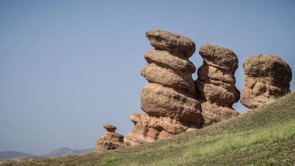
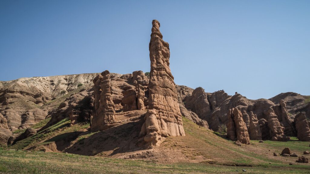
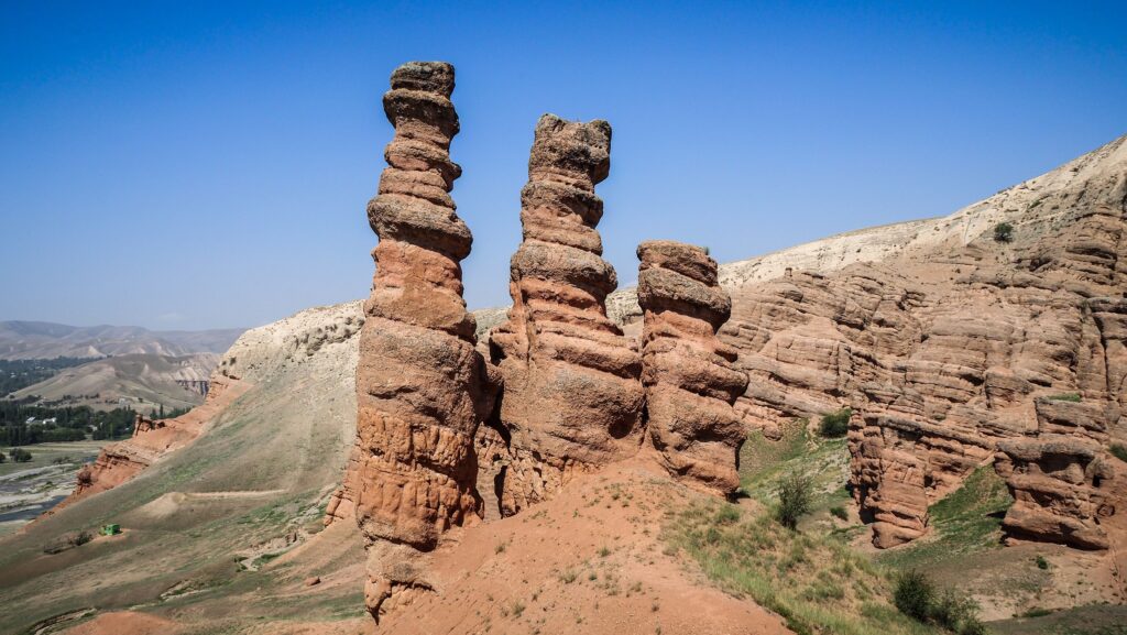
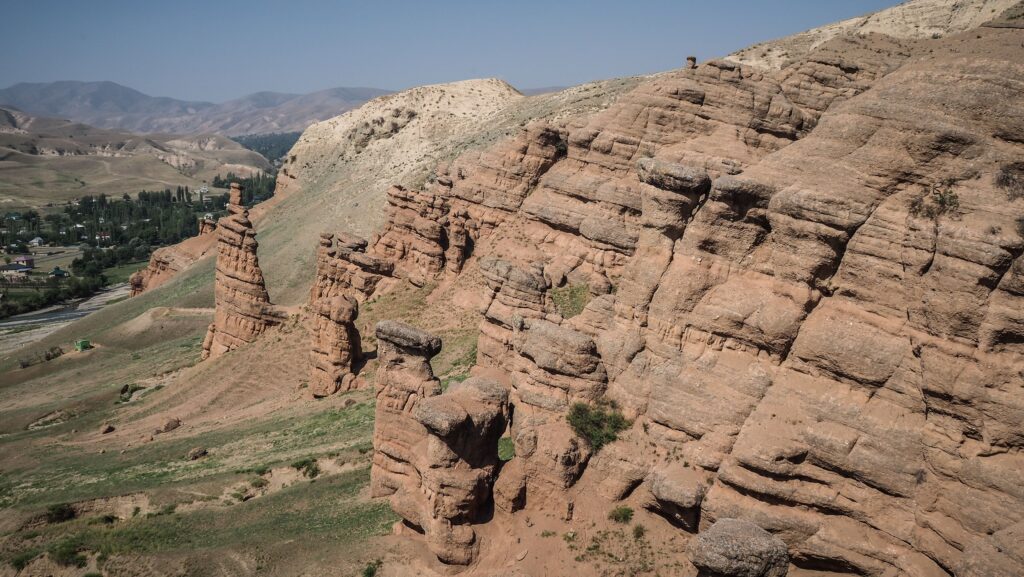
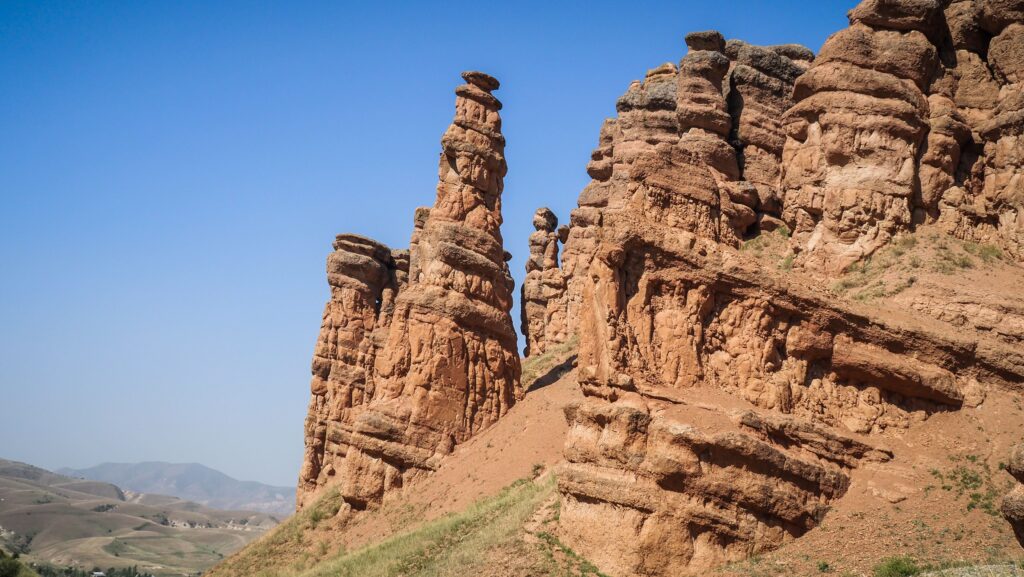
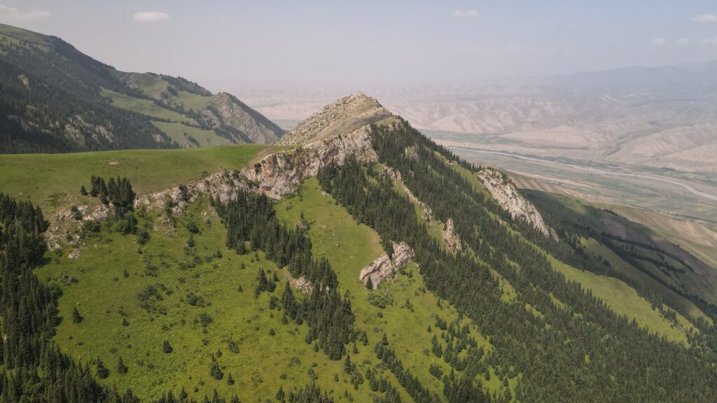
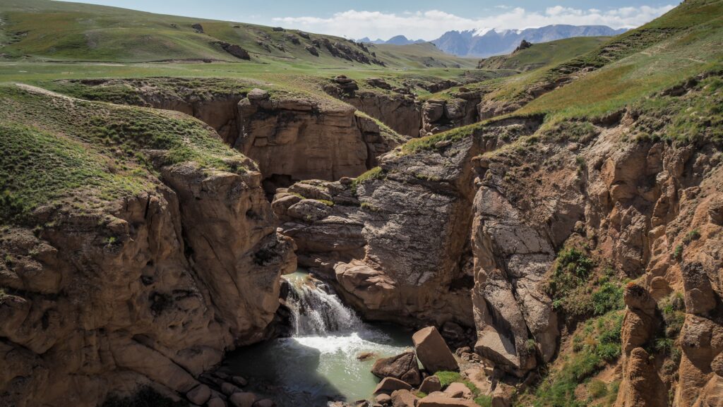
Most people travelling to Sary-Chelek are focused on reaching the famous alpine lake, often driving straight past one of the region’s most remarkable landscapes. Burana-Tash Canyon is an overlooked stop that deserves far more attention than it receives. Shaped over millions of years by natural erosion, this maze of sandstone cliffs, towers and narrow passages feels like a miniature desert hidden among the green valleys of western Kyrgyzstan.
Unlike the country’s dramatic alpine scenery, Burana-Tash offers a completely different experience. Instead of glaciers and snow-capped peaks, you’ll find soft sandstone formations rising above the Kara-Suu Valley, their rounded shapes sculpted by countless years of wind and seasonal rain. With almost no visitors and no tourist infrastructure, it remains one of those places where you can simply explore at your own pace and enjoy the silence.
How to get to Burana Tash Canyon?
Burana-Tash is located near the village of Syny, along the road connecting Tash-Kömür with the Sary-Chelek Biosphere Reserve. If you know where to look, the sandstone cliffs are easy to spot from the highway, standing out against the surrounding greenery. A rough dirt track leads towards the canyon, although it is not signposted, so many travellers pass by without realising such an impressive landscape lies just a short distance away.
Just after the village of Syny, you have to turn right and cross the bridge over the Kara-Suu River. Then, turn right again into a visible dirt road on Google Maps (satellite view) and follow it until the canyon. If driven slowly, the place should be possible to reach in any car.
How to explore Burana Tash Canyon?
The canyon itself stretches alongside the Kara-Suu River and consists of dozens of weathered rock formations separated by sandy gullies and dry streambeds. The sandstone is relatively soft, allowing wind and water to slowly carve unusual shapes into the rock. Some cliffs resemble castle walls, others look like giant pillars or natural sculptures, while narrow corridors invite visitors to wander deeper into the landscape.
One of the highlights of Burana-Tash is the freedom to explore. There are no designated trails, barriers or viewing platforms, so you can simply choose a direction and see where it leads. Short climbs reward you with panoramic views over the canyon and the surrounding valley, while the winding passages between the cliffs reveal new perspectives at every turn. Because the terrain is fairly compact, even a visit of an hour or two is enough to experience much of the area.
Photographers will especially appreciate the constantly changing colours of the sandstone. During the middle of the day, the cliffs appear pale yellow or cream, but as the sun lowers they take on warm shades of gold, orange and amber. Combined with the green vegetation along the river and the distant mountains, the contrast creates one of the most photogenic landscapes in this part of Kyrgyzstan.
You are unlikely to encounter crowds, and there are no cafés, souvenir shops or entrance gates to interrupt the natural setting. Bringing water, wearing sturdy shoes and allowing enough time to explore the various rock formations is all you really need.
If you’re driving to or from Sary-Chelek, Burana-Tash makes an excellent detour. It offers a striking change of scenery from the forests and lakes that dominate the region and showcases another side of Kyrgyzstan’s surprisingly diverse landscapes. For travellers who enjoy discovering places that remain largely off the tourist trail, this hidden sandstone canyon is well worth the stop.
Located in the central part of the country, Naryn is known for its mountains, wide-open landscapes, and strong nomadic traditions. While the town itself is fairly small, it’s an excellent base for exploring some of Kyrgyzstan’s best natural attractions, including Song-Kul Lake, Tash Rabat, Kel Suu Lake, Eki Naryn, Salkyn Tor, and several scenic mountain passes.
If you’re looking for luxury hotels or busy tourist streets, Naryn probably isn’t the right destination. But if you enjoy road trips, hiking, horseback riding, or simply spending time in nature, this region has plenty to offer. The slower pace of life and relatively small number of visitors make it feel much more authentic than some of the country’s better-known destinations.
Permits
There is a CBT office in town, so if you plan trips from Naryn to Kel Suu Lake or other places that require a permit, you can arrange them here.
How to get to Naryn?
The town is connected to the rest of the country by well-maintained roads, and several transport options are available depending on your budget and travel style.
By Shared Taxi
The most popular way to reach Naryn is by shared taxi. These depart throughout the day from the western bus station in Bishkek once enough passengers have filled the vehicle. The journey usually takes 4.5 to 6 hours, depending on road conditions and the number of stops along the way. Shared taxis can also be taken from other cities, e.g. Kochkor.
Shared taxis are faster than minibuses and are a good choice if you want to reach Naryn in a single day without renting a car.
By Minibus
Budget travellers can also take a marshrutka from Bishkek. Tickets are cheaper than shared taxis, although the trip is usually a bit longer because of additional stops. Vehicles generally leave in the morning, so it’s best to arrive early to secure a seat.
By Rental Car
Renting a car is the best option if you plan to explore the Naryn region beyond the town itself. Having your own vehicle makes it much easier to visit places like Song-Kul Lake, Tash Rabat, Kel-Suu Lake, and the surrounding mountain valleys at your own pace.
The drive from Bishkek follows the main highway over the scenic Dolon Pass before descending into Naryn. The route is fully paved and suitable for most vehicles during the warmer months, although winter conditions can make mountain roads more challenging.
The best time to visit Naryn
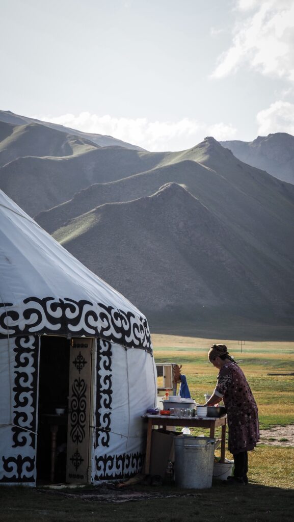
The best time to visit Naryn is from June to September, when the weather is mild, mountain roads are generally open, and most of the region’s top attractions are easily accessible. This is also the season when nomadic families move to the high pastures with their livestock, making it the perfect time to experience traditional yurt camps and Kyrgyz hospitality.
Spring (April to May)
Spring arrives slowly in Naryn due to its high altitude. While lower valleys begin to turn green, snow can still cover the surrounding mountains, and some high passes may remain closed. If you’re planning to visit alpine lakes or remote valleys, late May is generally a better choice than April.
Winter (October to March)
Winter in Naryn is long, cold, and snowy. Temperatures frequently drop well below freezing, and heavy snowfall can affect travel on mountain roads. While this isn’t the best season for sightseeing, it offers a completely different experience for travellers interested in snow-covered landscapes and authentic local life away from the tourist season.
Where to spend a night?
I spent a few nights at Pamko. The place was spacious and clean. There was also a mini kitchen area, and the owner was very friendly. They kept my luggage safe while I was staying overnight in Tash Rabat.
What to see in Naryn?
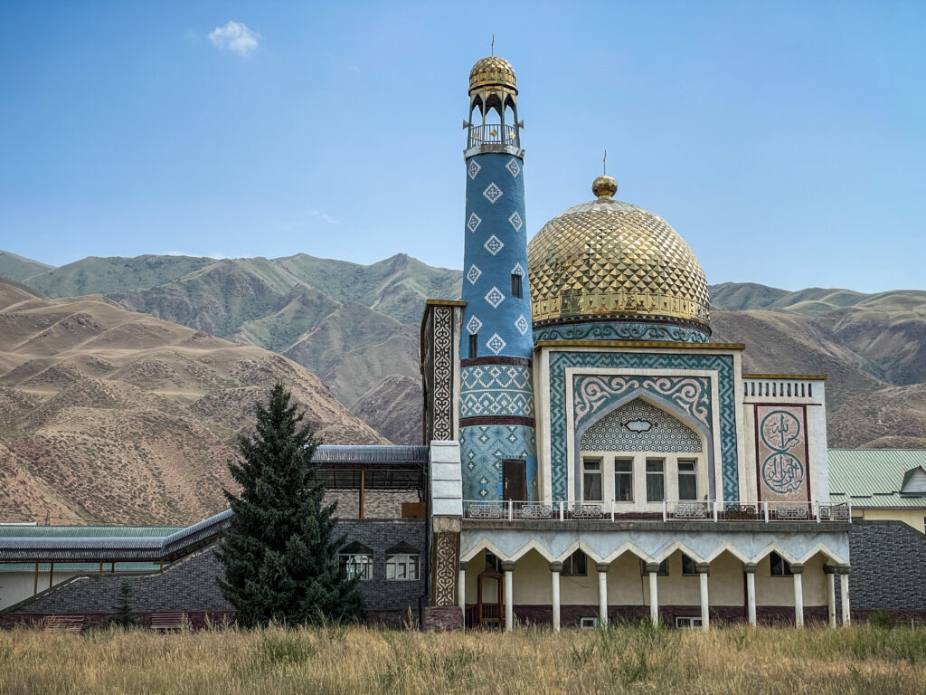
Naryn Central Mosque
The Naryn Central Mosque is one of the town’s most recognisable landmarks. Its modern architecture, elegant domes, and tall minarets stand out against the surrounding mountain scenery, making it a popular place to stop while exploring the town centre.
Visitors are welcome to admire the mosque from the outside, while those wishing to enter should dress respectfully and avoid visiting during prayer times.
Tsentral’naya Ploshchad’ (Central Square)
The Central Square is the heart of Naryn and a good place to experience the town’s relaxed atmosphere. Locals gather here throughout the day, especially in the evenings, and you’ll often find families walking, children playing, and people meeting with friends.
Surrounded by government buildings, small cafés, and shops, the square is a convenient starting point for exploring the rest of the town. If you visit during a national holiday or local celebration, there’s a good chance you’ll find concerts, cultural performances, or community events taking place here.
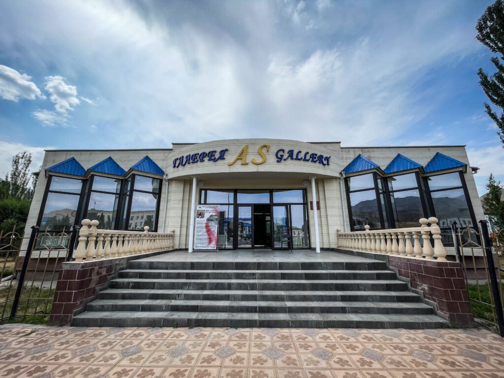
Naryn Art Gallery
If you’d like to learn more about Kyrgyz culture through art, the Naryn Art Gallery is worth a visit. The gallery showcases works by local artists, including paintings inspired by the region’s mountain landscapes, nomadic traditions, and everyday life in central Kyrgyzstan.
The exhibitions are relatively small, making it an easy stop that can be explored in less than an hour. It’s also a good opportunity to discover talented regional artists whose work is rarely displayed outside Kyrgyzstan.
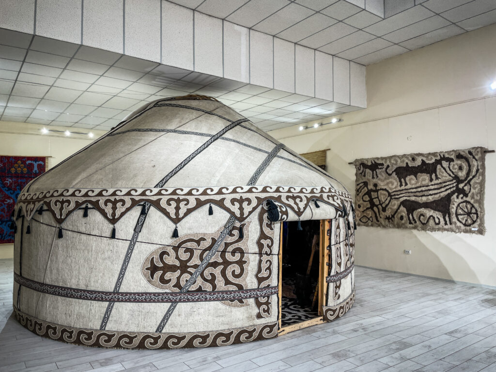
Istoriko-Etnograficheskiy Muzey (Historical and Ethnographic Museum)
The Historical and Ethnographic Museum offers an introduction to the history and traditions of the Naryn region. Its collection includes archaeological finds, historical photographs, traditional clothing, household items, and exhibits explaining the nomadic lifestyle that has shaped the area for centuries.
Although the museum isn’t large, it provides useful background before visiting nearby attractions such as Tash Rabat or Song-Kul Lake. Spending an hour here will help you better understand the culture, history, and daily life of the people who call this remote part of Kyrgyzstan home.
What to see near Naryn?
Salkyn Tor National Park
Just a short drive from the city of Naryn, Salkyn-Tor National Park is one of those places that locals know well but many travellers overlook. The park offers a refreshing mix of forests, rivers, and mountain scenery that feels worlds away from city life.
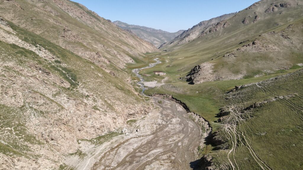
Eki-Naryn is a small high-mountain settlement in the Naryn region of central Kyrgyzstan, located in a broad valley shaped by the upper course of the Naryn River. The name of the place is closely tied to its geography: in Kyrgyz, eki means “two,” and Naryn refers to the river, pointing to the fact that this area lies near the meeting point of two headwater branches that together form the Naryn River. These branches descend from the surrounding Tien Shan mountains and converge in the valley, giving the location both its name and its physical character.
Hidden deep in the mountains of Kyrgyzstan, Tash Rabat feels like a place suspended between worlds. Once a resting point for traders moving along ancient Silk Road routes, today it marks the beginning of one of the most remote and rewarding treks in the region. Beyond its stone walls, the landscape quickly sheds any trace of civilisation, opening into vast valleys, high passes, and windswept plateaus.
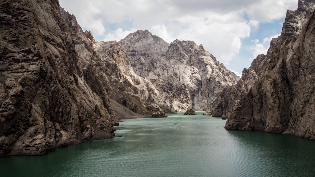
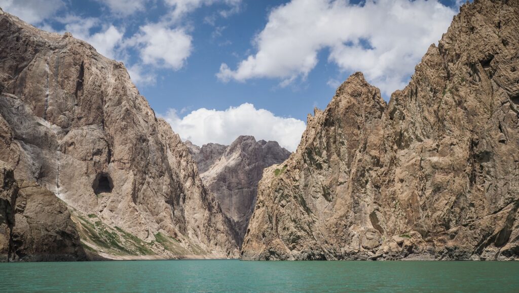
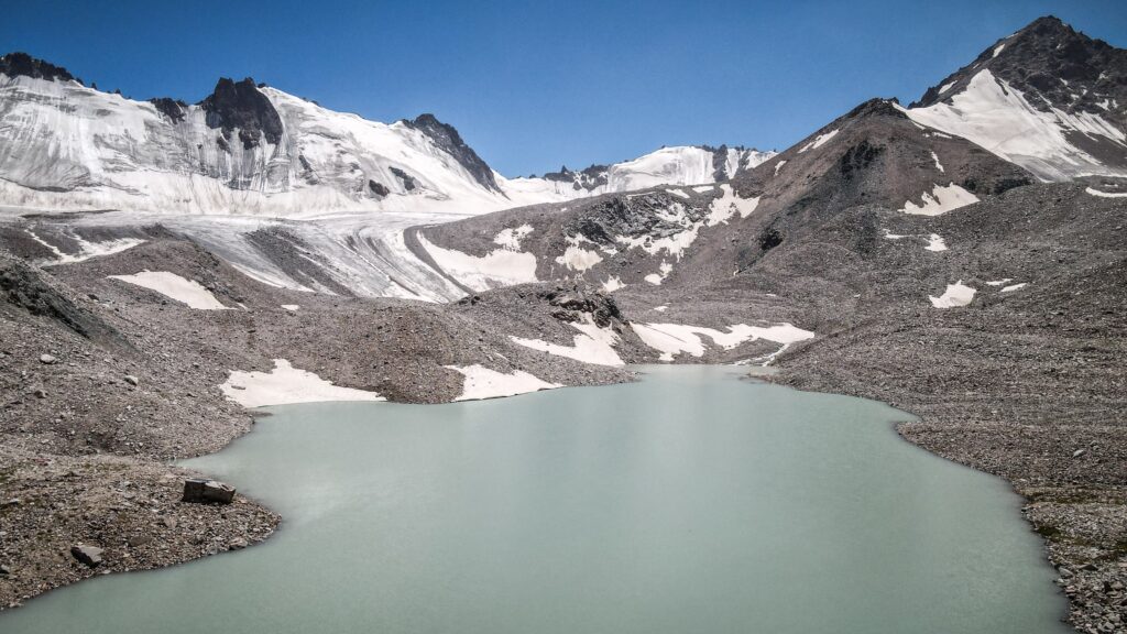
Kel-Suu is a remarkable high-mountain lake tucked into the rugged Naryn Region, very close to the border with China. It sits at a significant altitude of over 3,400 meters above sea level, surrounded by tall rocky ridges and dramatic alpine scenery that changes with the seasons.
The name comes from the Kyrgyz language and relates to the idea of “flowing” or transient water. This reflects one of the lake’s most unusual traits: its water level doesn’t always behave predictably. At times, much of the lake’s water can drain away through underground channels and caves, leaving behind stark stone landscapes; at other times, it fills up again with meltwater from nearby glaciers and snowfields.
Although it looks like a classic glacial lake, Kel-Suu was actually created in the 1980s when a massive landslide blocked a valley, and water began to accumulate behind the natural dam. Today, its waters stretch roughly 9 km in length and vary in width from several hundred meters to almost two kilometres in places, though it remains relatively shallow compared with some other alpine lakes.
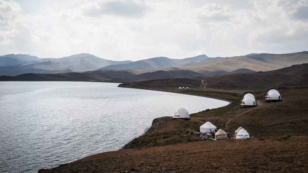
One of the defining aspects of Kel-Suu is how isolated it is. The approach leads through wide valleys, marshy ground, rivers, and high-altitude pastures, and because it lies within a border security zone, visitors must obtain a special permit ahead of time to enter the area. There’s no paved road all the way to the lake, so most travellers continue on foot or horseback from a yurt settlement in the nearby Kok-Kiya valley.
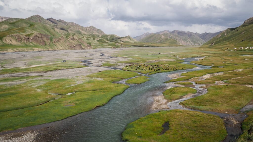
Song-Kul (also spelt Son-Kul) is the second-largest lake in Kyrgyzstan, but its true beauty comes from its isolation and natural surroundings. Sitting at an elevation of approximately 3,016 meters (9,895 feet) above sea level, Song Kul Lake is surrounded by endless grasslands, rolling hills, and dramatic mountain scenery. For travelers searching for authentic nomadic culture, peaceful landscapes, and an escape from busy cities, the lake is one of the most unforgettable destinations in Central Asia.
During summer, local nomadic families move their livestock to the high pastures around the lake, living in traditional yurts just as their ancestors did for centuries. The scenery changes constantly throughout the day. In the morning, the lake reflects snow-covered peaks like a mirror. By evening, the grasslands glow golden under the sunset while herds of horses wander freely across the plains.
Interesting Facts About Song-Kul Lake
It Freezes Completely in Winter
Because of its high elevation, Song-Kul experiences extremely cold winters. The lake usually freezes solid for several months, and temperatures can drop far below zero. During this period, many roads become inaccessible.
Nomads Still Live Traditionally Here
The area around Song-Kul is one of the best places to experience Kyrgyz nomadic culture. Families spend summer months raising sheep, horses, and yaks in the mountain pastures. Visitors can stay in yurts, taste homemade dairy products, and learn about local traditions firsthand.
The panorama of Song Kul Lake
Horses Are Everywhere
Horses play a huge role in Kyrgyz culture, and Song-Kul is famous for its horseback riding routes. Many travelers explore the lake by horse, crossing valleys and mountain passes with local guides.
The Night Sky Is Incredible
With almost no light pollution, Song-Kul offers spectacular stargazing. On clear nights, the Milky Way becomes clearly visible across the sky, making it a dream destination for photographers and nature lovers.
It Was Once Part of Ancient Silk Road Routes
The region surrounding Song-Kul was historically connected to ancient trading paths crossing Central Asia. Nomads and merchants once traveled through these mountain areas while moving between East and West.
How to get to Song Kul Lake?
By Car
Most travelers begin their journey in Bishkek, the capital of Kyrgyzstan. From there, the trip to Song-Kul usually takes between 5 and 7 hours by car depending on road conditions.
The easiest way to reach the lake is by hiring a driver or joining a tour. If you drive yourself, the easiest and most practical road for a normal 2WD car or shared minibus to reach Song-Kul Lake is generally considered to be the Karakeche Route (Bishkek → Kochkor → Chaek/Jumgal → Karakeche Pass → Song-Kul) from the Jumgal side. It is often described as the most accessible pass for regular vehicles.
Other mountain passes leading to Song-Kul can be steep and difficult for standard cars.
Horse Trekking
For adventurous travelers, multi-day horseback tours to Song-Kul are extremely popular. These trips often begin in towns such as Kochkor or Kyzart and include overnight stays in yurts.
On Foot
The northern shore of Song-Kul Lake can be comfortably reached on foot from Kyzart in a single day. The route crosses the scenic Tuz Ashuu Pass at 3,233 meters and stretches for roughly 25 kilometers, usually taking between six and eight hours depending on pace and weather conditions.
For the return journey, I chose a different route, hiking over the Jalgiz Kara Pass at 3,326 meters before continuing through Chaar Archa at 3,043 meters and eventually descending to the A367 road, where I managed to hitchhike back to Kyzart. It turned into another long but rewarding day in the mountains, covering close to 30 kilometers in around seven hours.
The best time to visit Song Kul Lake
The best time to visit Song-Kul Lake is during the short summer season between mid-June and mid-September, when the high mountain pastures turn green and the remote roads finally become accessible after the long winter. This is the period when nomadic families move to the lake with their livestock, filling the valleys with yurts, horses, and traditional daily life that makes the region feel so unique. July and August are generally the warmest and most comfortable months, offering long daylight hours, clear mountain views, and ideal conditions for hiking, horseback riding, and camping.
Even in the middle of summer, however, temperatures can change quickly at over 3,000 meters above sea level, with cold nights, strong winds, and occasional storms arriving without warning. Early summer often brings lush landscapes covered in wildflowers, while September offers quieter trails, golden grasslands, and crisp autumn air before the first snowfall begins closing the mountain passes again. Outside of summer, Song-Kul becomes an isolated and extremely harsh environment, with heavy snow, frozen roads, and temperatures far below freezing, making travel much more difficult.
The panorama of Song Kul Lake
Where to spend a night?
In Kyzart, I recommend Mira Guest House, and on the shore of Song Kul Lake – Yurt Camp Tuzashuu Azamat.
My experience
Day 1
I arrived in Kyzart fairly late in the day, and since the hike to Song-Kul Lake was supposed to take around five or six hours, I knew I had little time to waste. After finding a guesthouse through Google Maps, I stopped briefly to arrange a room for the following night and ask whether I could safely leave my car there.
Once everything was sorted, I quickly repacked my gear and headed toward the lake. The road at first felt endless and rather monotonous. After crossing a bridge, a group of horse riders passed me, and not long after I noticed a car approaching. On impulse, I decided to try hitchhiking, and to my surprise the driver stopped immediately. As it turned out, he was heading exactly where I was going because his parents owned yurts near the lake. It felt like unbelievable luck.
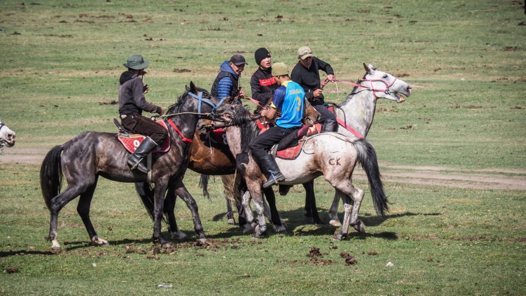
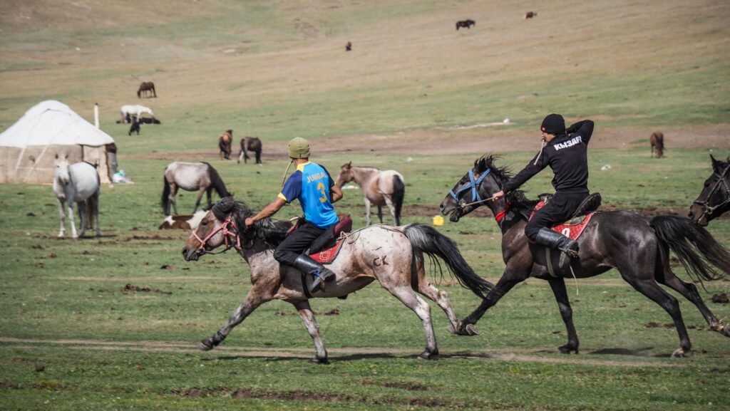
Since the road apparently stayed uneventful until the Tuz Ashuu Pass (3233 m), I was more than happy to save both time and energy. Before reaching the top, we paused for a short break to cool down the overheated car engine, then continued onward until we came across a group of Kyrgyz men playing the traditional horseback game involving a goat carcass. We stopped to watch for a while, and I ended up taking countless photos.
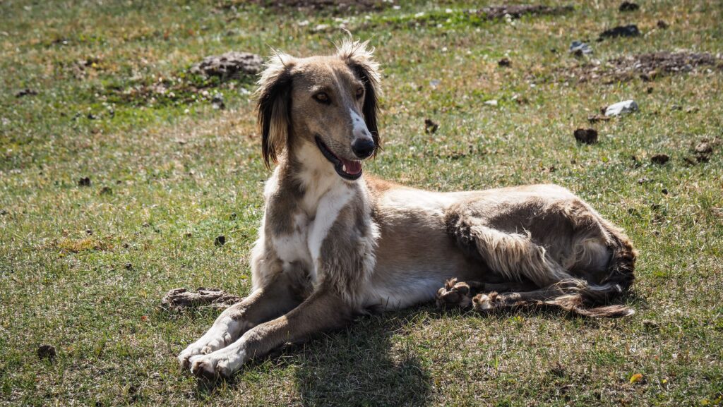
The view from Tuz Ashuu PassLocals playing Kok Boru gameLocals playing Kok Boru gameMongolian Taiga dog is a breed of sighthound from Kyrgyzstan
Around that moment, however, the driver told me he expected 1,000 som for the ride. Although he had been friendly throughout the journey, the amount felt excessive and slightly spoiled what had otherwise been such a fortunate encounter. On the other hand, chipping on to the fuel costs while hitchhiking in Kyrgyzstan is perfectly normal.
After arriving at the lake, I wandered down to the shoreline and climbed a small hill for a better panorama. At one point I noticed a man bathing in the freezing water alongside his horse, which felt wonderfully surreal even by Kyrgyzstan standards. As I continued walking along the shore, dark storm clouds began gathering over the mountains, and I started wondering whether I would reach the yurt camp before the rain arrived. Thankfully, I made it just in time. I pitched my tent and then I headed inside the yurt to ask about dinner.
By then the weather had turned cold and extremely windy. Inside the yurt, I met a group of women on a horseback riding tour — mostly Scandinavians along with a few particularly loud and stereotypically British travelers — while I quietly drank tea and observed the lively atmosphere around me.
Shortly before dinner, one of the local Kyrgyz men approached and insisted that sleeping in the tent would be too cold, offering me a bed inside the yurt instead. He told me to pack up my tent and move indoors, which I accepted very gratefully. Dinner was simple but satisfying, much like most meals in mountain yurt camps, and despite the freezing night outside, the thick blankets and my jacket kept me surprisingly warm. In the end, they only charged me for dinner and refused to take any extra money for the bed. It was an incredibly kind gesture.
Looking back, the entire day felt chaotic and unpredictable, with almost nothing going according to plan, yet somehow everything worked out perfectly in the end. Had I not hitchhiked, I almost certainly would have been caught in the storm, and I doubt I would have managed the long return hike to Kyzart the following day. Instead, the day ended with shelter, warmth, and unexpected hospitality.
Day 2
I set off around 6 AM, and the morning was absolutely beautiful. The soft early light covered the landscape, the air was perfectly still, and the mountains across the lake stood out sharply beneath a deep blue sky. It was cold, but pleasantly so, with almost no wind.
The panorama of Song Kul Lake
After reaching Jalgiz KaraPass (3326 m) and beginning the descent, I finally encountered the first group of hikers. Honestly, although the trek is certainly long for a single day, an early start makes it completely manageable, so I was a bit surprised that most people choose to split it into two days and stay overnight in the yurts along the route.
Beyond the yurt camps, the trail climbed again before continuing across a long, mostly flat section along the mountainside. Eventually, the path rose toward Chaar ArchaPass (3043 m), though in general the climbs on this hike felt fairly gentle rather than steep. At the top, I met a man sitting in his car and we exchanged a few words in my very limited Russian.
From there, the long descent toward the road began, and by that point I was starting to feel truly exhausted. Fortunately, I was picked up almost immediately by a truck driver. On the way toward Kyzart, he and his friend stopped by a river for a quick wash, which felt like a very normal mountain-road moment. They later dropped me off at the turnoff for the village, and as I continued walking, another car soon pulled over and offered me a ride the rest of the way. The driver turned out to be a local guide, and he was incredibly kind and welcoming.
What to see and do around Song Kul Lake
Explore the Area on Horseback
Many of the yurt camps around Song-Kul Lake organize horseback rides directly from the lakeshore, making it easy for visitors to explore the surrounding mountains and pastures without needing any previous riding experience. Short rides usually follow the shoreline or nearby hills, while longer excursions venture deeper into the wide alpine valleys and remote grazing areas used by nomadic shepherds during summer. Riding across the open grasslands with herds of horses scattered across the landscape feels like the most natural way to experience Song-Kul, especially in a region where horses remain central to everyday life. Local guides from the yurt camps often lead the trips, sharing hidden viewpoints, quiet valleys, and panoramic mountain scenery that would be difficult to reach on foot. Even for beginners, these rides are usually relaxed and accessible, turning horseback travel into one of the most memorable experiences at the lake.
The panorama of Song Kul Lake
Watch Traditional Nomadic Games
With a bit of luck, you might come across a game of Kok Boru being played on the open pastures around Song Kul Lake. The traditional sport, played entirely on horseback, is intense and surprisingly physical, with riders battling for control of a goat carcass while galloping across the field at full speed. From a distance it can look almost chaotic, but the game has deep roots in the nomadic history of Central Asia and remains an important part of Kyrgyz culture today. Watching the riders manoeuvre their horses with incredible skill and precision offers a fascinating glimpse into the strong connection between the Kyrgyz people, horses, and life on the steppe.
Visit Ancient Petroglyphs
Beyond the sweeping landscapes and nomadic traditions, the surroundings of Song-Kul Lake also preserve quiet traces of an ancient past. Hidden among the hills and rocky slopes are scattered petroglyphs carved into stone by early peoples who once travelled through these high mountain valleys centuries ago. Many of the engravings portray wild animals such as ibex, deer, wolves, and horses, alongside hunting scenes and strange symbolic markings whose meanings have long been forgotten. Unlike the well-known petroglyph fields near Cholpon-Ata, the carvings around Song-Kul remain largely unnoticed, which makes stumbling upon them feel far more authentic and rewarding. Some require short detours away from the main trails or yurt camps, adding a small sense of discovery to the experience.
Drive Moldo-Ashuu
Moldo-Ashuu Pass is one of the scenic mountain passes connecting the remote highlands around Song-Kul Lake with the valleys further south. Rising above 3,000 meters, the pass offers wide panoramas of rolling grasslands, rugged mountain ridges, and the endless open landscapes that make central Kyrgyzstan feel so wild and untouched. The road crossing the pass is rough and winding, but the journey itself is part of the experience, passing through isolated summer pastures dotted with yurts, grazing horses, and shepherd camps.
From Song-Kul Lake, Moldo-Ashuu can be reached by following the southern road heading toward the Naryn region. In dry conditions, the road can be driven in any car as it is good gravel. The drive from the lakeshore to the pass usually takes a couple of hours depending on weather and road conditions, with several scenic viewpoints along the way.
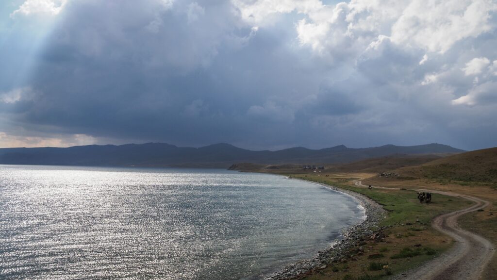
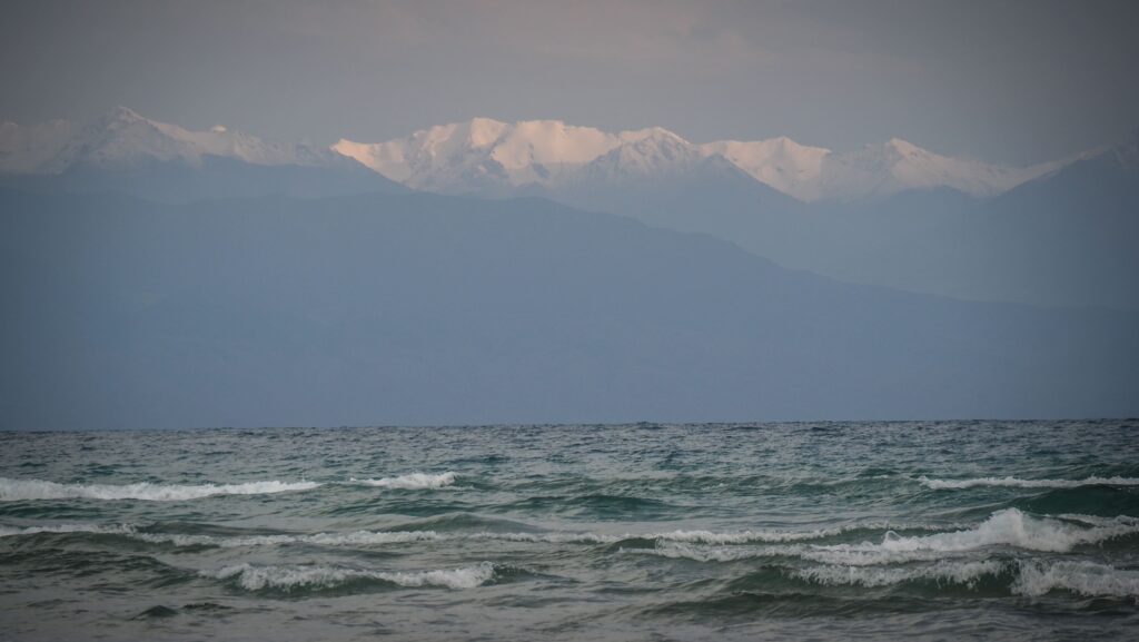
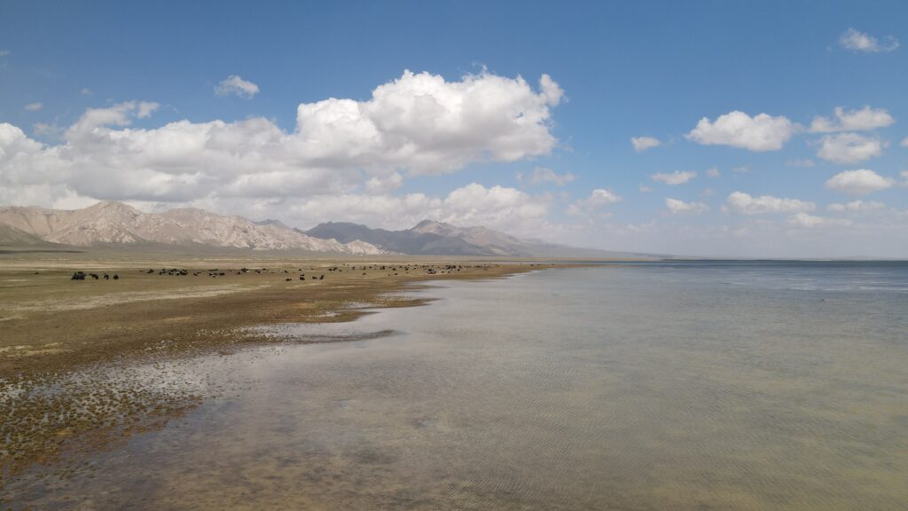
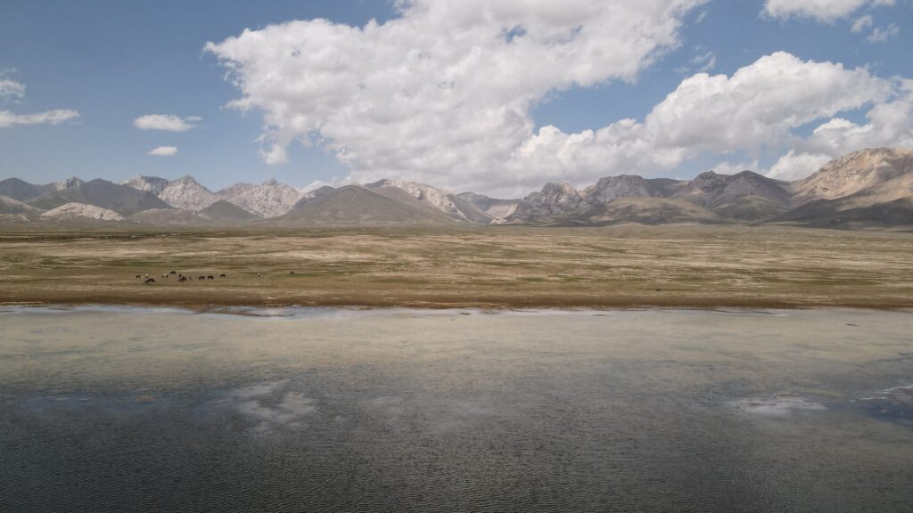
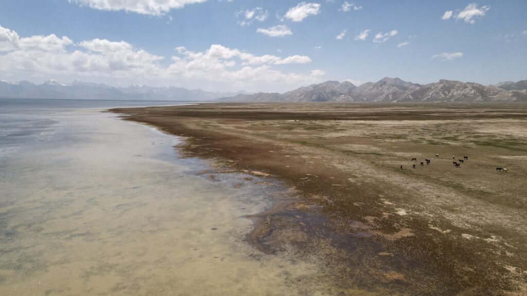
There’s something quietly magnetic about the north coast of Issyk Kul. Maybe it’s the way the lake stretches out like an inland sea, framed by distant, snow-dusted peaks, or how the light shifts throughout the day -soft and silver in the morning, warm and golden by evening. Life here feels a little slower, a little more grounded, as if the rhythm of the water sets the pace for everything else.
Issyk Kul itself is one of those places that feels almost improbable when you first encounter it. A vast alpine lake sitting at around 1,600 meters above sea level, it’s one of the largest high-altitude lakes in the world. Despite the region’s harsh winters, it never freezes thanks to its slight salinity and remarkable depth, reaching over 600 meters in places. Stretching roughly 180 kilometers in length, the lake almost looks like a sea, especially when the wind picks up and small waves roll toward the shore. Locals have long called it the “Pearl of Kyrgyzstan,” and it’s easy to see why as its clear waters shift from deep blue to turquoise depending on the light, all set against the dramatic backdrop of the Tian Shan mountains.
Along north shoreline, you’ll find a mix of beach towns, roadside cafés, and unexpected pockets of culture. Families gather for summer swims, travelers linger over grilled fish and fresh bread, and locals carry on traditions shaped by both nomadic roots and Soviet-era echoes. It’s not polished or overly curated and maybe for some that’s part of the appeal.
During my two months traveling through Kyrgyzstan, I kept getting asked the same question: “Have you been to Issyk Kul yet?” It’s clearly a favorite getaway for locals, especially in the summer. That said, I found the north coast a bit underwhelming compared to the south. It feels more developed, a little kitschy in places, and in peak season you’ll notice a heavy influx of very often drunk Russian tourists, with a party atmosphere that starts surprisingly early in the day. The south shore, on the other hand, is absolutely stunning but that’s a story for another time. Still, if you do find yourself driving along the northern side, there are definitely a few spots worth pulling over for.
How to get to the north coast of Issyk Kul?
Getting to the north coast of Issyk Kul is fairly straightforward, especially if you’re starting from Bishkek. Most people make the trip by road, and it’s part of the experience rather than just a transfer.
The easiest option is a shared minibus (marshrutka) from Bishkek’s western bus station. They run frequently during the day and head to towns like Cholpon-Ata or Balykchy along the northern shore. It’s cheap and relatively quick, usually around 4 to 5 hours depending on traffic and how many stops the driver makes along the way. Just be prepared for a slightly cramped ride if it’s full.
If you prefer a bit more comfort, you can arrange a private taxi. It’s obviously more expensive, but if you’re traveling with others it can be worth it. You’ll have more flexibility to stop along the way, which is nice because the scenery gradually shifts from flat steppe to mountain-framed lake views.
Renting a car is another solid option if you’re comfortable driving. The roads are generally in decent condition, and having your own vehicle makes it much easier to explore different parts of the coastline at your own pace. The drive itself is simple: you head east from Bishkek, passing through the Boom Gorge before reaching Balykchy, where the lake first comes into view.
There’s also a train that runs from Bishkek to Balykchy, but it’s slow and more of a scenic, nostalgic option than a practical one. If you’re not in a rush, it can be a pleasant way to arrive. HERE is the website of Kyrgyz Railway.
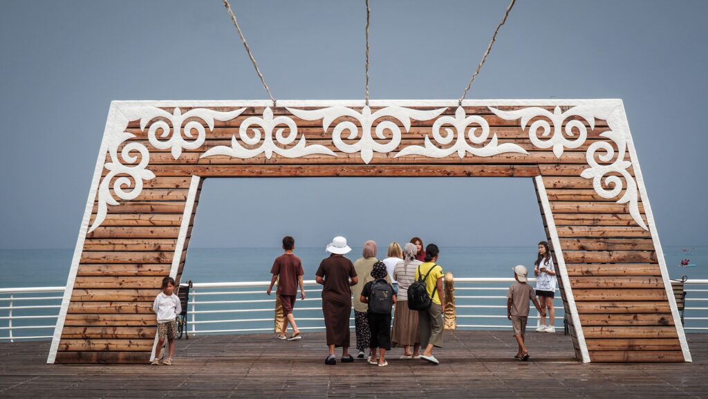
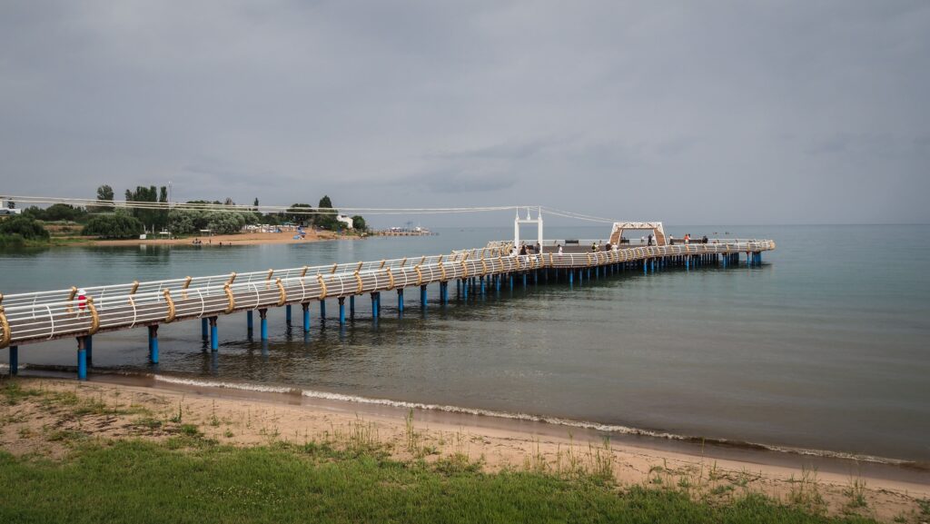
Pier in Cholpon Ata
The best time to visit Issyk Kul
The best time to visit the north coast of Issyk Kul really depends on what you’re looking for, but for most people, it’s firmly a summer destination.
July and August are peak season, when the weather is warm enough to actually enjoy the lake. Daytime temperatures usually sit somewhere between 25–30°C, and the water is comfortable enough for swimming. This is when the whole area feels alive: beaches fill up, cafés are busy, and there’s a kind of holiday atmosphere everywhere. The downside is that it can get crowded and a bit chaotic, especially around Cholpon-Ata.
If you prefer something quieter, June and September are a nice middle ground. The weather is still pleasant, just a bit less intense, and there are fewer tourists around. September in particular has a calmer feel to it as the water is still relatively warm from the summer, but the crowds have thinned out, and everything slows down again.
Outside of those months, the north coast gets pretty quiet. Spring can be unpredictable, with cooler temperatures and fewer places open, while winter is cold and not really suited for a classic lake trip. It has its own kind of stark beauty, but it’s a completely different experience.
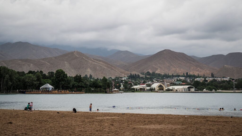
Issyk Kul Lake and mountains in the background
Where to spend a night?
Cholpon Ata
I spent a few nights at Olga Guesthouseand Helena Guesthouse. Both were perfectly decent—nothing fancy, but comfortable enough and did exactly what I needed. They have that typical, homey guesthouse feel, with access to a shared kitchen and hosts who are happy to help arrange trips out to Grigorevskoe Gorge.
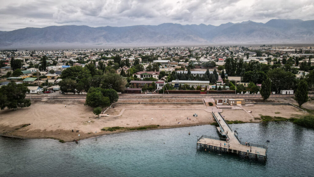
Balykchy
Here a good option is to stay at Visit Balykchy. The room is spacious and very comfortable though a bit old but it’s fine. The owner is really nice.
What to see and do at the north coast of Issyk Kul?
Balykchy
Sitting right at the western edge of Issyk Kul, Balykchy often feels more like a transit point than a destination but it has a story of its own if you slow down a bit. The town’s name comes from the Kyrgyz word balyk, meaning “fish,” which makes sense given its location. Fishing has long been part of life here, and even today the name reflects that connection to the lake. During the Soviet period, the town was renamed Rybachye (which also means “fisherman” in Russian), before returning to its original Kyrgyz name after independence. Its position made it an important hub, especially as a rail terminus and a key stop on the road circling the lake.
Historically, Balykchy has always been about movement – traders, travelers, and goods passing through rather than staying. That still shapes the atmosphere today. It’s not as polished or resort-like as other parts of the north shore, but there’s something honest about it: wide streets, a slightly worn feel, and glimpses of everyday life rather than curated tourist scenes.
Balykchy isn’t packed with major attractions, but it has a few places worth checking out, especially if you’re passing through.
The beach in Balykchy
Plyazh Aliya
This is one of the more accessible beaches in town, and it has local feel. You won’t find anything too fancy here, just a stretch of shoreline where people come to swim, hang out, and escape the heat. On a warm day, it’s a good spot to pause, dip your feet in the lake, and watch life unfold around you.
Sayakbay Karalayev monument
A statue dedicated to Sayakbay Karalayev, one of the most famous manaschi (oral storytellers of the epic Manas), stands in Balykchy as a reminder of Kyrgyzstan’s deep storytelling traditions. Even if you’re not familiar with the epic itself, it’s an interesting cultural stop and a glimpse into how important oral history still is in the region.
Novyy Plyazh Balykchy (New Beach)
As the name suggests, this is a more recently developed beach area. It’s a bit more organized than the older spots, with some basic facilities and a slightly more modern feel. In summer, it draws a mix of locals and visitors looking for an easy place to swim without heading further along the coast.
Cholpon Ata
If Balykchy feels like a gateway, Cholpon-Ata is where the north shore really shifts into full-on resort mode. This is the main hub along Issyk Kul with hotels, sanatoriums, beach clubs, and long promenades that fill up quickly in summer.
The town grew significantly during the Soviet era, when Issyk Kul became a popular health and holiday destination. Many of those old resorts are still standing today, some renovated, others a bit frozen in time. The name “Cholpon-Ata” roughly translates to something like “Father of the Morning Star,” which feels oddly poetic for a place that now buzzes with beachgoers, jet skis, and late-night music in high season.
It’s definitely more built-up, touristy and kitschy than other parts of the lake.
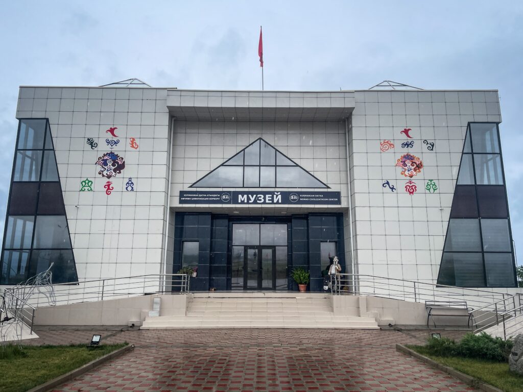
Nomad Civilization Center
This place tries to capture the broader story of Kyrgyz nomadic life, past and present. It’s not a huge complex, but it gives a decent overview of traditions, crafts, and how people adapted to life on the move. Think yurts, cultural displays, and a bit of context for everything you see elsewhere in the country. It is located a bit out of town but can be easily reached by taxi. Try to flag down a marshrutka or simply hitchhike on the way back. Please note that in Kyrgyzstan hitchhiking is very common but small payment is expected!
Nomad Civilization Center
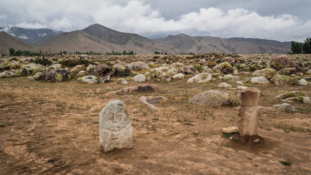
Petroglyphs Museum
Just outside town, this open-air site is one of the more interesting stops in the area. Scattered across a field are ancient rock carvings, some dating back thousands of years, depicting animals, hunting scenes, and everyday life. There’s something special about walking among these stones with the mountains in the background.
Petroglyphs Museum in Cholpon Ata
Ysyk-Köl Historical-Culture Museum
If you want a bit more structure and explanation, this museum dives into the region’s history from ancient tribes to Soviet times. It’s not overly polished, but it helps piece together the cultural layers of Issyk Kul and the surrounding region.
Rukh Ordo
Probably the most visually distinctive place in Cholpon-Ata, Rukh Ordo is a lakeside complex that mixes spirituality, art, and national identity. There are small chapels representing different religions, sculptures, and open spaces leading right down to the water. It feels a bit symbolic and kitschy, but the setting, especially at sunset, makes it worth a visit.
Pier in Rukh Ordo Complex
Termal Hot Springs
Here you’ll find a few hot spring spots where you can soak in mineral-rich water. They’re usually pretty simple, more functional than luxurious, but after a long day or a dusty drive, it’s a nice way to unwind.
Yakht-Klub “Kruiz”
For something a bit different, this yacht club offers a more “resort-style” experience. You can watch boats come and go, sit by the water, or even head out onto the lake if you’re feeling like doing something more active.
Beaches
Cholpon-Ata is really all about the beaches, and there’s no shortage of them. Each one has a slightly different vibe:
Cholpon Ata Gorodskoy Plyazh The main public beach—busy, central, and full of energy in summer. Expect crowds, music, and plenty of places to grab food or rent a sunbed.
Plyazh Keysar A bit more organized and slightly more upscale, with better-maintained facilities. It tends to attract people looking for a more comfortable beach day.
Gorodskoy Plyazh “Kaganat” Somewhere in between—still lively, but often a bit less chaotic than the main city beach. A decent option if you want the atmosphere without the biggest crowds.
Plyazh A B More low-key and less polished, this one feels a bit closer to a “local” beach. Fewer amenities, but also fewer people, especially if you walk a little further from the main access points.
Beach in Cholpon Ata
Bosteri
Just a short drive west of Cholpon-Ata, Bosteri has built a reputation as one of the liveliest and at times most chaotic spots along the north shore of Issyk Kul.
Originally a small lakeside village, Bosteri grew quickly during the Soviet years as holiday resorts and sanatoriums started popping up along this stretch of coast. Today, it feels like a mix of old-school resort town and slightly improvised amusement zone. It’s less polished than Cholpon-Ata, a bit louder, and very much geared toward summer crowds looking for entertainment as much as relaxation.
In peak season, the place buzzes with families, groups of friends, and plenty of visitors from neighboring countries. There’s a noticeable “holiday park” vibe, especially near the waterfront.
One of Bosteri’s most recognizable features is its small amusement area, complete with a Ferris wheel that rises above the shoreline. It’s a bit worn, a bit nostalgic, and somehow fits perfectly with the overall feel of the place. Nearby, you’ll find water slides and plenty of snack stalls selling everything from shashliks to ice cream.
The beach itself is wide and easy to access, with shallow water that makes it popular for swimming. It’s not the quietest stretch of Issyk Kul as music plays, jet skis buzz around, and there’s always something happening. Personally, it is the kind of place that I would never come back to but if you’re in the mood for energy rather than solitude, it works.
Accommodation in Bosteri ranges from simple guesthouses to larger resort complexes, often at slightly lower prices than in Cholpon-Ata.
Semenovka and Grigorevka Gorges
I signed up for an organized tour and got a seat in a rather old 4×4, as it’s difficult to reach the gorges without your own wheels. The trip took us along the northern shore of Issyk-Kul, through the famous Semenovka Gorge and Grigorevka Gorge. Both valleys are well-known tourist spots because they are relatively close to Cholpon-Ata and easy to access compared to the more remote mountain regions of the country.
Semenov Gorge is one of the most visited mountain valleys near Issyk-Kul, mainly because it is easy to reach from the lakeside resorts. The gorge cuts deep into the Tian Shan mountains and is covered with spruce forests, grassy meadows, and fast mountain streams fed by snowmelt. In summer, many nomadic families bring their animals there to graze on the high pastures, while tourists arrive in jeeps and minibuses for short trips into the mountains. The place is named after the Russian explorer Pyotr Semyonov-Tyan-Shansky, who explored the region during the nineteenth century. Despite its beautiful scenery, the gorge nowadays feels quite commercialized, with picnic spots, yurts, and crowds of visitors almost everywhere during the season.
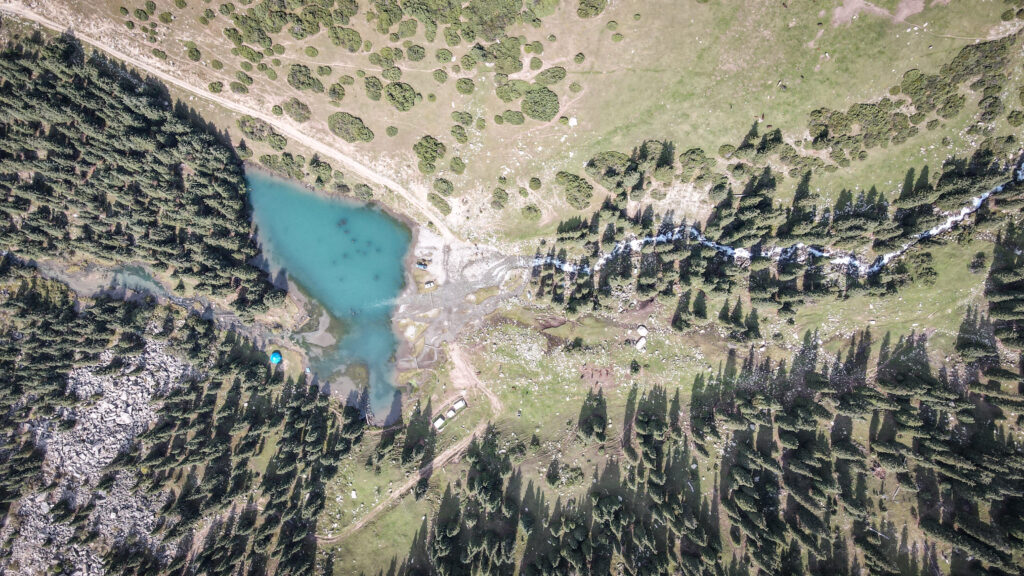
We visited a small alpine lake there – Süttüü-Bulak. The road was extremely bumpy, full of rocks and mud, and the old Soviet-style jeep shook nonstop the entire way. The gorge itself was green and pleasant, with spruce forests, grazing horses, and cold mountain rivers running through it, but after all the dramatic landscapes I had already seen in Kyrgyzstan, it felt rather underwhelming. The area is popular with local tourists because of its easy access and picnic spots, and there were yurts and tour groups everywhere.
Suttuu-Bulak LakeMountains around Suttuu-Bulak Lake
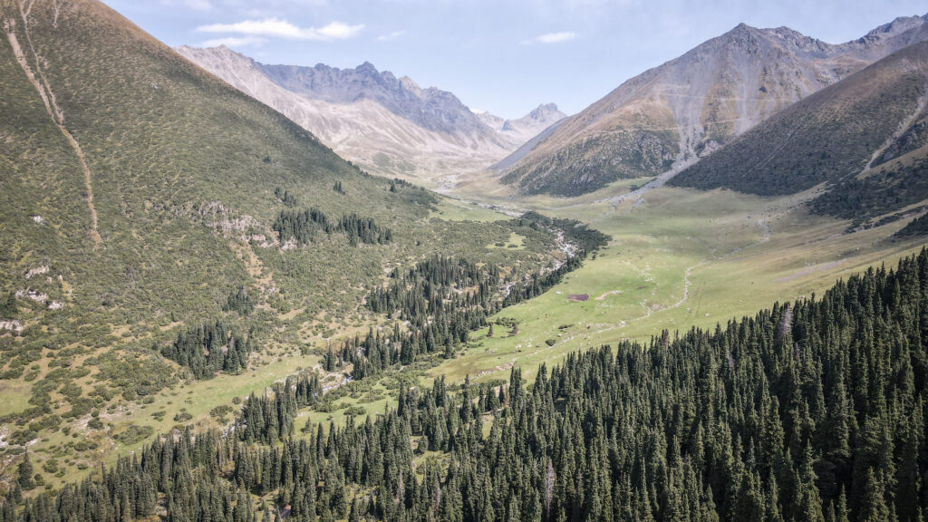
Then we continued to Kyrchyn View and then through Grigorevka Gorge. It has a similar atmosphere but feels slightly wider and greener, with long valleys stretching toward the snowy peaks of the Kungey Ala-Too range. The name comes from the period of the Russian conquest of Central Asia, when many places in Kyrgyzstan were renamed by Russian settlers and military administrators. The gorge was named after a Russian official or military figure called Grigoriev, although the exact historical identity is somewhat unclear today. Like many geographical names around Issyk-Kul, the Russian version replaced older Kyrgyz names during the nineteenth century when the region became part of the Expansion of the Russian Empire into Central Asia.
The gorge has traditionally been used as a jailoo, a summer pasture where shepherds live in yurts for several months each year. Horses wander freely through the valley, and many visitors stop to drink kumis or take horse rides deeper into the mountains. A cold glacial river runs through the gorge, and the whole area is filled with camps, yurts, and roadside cafés catering to tourists coming from nearby Issyk-Kul resorts. We had lunch there beside the river, surrounded by loud groups and off-road vehicles. The place certainly had atmosphere, but it lacked the wild, untouched feeling of the more remote places I had visited earlier in the trip.
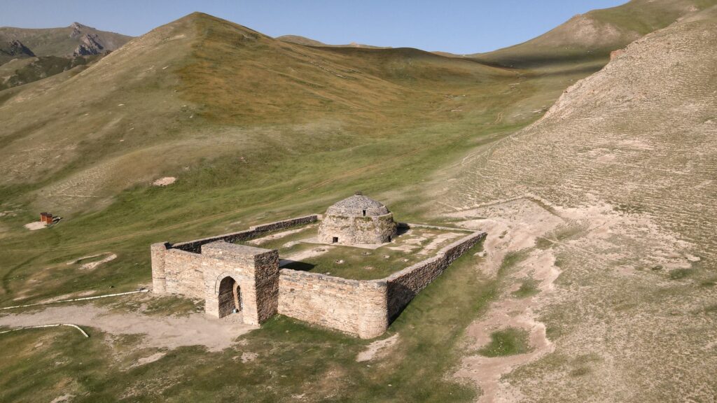
Hidden deep in the mountains of Kyrgyzstan, Tash Rabat feels like a place suspended between worlds. Once a resting point for traders moving along ancient Silk Road routes, today it marks the beginning of one of the most remote and rewarding treks in the region. Beyond its stone walls, the landscape quickly sheds any trace of civilization, opening into vast valleys, high passes, and windswept plateaus.
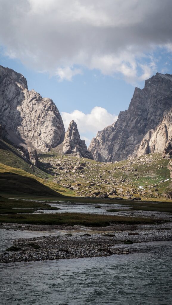
The journey from Tash Rabat to Chatyr-Kul Lake is simply spectacular. Crossing Panda Pass, you leave behind the green valley and step into a stark, expansive world where the horizon stretches endlessly and the air grows thinner with every step. There are no crowds, no marked trails guiding your way, just the rhythm of walking, the sound of the wind, and the sense of moving through a landscape that has changed little for centuries.
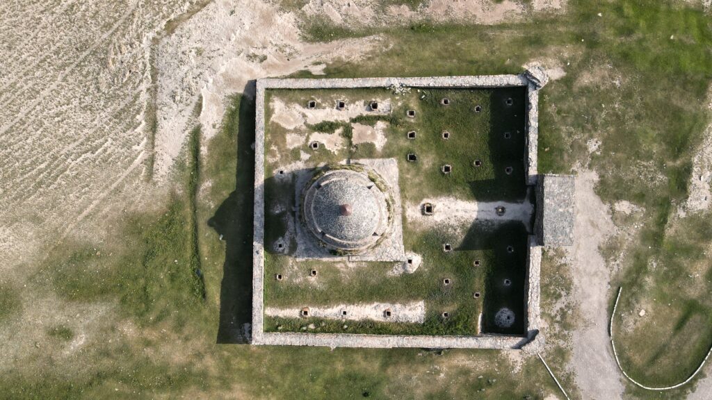
What is Tash Rabat?
Tash Rabat is one of the most unusual historical sites in Kyrgyzstan, not only because of its remote setting but also because of its structure. Built almost entirely from stone, it sits at about 3,200 meters above sea level in a quiet valley surrounded by mountains. Its isolated position makes it feel far removed from the trade networks it once served, yet that was precisely its purpose.
The building is believed to date back several centuries, most likely functioning as a caravanserai, a shelter for merchants and travelers moving along Silk Road routes. What makes it stand out is its design: instead of the typical open courtyard seen in many caravanserais, Tash Rabat is a compact, enclosed structure with thick walls and a series of small domed rooms connected by narrow passageways. In total, there are around 30 chambers, which were likely used for sleeping, storage, and possibly even animals.
Its fortress-like appearance has led to different theories about its original use. Some suggest it may have also served religious purposes, possibly as a monastery at some point, though its exact history isn’t fully documented. Inside, the atmosphere is dim and cool, even in summer, and walking through the stone corridors gives a sense of how travelers once took refuge here from harsh mountain conditions.
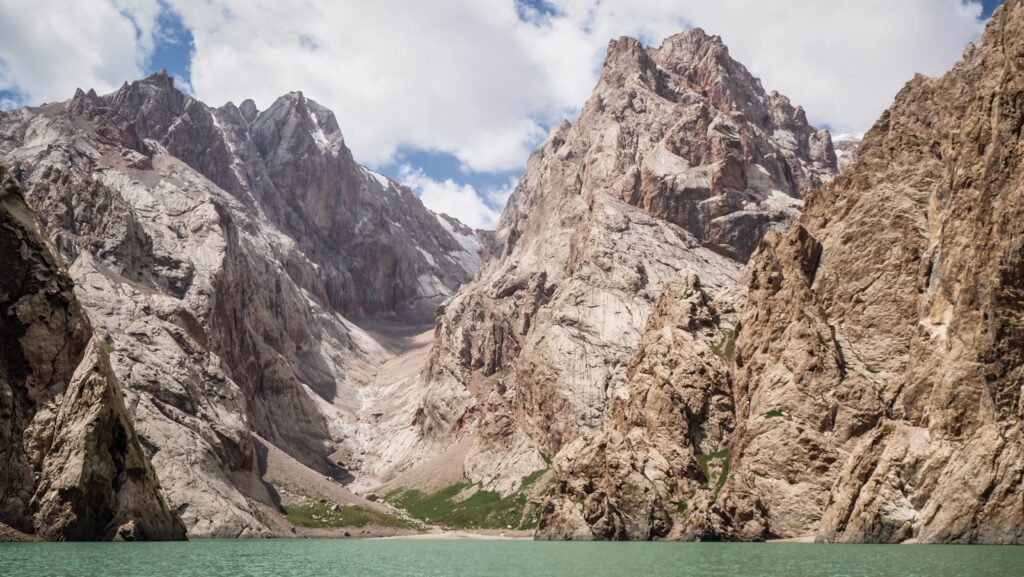
What is Chatyr Kul?
Chatyr-Kul Lake lies even deeper in the mountains, at an elevation of around 3,500 meters, close to the border with China. It is one of the highest large lakes in Kyrgyzstan and feels completely different from the green valley of Tash Rabat.
The lake stretches across a wide, open basin, surrounded by barren hills and distant mountain ridges. Unlike alpine lakes framed by forests, Chatyr-Kul has a stark, almost desert-like atmosphere. Vegetation is sparse, and the colors are dominated by shades of brown, grey, and pale blue. The water itself can appear calm and glassy one moment, then rough and wind-whipped the next.
An interesting feature of the lake is that it is slightly saline, which affects both its ecosystem and how it freezes in winter. The area is part of a protected reserve, and although it looks empty, it supports wildlife adapted to harsh conditions, including migratory birds that stop here during seasonal movements.
Because of its location in a border zone, access is controlled, which helps preserve its untouched character. There are no permanent settlements around the lake, and only occasional shepherd camps appear during warmer months. The sense of isolation is one of its defining features as you won’t find infrastructure, marked viewpoints, or tourist facilities here.
How to get to Tash Rabat?
From Naryn, the route goes south toward At-Bashi village. Then, continue about 100 km deeper into the mountains. The last stretch is on a dirt road, which is in very good condition, so perfectly doable in a normal car.
The easiest is to hire a private car / taxi in Naryn or At-Bashi. Many drivers are used to taking travelers there and you can find them hanging around the bus station. Just don’t forget to negotiate the price 🙂
My driver, Mars, turned out to be just as memorable as the journey itself. He had a great taste in music, which played constantly in the background as we drove through the mountains in his sturdy 4×4, adding a relaxed, almost cinematic feel to the ride. He dropped me off at Tash Rabat early in the morning, right as the valley was waking up, and then returned the following day in the early afternoon to pick me up – exactly as planned, reliable and easygoing the whole time. You may contact him if you need a transfer anywhere around Naryn. Phone number: +996 702 857 367.
Self-driving is another good and very straightforward option, if you have your own vehicle.
The aerial view of Tash Rabat
How to get to Chatyr Kul?
Starting from Tash Rabat, the route to Chatyr-Kul Lake via Panda Pass feels less like a marked trail and more like a gradual transition from a wide valley into high alpine wilderness.
You begin by walking straight out of the Tash Rabat valley, heading upstream along the river that cuts through the grassy basin. At first the terrain is gentle and open, with a visible path used by shepherds and animals. The caravanserai quickly disappears behind you, and the valley slowly narrows as you move deeper into the mountains. Early on, you’ll need to cross a couple of streams. These are usually manageable in summer, but can be cold and fast depending on the time of day.
As you continue, the landscape becomes more rugged. The soft green slopes give way to rockier ground, and the trail starts climbing more noticeably. There isn’t a single obvious path the whole way, but the general direction is intuitive: you follow the valley upward toward the high ridge ahead. Occasionally you’ll pass small stone shelters or grazing animals, but otherwise it’s very isolated. Make sure you have Mapy.com installed on your phone to double check your position on a trail.
Higher up, the ascent becomes steeper and more demanding as you approach Panda Pass. The air gets thinner, and the final push to the ridge can feel slow and tiring, especially with a full pack. When you reach the top, at around 4,000 meters, the terrain suddenly opens on the other side. This is the moment where the landscape changes dramatically. Beyond the pass, the land drops into a vast, barren basin, and in the distance you can usually spot the pale blue strip of Chatyr-Kul.
From Panda Pass, the route down is quite well defined. You descend carefully along loose slopes into the broad valley below, aiming generally toward the lake. There’s no single official trail here, so navigation relies on keeping the lake in sight and choosing a safe line downward. Once you reach the basin, the walking becomes easier again, though distances can be deceptive as the lake looks close but still takes hours to reach across the open terrain.
Eventually, you arrive at the shoreline of Chatyr-Kul, which sits in a stark, windswept plateau near the border with China. The area feels remote and exposed, with very little infrastructure apart from occasional seasonal yurts. Because this is a restricted zone, you’re expected to have a border permit if you go beyond the pass and into the lake basin.
Most people take at least two days for this journey, camping somewhere either before or after crossing Panda Pass. However, if you trek light and start early, it is doable to cover the distance from Tash Rabat to Chatyr Kul and back in one day. Keep in mind that the combination of altitude, and weather makes it a serious but rewarding trek.
Chatyr Kul Lake
Border permit requirement
Chatyr Kul is located in a restricted border zone near China, so foreign visitors must obtain a special permit in advance. If you sign up for an organised tour, they will take care of your permit as well. If you decide to travel independently, visit CBT Naryn(+996559567685, info@cbt-naryn.com), and they will help you out. Remember to apply for a permit a few days before your planned visit. As of 2025, the permit for foreigners for Naryn region costs 30 EUR.
Even though I had the permit and hiked down from Panda Pass all the way to the bank of Chatyr Kul Lake, no one ever asked for the permit, but I do not know if it is normal or I was just lucky.
The best time to visit
The best time to visit Tash Rabat and trek onward to Chatyr-Kul Lake is during the short mountain summer, when the high-altitude landscapes are at their most accessible.
From June to September, the region is generally free of deep snow, making both the valley around Tash Rabat and the crossing over Panda Pass possible without specialized winter gear. During these months, the grasslands are green, rivers are flowing, and nomadic families often set up yurts in the area, adding a sense of life to an otherwise remote environment.
July and August are usually the most reliable months. Trails are clearer, temperatures are milder (though still cool at night), and the chances of successfully reaching Chatyr-Kul are highest. Even then, conditions can shift quickly, especially at elevations above 3,500–4,000 meters.
Early summer, particularly June, can still bring lingering snow on higher sections of the route, especially near the pass. This can make the ascent more difficult and navigation less straightforward. On the other end of the season, by late September, temperatures begin to drop sharply, and the first significant snowfalls can arrive, effectively closing the route for trekking.
Outside of this window, the area becomes extremely challenging. From autumn through spring, heavy snow, freezing temperatures, and limited access make travel to both Tash Rabat and Chatyr-Kul impractical for most visitors.
Tash Rabat Valley
Where to spend a night?
You can sleep in one of the yurt camps located nearby Tash Rabat. In my case, I had dinner pitched my tent at Omurbek’s Yurt Camp, which I highly recommend.
Having your own tent, you can camp anywhere in the Tash Rabat Valley and before or after Panda Pass.
My experience
Day 1
I set off early, just after 6 AM, with my driver arriving right on time. Within an hour and a half, we reached Tash Rabat, the road unfolding alongside a long, dramatic mountain ridge that stayed with us the whole way. It was one of those quiet, beautiful drives where the landscape slowly wakes up with the morning light.
When I arrived, Tash Rabat was almost completely empty. The stillness made the place feel even more remote. A caretaker unlocked the gate, sold me a ticket, and I had the whole structure to myself. Inside, there isn’t a lot to “see” in the traditional sense, but the atmosphere is what makes it special. Thick stone walls, dim corridors, and a sense of history that’s hard to ignore. I took my time exploring and managed to capture some great drone shots before setting off on the real objective of the day.
The panorama of Chatyr Kul Lake
The trail toward Panda Pass began gently, almost deceptively easy. The valley stretched out wide and calm, and for a while it felt more like a walk than a climb. That changed once I turned into the side valley leading upward and the gradient picked up. The final push to the pass was properly steep. Every few minutes I had to stop, partly because of the incline, partly because I was now above 4,000 meters and the altitude was definitely making itself known.
At the top, the wind hit hard. There was no point lingering, so I pushed on, descending toward Chatyr-Kul Lake. Not long after, I spotted a cluster of yurts in the distance. Seeing them felt reassuring as it was a small sign of life in an otherwise vast and empty landscape. I headed toward them, only to find the place completely deserted. It turned out the shepherds were out with their animals, somewhere beyond sight.
From there, I decided to continue all the way to the lake. A sign suggested not to go further, but with livestock grazing freely and no one around to enforce anything, I kept going. What looked close turned out to be anything but. I walked and walked, the lake barely seeming to get any nearer. It took roughly an hour before I finally reached the shore.
The setting was stark and quiet, almost unreal. I spent some time flying the drone and taking it all in before noticing movement in the distance. More shepherds. That was my cue to start heading back. I hadn’t fully decided yet whether to stay overnight near the lake or return to Tash Rabat, but I was already leaning toward going back.
Chatyr Kul LakeChatyr Kul Lake
Closer to the yurts, I took a proper break, ate something, and tried to gather enough energy for the climb back up. That’s when I noticed something new – a tent pitched nearby that definitely hadn’t been there earlier. It was a small reminder that even in such remote places, you’re rarely completely alone.
The ascent back to the pass was slow and heavy. My legs were tired, and I had to stop often, more than on the way up the first time. Once I crossed back over, it was a long descent into the valley. The silence was almost complete but by then the fatigue had fully set in. My back ached, my legs felt drained, and all I could think about was getting back.
When I finally reached Tash Rabat, I treated myself to dinner in one of the yurts. The food was simple, nothing memorable, but the atmosphere made up for it. A large group, mostly from Spain, filled the space with energy and conversation, a sharp contrast to the solitude of the day. That night, I pitched my tent nearby.
Day 2
The night passed quietly, and I slept surprisingly well despite the altitude. By early morning, though, the mood shifted. Strong gusts of wind swept through the valley, and dark clouds gathered along the horizon, hinting at a storm rolling in. Not wanting to get caught in bad weather, I packed up my tent in a hurry. But just as quickly as it had turned, the sky began to clear. With the tension gone, it felt pointless to crawl back inside, so I wandered up the hill behind Tash Rabat and sat there for a while, watching the light return to the valley.
Later, I spent some time near the yurts, drifting between sun and shade as the temperature kept shifting. One moment it felt warm and calm, the next a cold breeze would sweep through, reminding me how unpredictable the mountains can be. When Mars showed up earlier than planned, it was a welcome sight. I was more than ready to leave after the long trek.
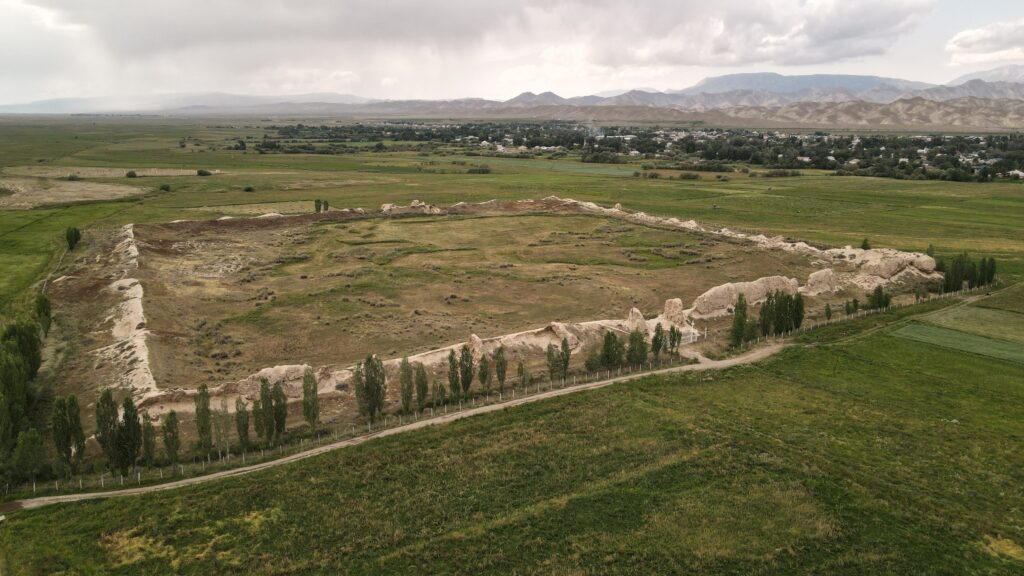
On the way back, we made a stop at Koshoy Korgon. At first glance, it didn’t look like much. Just a set of ancient earthen walls rising from the flat landscape. But in the small museum I learnt that Koshoy Korgon is believed to be the remains of an old fortified settlement, possibly dating back many centuries. Like Tash Rabat, it likely played a role along regional trade routes, offering protection and rest for passing caravans. Even in its current, weathered state, you can still imagine it as a once-busy stop in an otherwise vast and empty landscape.
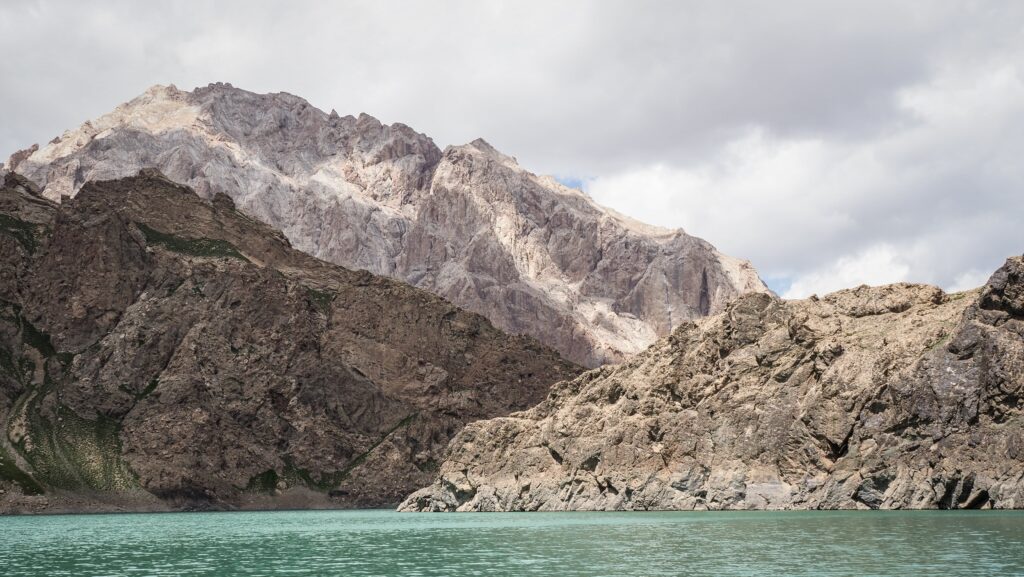
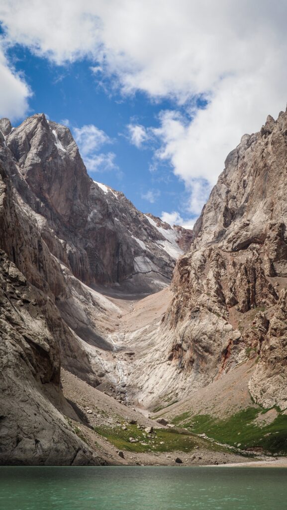
Kel-Suu is a remarkable high-mountain lake tucked into the rugged Naryn Region of eastern Kyrgyzstan, very close to the border with China. It sits at a significant altitude of over 3,400 meters above sea level, surrounded by tall rocky ridges and dramatic alpine scenery that changes with the seasons.
The name comes from the Kyrgyz language and relates to the idea of “flowing” or transient water. This reflects one of the lake’s most unusual traits: its water level doesn’t always behave predictably. At times, much of the lake’s water can drain away through underground channels and caves, leaving behind stark stone landscapes; at other times, it fills up again with meltwater from nearby glaciers and snowfields.
Although it looks like a classic glacial lake, Kel-Suu was actually created in the 1980s when a massive landslide blocked a valley, and water began to accumulate behind the natural dam. Today, its waters stretch roughly 9 km in length and vary in width from several hundred meters to almost two kilometres in places, though it remains relatively shallow compared with some other alpine lakes.
One of the defining aspects of Kel-Suu is how isolated it is. The approach leads through wide valleys, marshy ground, rivers, and high-altitude pastures, and because it lies within a border security zone, visitors must obtain a special permit ahead of time to enter the area. There’s no paved road all the way to the lake, so most travellers continue on foot or horseback from a yurt settlement in the nearby Kok-Kiya valley.
How to get to Kel Suu Lake?
Reaching Kel-Suu is an adventure in itself, as the lake lies in a remote border region of eastern Kyrgyzstan with no direct public transport.
Travel to Naryn city
Most journeys start in Bishkek, the capital. From there, travellers go to Naryn, either by shared taxi, minibus (marshrutka), private car or tour vehicle.
The trip usually takes 6–7 hours, crossing mountain passes and wide valleys.
Naryn to Kok-Kiya Valley
From Naryn, you continue east toward the Kok-Kiya area, which is the closest access point to the lake. This section requires a few hours of driving, depending on the weather and road conditions. In summer, usually a 4WD vehicle is not needed. The roads are unpaved but in very good condition, and even minibuses do this route all the time.
Border permit requirement
Kel-Suu is located in a restricted border zone near China, so foreign visitors must obtain a special permit in advance. This is usually organised through travel agencies in Bishkek or Naryn. If you sign up for an organised tour, they will take care of your permit as well. If you decide to travel independently, visit CBT Naryn(+996559567685, info@cbt-naryn.com), and they will help you out. Remember to apply for a permit a few days before your planned visit. As of 2025, the permit for foreigners cost 2.500 SOM and for locals 1.500 SOM.
Without this permit, access is denied at military checkpoints.
Final approach on foot or horseback
The last stretch to the lake typically involves a hike of 8–12 km (2–3 hours), or a horseback ride, which is common and easier at high altitude. The trail crosses alpine meadows, streams, and sometimes marshy ground.
Kel Suu Lake
Which organised tour to choose?
Most visitors arrange the visit to Kel See Lake through a tour operator. They offer an almost identical itinerary, which is usually a 3-day 2-night trip departing from Bishkek. Some popular companies are Kettik, Intourists, or Fun Travells. The prices are the same.
They can also pick you up in Naryn or drop you off there after the trip, in case you are not in Bishkek.
The best time to visit Kel Suu Lake
The lake is usually accessible from late June to early September. Outside this window, snow, flooding, or drained water levels can make the trip difficult or unrewarding.
During my several-day stay in Bishkek, I stayed in five different hotels:
Inter Hotel Bishkek: Probably the best price-to-quality ratio. Good locations, modern room.
Hotel Touristan: The room was huge and clean. The receptionist was super helpful, and I even received a fridge magnet as a gift. The only negative was that the AC didn’t work too well.
Malinka: More like a guesthouse rather than a hotel. The room was well equipped with a kettle, tea, sugar, and toiletries. Very friendly owner who let me leave a part of my luggage for several days as I was hiking in Ala Archa National Park.
Hotel T: Very simple, however, a comfortable room.
Terrasse Hotel & Bar: A luxurious establishment offering stunning panoramic views of the mountains and the city. I had to get a really good deal on booking.com as in the next days the rooms became 4 times more expensive.
Where to stay in Naryn?
If you decide to set off from Naryn, I recommend spending a few nights at Pamko. The place was spacious and clean. There was also a mini kitchen area, and the owner was very friendly. They kept my luggage safe while I was staying overnight in Tash Rabat.
Kel Suu Lake
Standard itinerary from Bishkek
The trips usually take 3 days with 2 nights spent in the yurts. Expect to pay between 9.000 – 10.000 SOM. The price included the transfer, accommodation in a yurt (2 nights), meals (2 breakfasts, 2 dinners, 1 lunch) and guide service. Permit is 2.500 SOM extra for foreigners and 1.500 SOM extra for the citizens of the Kyrgyz Republic.
Day 1
The gathering was at 6:00 AM, with departure planned for around 6:30 AM. Along the way, there were some scenic stops at Boom Gorge and the Orto-Tokoy Reservoir. After lunch in Naryn, we continued the journey toward the border control point. In the evening, we arrived at the yurt camp, followed by dinner and free time to relax and enjoy the surroundings. A nice surprise was that the yurts were heated, and it was really warm inside!
Day 2
After waking up, we enjoyed breakfast before beginning our ascent to the lake. There are several ways to reach Kel Suu: on foot, on horseback, or by 4×4 truck. The latter two options are available at an additional cost. A horseback ride to Kel Suu Lake costs 2,500 som for the horse and an additional 2,500 som for the guide. The guide fee can be shared among the group, making it a more budget-friendly option.
Hiking to the lake takes around 2-3 hours and follows an easy trail, mostly flat at the start, gradually climbing as it approaches the lake. Along the way, we were treated to beautiful views of snow-capped peaks and a fast-flowing river.
Kel Suu LakeKel Suu Lake
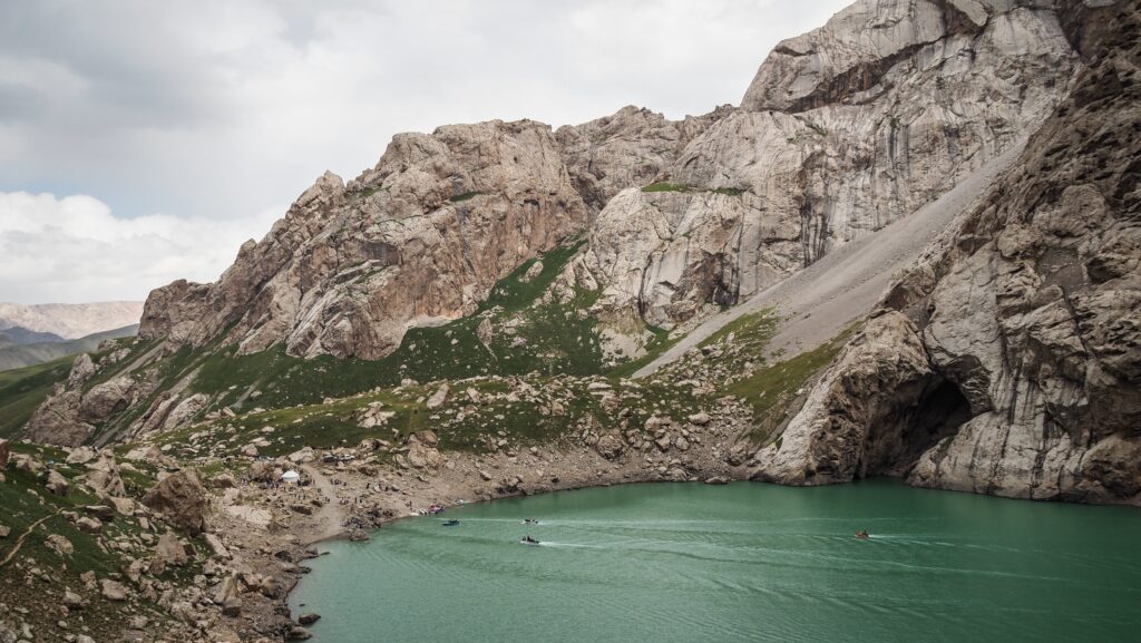
Upon reaching Kel Suu, there are simply no words, just wow. Towering rock formations rise dramatically above the water, while small boats glide quietly across the lake. I highly recommend taking a boat trip, as it was the highlight of the entire journey. The longest option lasts about 2–3 hours and takes you to the far end of the lake, including a stop at a cave. The ride can be chilly, especially as time goes on, so warm clothing is essential.
In the afternoon, we descended back to the yurt camp, where a well-deserved dinner and free time awaited, bringing a perfect end to an unforgettable day.
Day 3
After breakfast, we set off toward Bishkek, making a short stop near the water canyons along the way. It was a pleasant spot to stretch our legs and take in the scenery, with yaks grazing nearby, although the stop itself was fairly brief as we were encouraged to return to the bus.
The drive was smooth and efficient, and we made good time throughout the day. We stopped for lunch in Kemin, and by around 7:00 PM we arrived in Bishkek, much earlier than I had expected, which was a nice surprise.
Water canyonsLocal kids at the yurt campKok Kiya Valley
Q&A
Where is Kel Suu Lake located?
Kel Suu Lake is located in southeastern Kyrgyzstan, near the border with China. It sits in a remote alpine valley in the Naryn region at an altitude of around 3,500 meters.
How long should you spend at Kel Suu Lake?
Ideally, plan for 2 days / 1 night:
Day 1: Travel from Naryn to Kok-Kiya Valley
Day 2: Visit the lake and return
What is the best time to visit Kel Suu Lake?
The best time to visit is from June to September:
June–July: greener landscapes, possible snow
August–September: more stable weather and fewer crowds
Outside this period, access may be difficult due to snow and road conditions.
Is there a hike to Kel Suu Lake?
Yes, but it’s relatively short:
Around 6–8 km round trip depending on your starting point
Mostly flat, but at high altitude
You can also reach the lake on horseback if you prefer.
Where do you stay near Kel Suu Lake?
Most visitors stay in traditional yurt camps in the Kok-Kiya Valley:
Basic but comfortable
Home-cooked meals included
Incredible mountain views
Camping is also possible if you bring your own gear.
What should you pack for Kel Suu Lake?
Essential items include:
Warm layers (it gets cold even in summer)
Waterproof jacket
Hiking shoes
Sunscreen and sunglasses
Cash (no ATMs in the area)
Is Kel Suu Lake worth visiting?
Yes! It’s considered one of the most dramatic and remote landscapes in Kyrgyzstan. The combination of turquoise water, towering cliffs, and isolation makes it a truly unique destination.
Why does Kel Suu Lake sometimes disappear?
Kel Suu Lake is partially fed by underground rivers. Water levels can change significantly, and in rare cases the lake may temporarily shrink or “disappear,” revealing more of the canyon floor.
Just a short drive from the city of Naryn, Salkyn-Tor National Park is one of those places that locals know well but many travellers overlook. The park offers a refreshing mix of forests, rivers, and mountain scenery that feels worlds away from city life.
Established in 2001, Salkyn-Tor was created to protect the region’s natural landscapes and wildlife. The name itself gives a clue to what awaits visitors — “salkyn” means cool or fresh in Kyrgyz, an accurate description of the crisp mountain air and shaded valleys that make this area especially pleasant in summer.
The park covers a rugged terrain of gorges, pine and spruce forests, open meadows, and fast-flowing mountain streams. As you move deeper inside, the sounds of traffic fade, replaced by rushing water and birdsong. Wildlife such as maral deer, roe deer, lynx, and even brown bears inhabit the area, though sightings are rare and usually limited to quieter sections of the park.
One of the park’s biggest advantages is its proximity to Naryn. You don’t need a long expedition to experience mountain nature — within 20 kilometres, you’re surrounded by forests and peaks. Because of this, Salkyn-Tor plays an important role not only as a protected area, but also as a beloved recreational space for the region.
How to get to Salkyn-Tor?
Most visitors reach Salkyn-Tor National Park from Naryn, which has regular transport connections from Bishkek.
By car/taxi
That is basically the only way to get to Salkyn-Tor. If you don’t have your own wheels, you can find taxi drivers hanging out at Naryn Bus Station or just flag one down on the street. It’s about a 16 km trip from the centre of Naryn, and the drive takes about half an hour.
The best time to visit
The best time to visit is from June to September, when mountain roads are accessible, and the landscape is green and vibrant.
I spent a few nights at Pamko. The place was spacious and clean. There was also a mini kitchen area, and the owner was very friendly. They kept my luggage safe while I was staying overnight in Tash Rabat.
Hiking trails
Easy stroll along the stream
From the park’s entrance gate, simply follow the path as it traces the main stream winding through the valley. The walk is easy, and you can continue for as long as you like before turning back the same way. Along the route, you’ll pass a series of somewhat kitschy bridges and staged photo spots, which add a curious contrast to the otherwise peaceful mountain setting.
Loop trail via Ak Terek Pass
Distance: 12.7 km
Time: 4-6 hours
For hikers looking to explore more than just the lower valleys of Salkyn-Tor National Park, the loop trail via Ak-Terek Pass is one of the most rewarding routes in the area. Be warned, as the trail is challenging and can be difficult to find in some sections. However, it offers a full mountain experience with forested paths, wide alpine meadows, and sweeping views from a high pass.
The route begins by following a river valley that slowly rises through fragrant spruce forests and wide open pastureland. After a right-hand turn, the climb becomes more pronounced, leading steadily higher into the mountains. Because this trail sees few visitors, it isn’t always clearly defined, and losing it is surprisingly easy. Even though my position on Mapy.com appeared correct, I still had to push through sections of brush to reach Ak-Terek Pass, relying more on instinct than on a visible path.
Any uncertainty was quickly forgotten at the top. The panoramic views of surrounding ridgelines were striking, and I didn’t encounter a single other hiker for the entire day.
The descent on the far side of the pass was more straightforward, though navigation still required attention. Numerous parallel tracks created by grazing cattle crisscross the hillside, making it necessary to check the map frequently. Eventually, a clearer trail emerged, which I followed comfortably all the way down to the village and the main road.
Because of the trail’s remoteness and lack of signage, it’s wise to come prepared: download a reliable offline map, let someone know your plans in advance, or consider hiking with a companion.
Eki-Naryn is a small high-mountain settlement in the Naryn region of central Kyrgyzstan, located in a broad valley shaped by the upper course of the Naryn River. The name of the place is closely tied to its geography: in Kyrgyz, eki means “two,” and Naryn refers to the river, pointing to the fact that this area lies near the meeting point of two headwater branches that together form the Naryn River. These branches descend from the surrounding Tien Shan mountains and converge in the valley, giving the location both its name and its physical character.
The presence of the two river branches has long influenced life in Eki-Naryn. The rivers provide water for livestock and pastures, shape the wide valley floor, and create natural routes through the otherwise rugged mountain terrain. Historically, such river confluences were important landmarks for nomadic herders, serving as seasonal gathering points and reliable sources of water during migrations between summer and winter pastures.
How to get to Eki Naryn?
Most visitors reach Eki Naryn from Naryn, which has regular transport connections from Bishkek.
By car or taxi
That is basically the only way to get to Eki Naryn. If you don’t have your own wheels, you can find taxi drivers hanging out at Naryn Bus Station. It’s about a 42 km trip from the centre of Naryn, and the drive takes about an hour.
I negotiated the price of 2.500 som with the same driver that I met upon arrival from Kochkor. His name was Mars, and he was a fantastic guy, always listening to good music in his Land Cruiser. You may also contact him if you need a transfer to Tash Rabat or Kel Suu Lake. Phone number: +996 702 857 367.
There is no public transport, and I don’t recommend hitchhiking as the traffic is minimal and you may get stuck for several hours.
The landscape around Eki NarynThe landscape around Eki Naryn
The best time to visit
The best time to visit is from June to September, when mountain roads are accessible, and the landscape is green and vibrant.
Where to stay in Naryn?
I spent a few nights at Pamko. The place was spacious and clean. There was also a mini kitchen area, and the owner was very friendly. They kept my luggage safe while I was staying overnight in Tash Rabat.
Is it worth visiting Eki Naryn?
I don’t think a visit to Eki Naryn quite justifies the time and expense on its own. The scenery is beautiful, especially if you have a drone to capture it from above, but from ground level, it may feel less striking. That said, it can be a pleasant stop if you’re already travelling through the mountain roads on the way to Issyk-Kul Lake.
The landscape around Eki NarynThe landscape around Eki Naryn
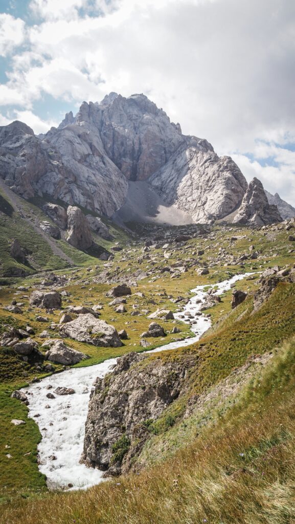
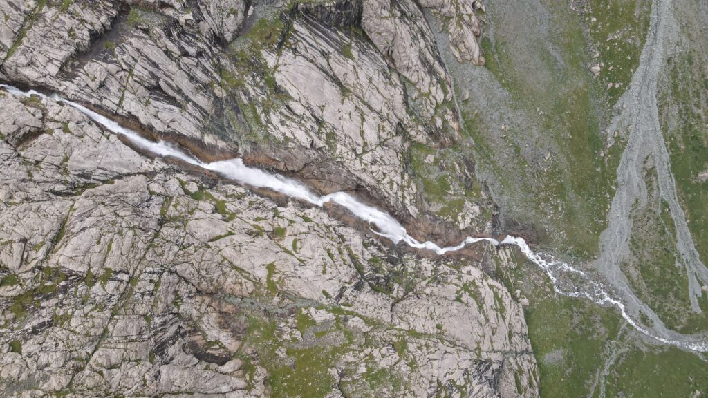
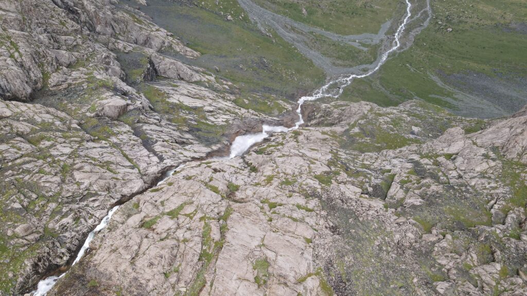
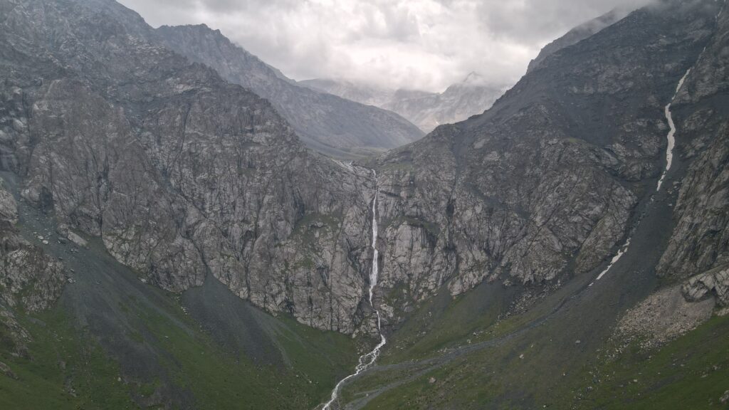
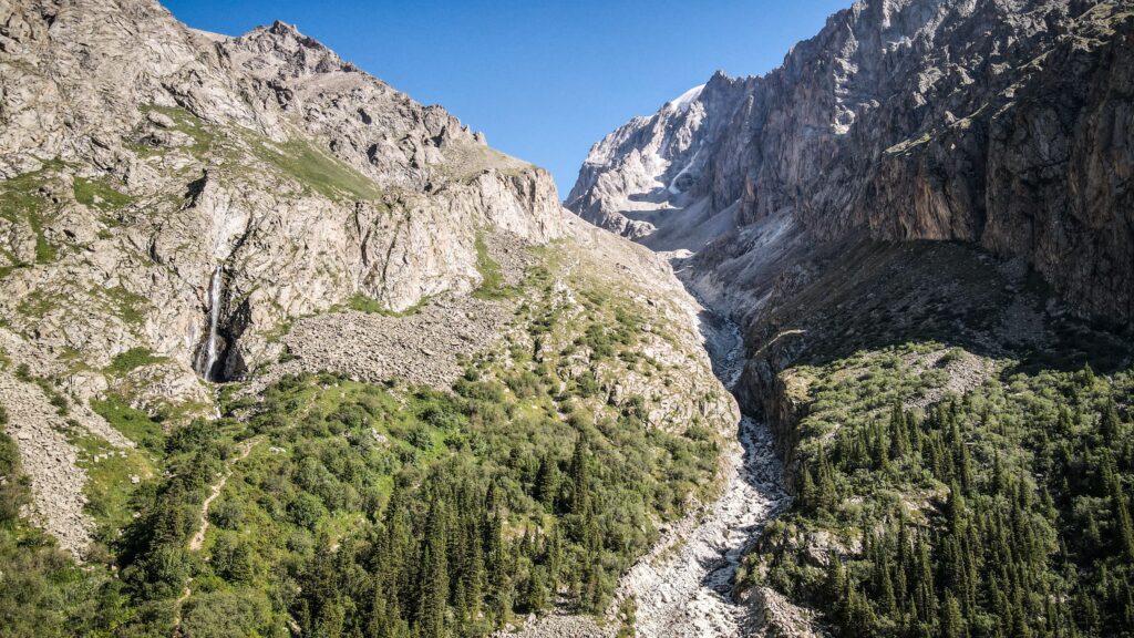
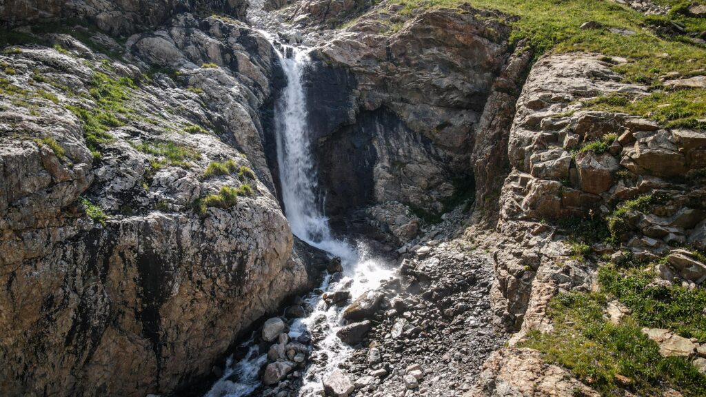
Shar Waterfall is a scenic natural attraction located in the Naryn Region of central Kyrgyzstan. It has a vertical drop of about 220 meters, but when its full series of cascades is included, the total height reaches roughly 400 meters, ranking it as the tallest waterfall in Central Asia. It is located at an elevation of around 3,200 meters above sea level, set within the dramatic gorge of the Bash-Kaindy River.
The waterfall flows down rocky terrain, which gives it a dynamic and visually appealing character. During late spring and summer, snowmelt from the surrounding mountains increases the water volume, making the waterfall especially impressive and refreshing. The surrounding area features open alpine meadows, wide valleys, and dramatic mountain backdrops.
How to get to Shar Waterfall?
Most visitors reach the waterfall from Naryn, which has regular transport connections from Bishkek.
By car
From Naryn, drive west toward Bash-Kaiyndy (about 60 km). Take the right turn off from the main road and head towards the river. You can either park your car here or try to cross on the other side and continue on the dirt road towards the yurt camps. The road is in good condition, and it should be doable in any car in dry conditions.
If you hike from the river crossing, it’s about 10 km one way (3-4 hours), so you certainly need to dedicate the whole day to it. The distance will be about 2-3 km shorter if starting from the yurt camp. You may also take the trip on a horse. If you wish, ask around in the village.
By public transport
Take a shared taxi or minibus from Naryn Bus Station toward Bash-Kaiyndy. If you are lucky, the driver may drop you off just at the river crossing, or you can even negotiate a drop off at the yurt camp.
On the way back, you will most likely need to hitchhike, at least to Ak Bashy, where you can find shared taxis going further to Naryn.
With a tour
Sometimes local companies such as Kettik or Intourist organise day trips there and to other locations around Kyrgyzstan. They can pick you up in Bishkek or en route in Naryn. Check their profiles on Instagram.
Upper area of the Shar Waterfall
The best time to visit Shar Waterfall
The best time to visit is from June to September, when mountain roads are accessible, and the landscape is green and vibrant.
Where to stay in Naryn?
I spent a few nights at Pamko. The place was spacious and clean. There was also a mini kitchen area, and the owner was very friendly. They kept my luggage safe while I was staying overnight in Tash Rabat.
Shar Waterfall
My experience at Shar Waterfall
I took a shared taxi to the village of Bash-Kaiyndy, the trailhead for Shar Waterfall. Taxi drivers in Kyrgyzstan have a unique charm: they’re somehow both delightful and exasperating at the same time. They drive with wild confidence and are eager to strike up conversations even when it’s painfully obvious that I don’t understand a word of Russian.
The trail itself was long and wonderfully quiet. All the way to the waterfall, I didn’t encounter a single other person. As I got closer and the falls came into view, the weather began to turn, and light rain eventually set in. Nothing too intense, though. The waterfall was stunning, shaped like a rocky amphitheatre with the water cascading down right at its centre. Being completely alone there made the experience feel even more special.
Shar WaterfallShar Waterfall
Fortunately, the rain came and went, and before long, the sky cleared, and the sun returned. I was able to fly my drone and capture some truly impressive footage.
On the hike back, I finally crossed paths with other tourists, followed by a group travelling on horseback. By the time I reached the village again, I was exhausted, and it was already getting late, so I started looking for a ride back to Naryn. I first hitched a ride to Ak Bashy village, and from there, a taxi driver dropped me at the exit road, where another shared taxi was waiting for passengers.
In the end, it was just the driver and me. He asked for 200 som, so an unbelievably low price. I couldn’t tell whether he was a professional driver running this route regularly or simply heading that way anyway, but if it was the former, I honestly don’t know how 200 som could cover the time and fuel. Either way, he was incredibly friendly and spoke some basic English, so we chatted the entire way back.
Ala Archa National Park is one of Kyrgyzstan’s most popular natural reserves, located about 40 kilometres south of Bishkek in the Tian Shan Mountains. The park is renowned for its dramatic alpine scenery, featuring snow-capped peaks, glaciers, and high ridges. It is a favourite destination of locals for hiking, climbing, and picnicking, offering trails that range from short walks along the river to challenging treks up to glaciers and mountain huts.
The park is home to diverse wildlife, including ibex, marmots, and a variety of bird species, as well as rich alpine flora. Its proximity to the capital makes it an easily accessible escape into nature.
How to get to Ala Archa?
Getting to Ala Archa National Park is quite straightforward since it lies only about 40 kilometres south of Bishkek. First, you will need to get to the official entrance, where you can buy a ticket and change to official minibuses, which can take you further into the park. Most visitors start from the capital, where you have a few options:
By Car or Taxi
The easiest way is to take a taxi or arrange a private transfer. The drive takes around 40–50 minutes, following the main road that leads straight to the park’s entrance. Expect to pay about 800 – 1000 SOM for a Yandex taxi from the Bishkek city centre.
By Bus
Bus #1 goes from Bishkek city all the way to the park entrance. You can see its route HERE.
By Minibus (marshrutka)
Budget travellers can catch a marshrutka from Bishkek heading in the direction of Kashka Suu. You’ll need to get off at the park turnoff and continue either on foot or arrange local transport for the last stretch to the gate. Not very convenient.
Guided Tours
Many local agencies in Bishkek offer half-day or full-day trips, which include transport and a guide, making it a convenient option for those who prefer not to plan logistics themselves. Your time in the park will be limited, though, and I honestly do not know what the point of half-day trips is. I guess just taking a photo from the viewpoint and going back to Bishkek. This park definitely deserves more of your time and energy!
Camp Elektro
The best time to visit Ala Archa
Spring (April–May): The park comes alive with blooming wildflowers, and the weather is mild, making it a pleasant season for day hikes. Some higher trails may still have snow.
Summer (June–August): This is the most popular season. Trails are fully accessible, and the weather is warm but cooler than in Bishkek, offering great conditions for longer treks and climbing.
Autumn (September–October): Crisp air, fewer crowds, and colourful landscapes make this one of the most beautiful times for photography and hiking.
Winter (November–March): Snow covers the park, creating opportunities for skiing and ice climbing, but many trails become inaccessible without special gear.
How much does the entrance cost?
Visitors to Ala Archa National Park are required to pay an entrance fee of 200 KGS, which is collected at the main gate. Payment by card is possible. From the gate, an electric shuttle or minibus operates to take guests further inside the park, covering the roughly 12-kilometre distance. The ride is included in the entrance ticket.
Ala Archa National Park
Where to stay in Ala Archa National Park?
Along the main asphalt road, you can find Alp Lager Hotel as well as guesthouses and cabins just outside or near the park gate.
Camping is possible anywhere in the park and is perfectly legal. On the Mapy.com app, you can see several locations indicated as campsites. There are no facilities, but usually it’s just a flat terrain suitable for pitching your tent.
Alternatively, you can hike up to Ratsek Hut, though it is a good idea to arrange a spot in advance by contacting Ak-Sai Travel at 0312-909-356 or adventure@ak-sai.com. They also provide meals in the hut.
Ala Archa National Park
Where to stay in Bishkek?
During my several-day stay in Bishkek, I stayed in four different hotels:
Inter Hotel Bishkek: Probably the best price-to-quality ratio. Good locations, modern room.
Hotel Touristan: The room was huge and clean. The receptionist was super helpful, and I even received a fridge magnet as a gift. The only negative was that the AC didn’t work too well.
Malinka: More like a guesthouse rather than a hotel. The room was well equipped with a kettle, tea, sugar, and toiletries. Very friendly owner who let me leave a part of my luggage for several days as I was hiking in Ala Archa National Park.
Hotel T: Very simple, however, a comfortable room.
Terrasse Hotel & Bar: A luxurious establishment offering stunning panoramic views of the mountains and the city. I had to get a really good deal on booking.com, as in the next days the rooms became 4 times more expensive
Ala Archa National Park
FAQ
Do you need a guide to Ala Archa?
No, a guide is not required to Ala Archa; you can go there on your own. Getting there and navigating the area is relatively easy. However, a guide can be useful if you don’t have any mountain experience or if you prefer not to worry about logistics, weather, or orientation. For those who enjoy exploring at their own pace and prepare in advance, a self-guided visit to Ala Archa is perfectly sufficient.
Is Ala Archa suitable for a day trip?
Yes, Ala Archa is very suitable for a day trip. The park is relatively close to Bishkek (about 40 km), so you can easily get there in the morning and then spend the day walking, picnicking, and shorter treks in the valley. Many people choose day trips.
Are the trails in Ala Archa well-marked?
The trails in Ala Archa are largely well-marked in the lower part of the park, closer to the entrance. On the main trails, such as those towards Ak-Sai Falls or along the river valley, you’ll find marked paths and maps at the entrance, and the trail itself is clearly marked enough for most people to find it easily. As you go deeper into the park, the markings become less frequent, so it’s a good idea to have a map or a route app handy.
Hiking trails in Ala Archa National Park
Ak Say Waterfall
Distance: 8 km / Time: 5 hours (there and back) / Elevation gain: 670 m
The hike begins from Alp Lager, the base area where most trails in Ala Archa start. At first, the trail follows asphalt and then dirt road, with sweeping views of the valley already visible behind you. The route is well-trodden and easy to follow, but it gains elevation quickly, so you’ll feel the climb right away.
After about an hour, the terrain becomes steeper and more exposed. There are few trees along this section, meaning the sun beats down strongly. The higher you go, the more dramatic the scenery becomes, with sharp ridgelines on either side.
Eventually, the sound of the Ak-Say Waterfall grows louder until you round a corner and see it plunging from the cliffs above. The spot is popular, especially on weekends, so expect to meet fellow hikers pausing for photos and snacks. Despite the crowds, it’s a stunning natural highlight and a rewarding destination for a half-day outing.
From here, many trekkers choose to turn back, but the trail continues upward toward Ratsek Hut and the Uchitel Glacier for those with more time and energy. Read more about it further down.
Ak Say Waterfall
Komsomolets Peak
Distance: 14,2 km / Time: 10-11 hours (there and back) / Elevation gain: 2,009 m
The trail first follows the same route toward Ak Say Waterfall before branching off onto steeper ground. The climb is long and demanding, with rocky ridges and sections of scree requiring steady footing. As you gain elevation, the panorama widens to reveal glaciers and neighbouring summits of the Kyrgyz Ala-Too range. It’s a strenuous outing best suited for strong hikers, but the sense of accomplishment at the top is unforgettable.
Intourists occasionally organises group hikes there, in case you don’t want to climb it solo.
Hut at the Golubin Glacier (Khizhina U Lednika Golubina)
Distance: 21,5 km / Time: around 8-9 hours (there and back) / Elevation gain: 1,069 m
This hike follows a scenic route along the left side of the river before climbing gradually toward the moraine of the Golubin Glacier. The destination is an abandoned and collapsed hut tucked beneath towering peaks. The trail is moderately challenging, with sections across rocky terrain, but the scenery is breathtaking throughout. Glacial streams, alpine meadows, and rugged cliffs make this one of the most picturesque valleys in Ala Archa.
Adygene Lake
Distance: 18 km / Time: around 9-10 hours (there and back)
The hike to Adygene Lake starts just before the final stop of the minibus, so it’s worth asking the driver to drop you at the right spot. When I arrived, there was some construction nearby, so I had to detour a little to find the trail. I was the only one stepping off the bus, and for most of the day, I met only a handful of other hikers, which made the journey feel wonderfully remote.
The trail followed the river for a while until it was time to cross. River crossings usually make me nervous, but this one turned out to be fairly straightforward. Higher up the path, I finally spotted some fellow hikers, a lively group of teenagers who showed me the way down a cliff and across another stream.
A bit later, I reached Camp Elektro, where I stopped for a snack and a quick chat with another hiker heading up to Elektro Summit. From there, the route to the lake grew tougher. The final section led across a vast field of boulders, requiring careful steps to avoid twisting an ankle. With no trail markings, I relied on my map app to keep me on course.
Eventually, the turquoise waters of Adygene Lake came into view, along with a small hut nearby. Getting there wasn’t simple, and the last challenge was balancing across a rough wooden plank laid over a fast-moving stream. Once I made it, I sat down for lunch, flew my drone to capture the stunning scenery, and soaked in the quiet beauty of the place.
The hike back felt livelier. I crossed paths with more hikers, especially in the valley below Camp Elektro. On the descent, I chose a track on the right-hand side, which led me down to the main road. By the time I reached the central area of the park, the solitude of the lake was replaced by crowds, snack stands, and the comfort of a cold cola. From there, I wandered off to look for a place to camp for the night.
Ala Archa National ParkAla Archa National ParkAla Archa National Park
Agitator Peak
Distance: 16,2 km / Time: around 10-12 hours (there and back) / Elevation gain: 2,150 m
For those looking for a rewarding climb, the hike to Pik Agitatorov (4,244 m) offers the perfect balance. The route begins from the same spot as the trail to Adygene Lake, leading up through rocky slopes and grassy ridges. The ascent is steep and requires good stamina. From the summit, the panorama over the surrounding peaks is magnificent.
Intourists occasionally organises group hikes there, in case you don’t want to climb it solo.
The Abandoned Ski Resort “Upper Ala-Archa”
Distance: 31 km / Time: 10-12 hours (there and back) / Elevation gain: 1,244 m
I set out along the trail on the right side of the river, following advice I’d read online. It turned out to be the right choice as ater on, I noticed how powerful the water on the left side was, and crossing there would have been nearly impossible.
Even so, the right path wasn’t always straightforward. Sections were overgrown and lacked clear markings, so I relied on intuition and my offline map to stay on track. As the climb began, the trail gradually opened up to a flatter stretch where a small lake appeared. I paused for a rest and saw a group coming from the opposite direction, so they must have camped somewhere nearby.
Further along, I passed the remains of an abandoned weather station. The landscape here was breathtaking: lush meadows, free-roaming horses, streams winding through the grass, and wide green valleys. Occasionally, I had to hop across boulders to keep my boots dry.
The Abandoned Ski Resort “Upper Ala-Archa”Mountain panoramaWaterfall
As I gained more altitude, the greenery gave way to a harsher terrain of bare rocks and scattered stones. Eventually, I reached a stream with just a few meters left to climb before arriving at the ruins of the old ski station. I sent my drone up to capture the wide panorama and then climbed a bit higher on foot for a better view of the glacier beyond. If the stream feels too tricky to cross, stick to the right bank and look for an easier crossing point further down.
The way back was less demanding since it was downhill, but fatigue and the afternoon heat started to set in. I stopped to search for an abandoned crawler tractor I’d heard about and launched the drone again near a striking waterfall.
Retracing my steps past the weather station, I met a group of hikers heading up. They were clearly planning to camp in the area, which actually seemed like a perfect spot. Before moving on, I splashed my face in the icy stream to cool down, then carried on until I reached my camping place near the bridge. Camping there saved me a bit of distance, but for anyone starting from Alp Lager, this hike makes for a long and demanding full-day adventure.
Ratsek Hut and Uchitel Glacier
Distance: 14,5 km / Time: 8-10 hours (there and back) / Elevation gain: 1,460 m
Because of the ongoing cable car construction, the route to Ratsek Hut begins along a wide dirt road that climbs steadily upward toward a rock formation known as the “Broken Heart.” This landmark is a cliff face split down the middle, resembling a heart cracked in two, and it’s a well-known viewpoint in Ala Archa National Park. The climb here is fairly steep and fully exposed, so carrying enough water and applying sunblock is essential.
I paused for a longer break at the Ak-Say Waterfall, a spectacular cascade tumbling into the gorge below. It was beautiful but not exactly tranquil since it was the weekend, and plenty of other hikers were making their way up the same trail.
Aksai GlacierUchitel Glacier and the lakeAla Archa National Park
From there, the path steepens for the final push to Ratsek Hut. Reaching the camp felt rewarding, and I quickly set up my tent in an available spot before heading inside the hut for food and refreshments. The solyanka soup was delicious and hearty, just what I needed after the climb, and I couldn’t resist treating myself to a cold cola. I also arranged dinner for later. The campsite was buzzing with activity: tents scattered across the meadows, climbers preparing their gear, and others settling into bunk beds inside the hut. This spot is a hub for both trekkers and rock climbers, giving it a lively, communal atmosphere.
Later in the afternoon, I continued further up the trail toward the Uchitel Glacier and its small glacial lake. The last stretch was tricky, requiring careful navigation across a boulder field. When I finally arrived, I was greeted by a dramatic scene: the lake, backed by an immense wall of ice that occasionally shed stones and chunks into the water with a thunderous crash.
Back at the hut, dinner was served – a simple stew with noodles. Not that impressive, but filling enough after a long day on the trail.
Hikes from Ratsek Hut
Uchitel Peak
Distance: 5.6 km / Time: 5-6 hours (there and back) / Elevation gain: 1,155 m
I woke up before dawn, setting out on the trail to Uchitel Summit just after 6 AM. The area was still quiet, and for the first part of the climb, I didn’t see a single other hiker. The path was long and relentlessly steep, and in places it almost disappeared. Luckily, I was able to see the trail and my position on Mapy.com. I slipped once, sending loose stones tumbling down the incline, and for a moment, my heart was in my throat.
Pushing upward, I eventually caught sight of tiny figures silhouetted on the summit far above. Just knowing others had already made it there gave me a boost of motivation. The final stretch was a demanding mix of snow on the left and jagged rocks on the right, but step by step, I closed the distance.
The panorama stretched endlessly across the Ala Archa range, peaks and glaciers glowing in the morning light. A couple who had camped overnight were packing up their tent, and two other hikers lingered a while before starting their descent. Soon, I was alone on the summit. Just me, the mountains, and the silence. It was an unforgettable moment.
The way down, though steep, felt easier; somehow, the route was clearer when looking at it from above. By then, more hikers had begun their ascent, filling the trail that had been empty just hours earlier.
Uchitel PeakUchitel Peak
Korona Hut
Distance: 6 km / Time: 5-6 hours (there and back)
The route to Korona Hut climbs steadily toward the foot of the massive Korona Peak, named for its crown-shaped summit ridge. The trail crosses a mix of rocky moraines and glacial terrain, often requiring careful footing on loose stones. As you get closer, the jagged spires of Korona tower above, and the hut itself comes into view, perched on a rocky outcrop with front-row views of the glacier. It’s a rugged but spectacular spot, often used by climbers preparing for ascents of nearby peaks.
Nauka Hut
Distance: 5.9 km / Time: 4-5 hours (there and back)
The hike to Nauka Hut branches in another direction, heading toward the Ak-Sai Glacier. This path also demands attention, as it crosses boulder fields and uneven ground, but it is rewarded with stark high-mountain views. The hut, a modest structure built for climbers and researchers, sits in a breathtaking setting directly beneath the icefall.